
Srikakulam is a city and the headquarters of Srikakulam district in the Indian state of Andhra Pradesh. As of 2011 census,. it has a population of 165,735. There are many other places of Buddhist Tourism such as Salihundam, Calinga Patnam, Dabbaka Vaani Peta, Nagari Peta, Jagati Metta, Singupuram etc. in Srikakulam District. The Buddhist heritage site of Salihundam has some unique features. It has a beautiful star atop a stupa, rock cut massive stupaas inside chaitya grihas, brick stupas with wheel pattern plan, votive stupas, inscriptions on the steps leading to the stupas and museum housing over two dozen sculpted statue and figurines of Buddha, Jain Teerthankars and other deities

Vizianagaram district is one of the eleven districts in the Coastal Andhra region of the Indian state of Andhra Pradesh with its headquarters located at Vizianagaram. The district is bounded on the east by the district of Srikakulam, north by Parvathipuram Manyam southeast by Visakhapatnam, south by Anakapalli, southeast by the Bay of Bengal, and northwest by the state of Odisha. It was formed on 1 June 1979, with some parts carved from the neighbouring districts of Srikakulam and Visakhapatnam. The district is named after the princely state of Vizianagaram. It is the least populous district in Andhra Pradesh.

Srikakulam district is one of the twenty-six districts in the Coastal Andhra region of the Indian state of Andhra Pradesh, with its headquarters located at Srikakulam. It is one of the nine coastal districts, located in the extreme northeastern direction of the state. It was formerly known as Chicacole.

Arasavalli is an outgrowth of Srikakulam municipality in Srikakulam district of the Indian state of Andhra Pradesh. It is located in Srikakulam mandal of Srikakulam revenue division. It is situated at a distance of about 1.6 km. from Srikakulam, the district headquarters and 17 km. from Srikakulam road, the railway station on Visakhapatnam-Howrah Line.

Amadalavalasa is a town in Srikakulam district of the Indian state of Andhra Pradesh. It is a municipality and also the mandal headquarters of Amadalavalasa mandal. The town is spread over an area of 19.65 km2 (7.59 sq mi), which is under the jurisdiction of Visakhapatnam Metropolitan Region Development Authority. Srikakulam Road railway station is situated at Amadalavalasa.

Sompeta is a census town in Srikakulam district of the Indian state of Andhra Pradesh. It is the mandal headquarters of Sompeta mandal in Tekkali revenue division.
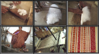
Ponduru is a census town in Srikakulam district of the Indian state of Andhra Pradesh. The town is the mandal headquarters of Ponduru mandal in Srikakulam revenue division. It falls under the Amadalavalasa Assembly Constituency and Srikakulam Loksabha Constituency.

Hiramandalam is a census town in Srikakulam district of the Indian state of Andhra Pradesh. It is also the mandal headquarters of Hiramandalam mandal in Palakonda revenue division. BRR Project Located at Hiramandalam town. It is located 49 km towards North from District headquarters Srikakulam.
Jalamuru is a village in Srikakulam district of the Indian state of Andhra Pradesh. Jalumuru mandal is bordered by Narasannapeta, Sarubujjili, Saravakota and Kotabommali mandals of Srikakulam district.
Kaviti is a village in Srikakulam district of the Indian state of Andhra Pradesh. Kaviti mandal is bordered by Ichchapuram mandal to the north, Kanchili and Sompeta mandals to the south, Odisha state to the west and the Bay of Bengal to the east.
Kotturu is a village in Srikakulam district of the Indian state of Andhra Pradesh. It is located in Kothuru mandal of Palakonda revenue division.

Narasannapeta is a census town in Srikakulam district of the Indian state of Andhra Pradesh. It is the mandal headquarters of Narasannapeta mandal in Srikakulam revenue division. 43 villages are there under the administrative division of Narasannapeta.

Pathapatnam is a town in Srikakulam district of the Indian state of Andhra Pradesh. It is located in Pathapatnam mandal of Palakonda revenue division. Pathapatnam is located on the border of Srikakulam district of Andhra Pradesh and Gajapati district of Odisha. Parlakhemundi, the headquarters of Gajapati District, can be considered as twin town of Pathapatnam because of its close proximity. It is located around 65 km from srikakulam.
Polaki is a village in Srikakulam district of Andhra Pradesh in India.
Santhabommali is a village in Srikakulam district of the Indian state of Andhra Pradesh.

Tekkali is a census town in Srikakulam district of the Indian state of Andhra Pradesh. It is the mandal headquarters of Tekkali mandal in Tekkali revenue division and is located at a distance of 51 KM from the district headquarters. The prominent actor Nandhamuri Taraka RamaRao represented this assembly constituency in AndhraPradesh General Legislative assembly Elections 1994.
Vajrapu-kotturu is a village in Srikakulam district of the Indian state of Andhra Pradesh. Vajrapukotturu mandal is bordered by Mandasa, Palasa, Nandigam and Santha Bommali mandals of Srikakulam district and has a long coastline off Bay of Bengal. Bendi Gedda river joins the sea after forming a lagoon in this mandal area.
Etcherla Assembly constituency is a constituency in Srikakulam district of Andhra Pradesh. It is one of the seven assembly segments of Vizianagaram, along with Rajam (SC), Bobbili, Cheepurupalli, Gajapathinagaram, Nellimarla and Vizianagaram. As of 25 March 2019, there are a total of 231,279 electors in the constituency. Gorle Kiran Kumar is the present MLA of the constituency, who won the 2019 Andhra Pradesh Legislative Assembly election from YSR Congress Party.
Srikakulam revenue division is a revenue division in the Srikakulam district of the Indian state of Andhra Pradesh. It is one of the three revenue divisions in the district with thirteen mandals under its administration. The divisional headquarters are located at Srikakulam.

Dr. B. R. Ambedkar University, Srikakulam is a state university located in Etcherla, Srikakulam district, Andhra Pradesh, India. It was established in 2008 by the Government of Andhra Pradesh. The university is named after B. R. Ambedkar, the father of the Constitution of India.

