Related Research Articles

Karimnagar is also known as Elagandula is a city and District Headquarters in the Indian state of Telangana. Karimnagar is a major urban agglomeration and fifth largest City in the state. It is governed by Municipal corporation and is the headquarters of the Karimnagar district It is situated on the banks of Manair River, which is a tributary of the Godavari River.It is the third largest and fastest growing urban settlement in the state, according to 2011 census. It has registered a population growth rate of 45.46% and 38.87% respectively over the past two decades between 1991 and 2011, which is highest growth rate among major cities of Telangana. It serves as a major educational and health hub for the northern districts of Telangana. It is a major business center and widely known for its agricultural and granite industries, earning the nickname "City of Granites."

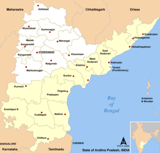
Telangana is a state in India situated on the south-central stretch of the Indian peninsula on the high Deccan Plateau. It is the eleventh-largest state and the twelfth-most populated state in India with a geographical area of 112,077 km2 (43,273 sq mi) and 35,193,978 residents as per 2011 census. On 2 June 2014, the area was separated from the northwestern part of Andhra Pradesh as the newly formed state of Telangana, with Hyderabad as its capital. Its other major cities include Warangal, Nizamabad, Khammam, Karimnagar and Ramagundam. Telangana is bordered by the states of Maharashtra to the north, Chhattisgarh to the northeast, Karnataka to the west, and Andhra Pradesh to the east and south. The terrain of Telangana consists mostly of the Deccan Plateau with dense forests covering an area of 27,292 km2 (10,538 sq mi). As of 2019, the state of Telangana is divided into 33 districts.

Nizamabad is also known as Induru is a city in the Indian state of Telangana. Nizamabad is a major urban agglomeration and third largest city in the state. It is governed by municipal corporation and is the headquarters of the Nizamabad district. Although previously part of Hyderabad State and then Andhra Pradesh state, Nizamabad became a part of the newly formed state of Telangana by the Andhra Pradesh Reorganisation Act, 2014.It is located about 186 kilometres (116 mi) north of the state capital, Hyderabad.

Adilabad is a city which serves as the headquarters of Adilabad district, in the Indian state of Telangana. Telugu is the native language of Adilabad. Adilabad is famous for its rich cultivation of cotton. Hence, Adilabad is also referred as "White Gold City". It is located about 304 kilometres (189 mi) north of the state capital, Hyderabad, 150 kilometres (93 mi) from Nizamabad and 196 kilometres (122 mi) from Nagpur. Adilabad is called as the "Gateway to South India".

Karimnagar district is one of the 33 districts of the Indian state of Telangana. Karimnagar city is its administrative headquarters. The district shares boundaries with Peddapalli, Jagityal, Sircilla, Siddipet, Jangaon, Hanamkonda district and Jayashankar Bhupalapally districts.

Nizamabad district is a district located in the north-western region in the Indian state of Telangana. The city of Nizamabad is the district headquarters.It was known as " Indur " which was supposed to have originated from the name of the King was Indradatta who seems to have flourished it during the 5th century A.D.The district share boundaries with Jagtial, Sircilla, Nirmal, Kamareddy districts and with Nanded district of the state boundary of Maharashtra.
Telugu people, also Telugus or Telugu vaaru, are the largest of the four major Dravidian ethnolinguistic groups in terms of population. Telugus are native to the Indian states of Andhra Pradesh, Telangana and the Yanam district of Puducherry. A significant number of Telugus also reside in the surrounding Indian states of Karnataka, Tamil Nadu, Maharashtra, Gujarat, West Bengal, Chhattisgarh, Kerala, and Odisha, as well in the union territory of Andaman and Nicobar Islands. Telugus claim descent from the Andhras, from whom the Telugus inherit their ethnonym. Telugu is the fourth most spoken language in India and the 15th most spoken language in the world.
Nethakani, also known as Netkani,As Nethkani in Maharashtra,In the state of Telangana it is known as nethakaani. are a Maratha and Telugu caste of cotton weavers and laborers.
Karnataka is a state in the southern part of India. It was created on 1 November 1956, with the passing of the States Reorganisation Act. Karnataka is bordered by the Arabian Sea to the west, Goa to the north-west, Maharashtra to the north, Telangana and Andhra Pradesh to the east, Tamil Nadu to the south-east, and Kerala to the south-west. The state covers an area of 74,122 sq mi (191,976 km2), or 5.83% of the total geographical area of India. It comprises 30 districts. Kannada is the official language of Karnataka and as per the 2011 census is the mother tongue of 66.5% of the population. Various ethnic groups with origins in other parts of India have unique customs and use languages at home other than Kannada, adding to the cultural diversity of the state. Significant linguistic minorities in the state in 2011 included speakers of Urdu (10.8%), Telugu (5.8%), Tamil (3.5%), Marathi (3.4%), Hindi (3.2%), Tulu (2.6%), Konkani (1.3%) and Malayalam (1.3%).
Tamil Nadu is one of the 28 states of India. Its capital and largest city is Chennai. Tamil Nadu lies in the southernmost part of the Indian Peninsula and is bordered by the States of Puducherry, Kerala, Karnataka and Andhra Pradesh. It is the tenth-largest state in India and the seventh most populous state.
This article gives a list of the territories of the dioceses of the Catholic Church in India.

Adilabad district is a district located in the northern region of Telangana, India. It is known as the gateway district to South and Central India. The town of Adilabad is its headquarters. The district shares boundaries with Asifabad, Nirmal districts and with the state boundary of Maharashtra.
Telangana has multiple institutes of higher education universities along with numerous primary and secondary schools.
Other gondi
Mancherial district is a district located in the northern region of the Indian state of Telangana. The district comprises 18 mandals and two revenue divisions – Mancherial and Bellampalli. The district headquarters is located at Mancherial town. It is surrounded by Komaram Bheem, Nirmal, Jagtial, Peddapalli and Bhupalpally districts of Telangana and with Maharashtra state.

Nirmal district is a district located in the northern region of the Indian state of Telangana. The district headquarters is located in the town of Nirmal. It borders the Telangana districts of Adilabad, Nizamabad, Mancherial, Asifabad, Jagtial districts as well as Nanded district of the state Maharashtra.

Kamareddy district is a district located in the northern region of the Indian state of Telangana. The district shares boundaries with Medak, Nizamabad, Sangareddy, Siddipet and Rajanna Sircilla districts and with the state boundary of Maharashtra and Karnataka.

Jagtial district is a district located in the northern region of the Indian state of Telangana. Its headquarters is Jagtial. The district shares boundaries with Nirmal, Mancherial, Karimnagar, Peddapalli, Sircilla and Nizamabad districts.
Telugu states are the Indian states of Andhra Pradesh and Telangana in southeastern India. An ethno-region of Telugu people, they as a collective are bordered by Maharashtra to the north, Karnataka to the west, Odisha, Chhattisgarh to the northeast, Tamil Nadu to the south and the Bay of Bengal, Yanam district enclave of Puducherry to the east. The referential term of Telugu states has been in use ever since the bifurcation of its preceding political entity United Andhra Pradesh in 2014. Combining Telangana's population of 35,193,978 and Andhra Pradesh's of 49,506,799, the Telugu states have a population of 84,700,777 as of 2011.
References
- ↑ A. R. Fatihi. "Urdu in Karnataka". Language in India, Volume 2: 2002-12-09. M. S. Thirumalai, Managing Editor, Language in India. Retrieved 29 June 2007.
- ↑ "The Andhra Pradesh Official Language Act" (PDF). Official website of Department of Parliamentary Affairs and Legislation. Government of Andhra Pradesh. Retrieved 29 June 2007.
- ↑ "PART-A: DISTRIBUTION OF THE 22 SCHEDULED LANGUAGES-INDIA/STATES/UNION TERRITORIES - 2011 CENSUS" (PDF). Census India.
- ↑ Government of Tamil Nadu — Tamil Nadu Secretariat — Brief History
- ↑ Historical Importance of Kanchipuram Archived 18 May 2006 at the Wayback Machine