External links
| | This article about the European Union is a stub. You can help Wikipedia by expanding it. |
The European Soil Bureau Network (ESBN), located at the Joint Research Centre (JRC) of the European Commission, Ispra(I), was created in 1996 as a network of national soil science institutions. The ESBN at the JRC is operated by staff members of the Land Management Unit (LMU). Its main tasks are to collect, harmonise, organise and distribute soil information for Europe. [1] This section describes the history, background and current work programme of the network.
The European Soil Bureau is a Network of "Centres of Excellence". In general terms, therefore, the role the ESBN Project at the JRC is twofold - to perform a co-ordination activity by hosting the Secretariat of the ESBN and to provide a central source for information relevant to the work of the European Commission.
The ESBN is experiencing a surge in the demand for soil information in Europe, for addressing a number of environmental problems and questions. These include: leaching of agrochemicals, deposition of heavy metals, disposal of waste (agricultural, domestic and industrial), degradation of soil structure (through loss of soil organic matter, salinisation and subsoil compaction), risk of erosion (by water and wind), immobilisation of radionuclides, supply of water at catchment level, assessing the suitability (and sustainability) for traditional and alternative crops, and estimation of soil stability.
| | This article about the European Union is a stub. You can help Wikipedia by expanding it. |

Putnam County is a county located in the central portion of the U.S. state of Georgia. As of the 2020 census, the population was 22,047. The county seat is Eatonton.

Treutlen County is a county located in the east central and Magnolia midlands portion of the U.S. state of Georgia. As of the 2020 census, the population was 6,406. The county seat is Soperton. Treutlen County is host to the Million Pines Arts and Crafts Festival which takes place during the first weekend in November.

Jasper County is a county located in the central portion of the U.S. state of Georgia. As of the 2020 census, the population was 14,588, up from 13,900 in 2010. The county seat is Monticello. Jasper County is part of the Atlanta-Sandy Springs-Roswell MSA.
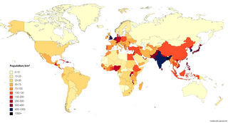
Population density is a measurement of population per unit land area. It is mostly applied to humans, but sometimes to other living organisms too. It is a key geographical term.
The Global Earth Observation System of Systems (GEOSS) was built by the Group on Earth Observations (GEO) on the basis of a 10-Year Implementation Plan running from 2005 to 2015. GEOSS seeks to connect the producers of environmental data and decision-support tools with the end users of these products, with the aim of enhancing the relevance of Earth observations to global issues. GEOSS aims to produce a global public infrastructure that generates comprehensive, near-real-time environmental data, information and analyses for a wide range of users. The Secretariat Director of Geoss is Barbara Ryan.
The Biological Records Centre (BRC) established in 1964, is a national focus in the UK for terrestrial and fresh water species recording.
The Joint Research Centre (JRC) is the European Commission's science and knowledge service which employs scientists to carry out research in order to provide independent scientific advice and support to European Union (EU) policy.
The European Centre for Disease Prevention and Control (ECDC) is an agency of the European Union (EU) whose mission is to strengthen Europe's defences against infectious diseases. It covers a wide spectrum of activities, such as: surveillance, epidemic intelligence, response, scientific advice, microbiology, preparedness, public health training, international relations, health communication, and the scientific journal Eurosurveillance. The centre was established in 2004 and is headquartered in Solna, Sweden.

Brown earth is a type of soil. Brown earths are mostly located between 35° and 55° north of the Equator. The largest expanses cover western and central Europe, large areas of western and trans-Uralian Russia, the east coast of America and eastern Asia. Here, areas of brown earth soil types are found particularly in Japan, Korea, China, eastern Australia and New Zealand. Brown earths cover 45% of the land in England and Wales. They are common in lowland areas on permeable parent material. The most common vegetation types are deciduous woodland and grassland. Due to the reasonable natural fertility of brown earths, large tracts of deciduous woodland have been cut down and the land is now used for farming. They are normally located in regions with a humid temperate climate. Rainfall totals are moderate, usually below 76 cm per year, and temperatures range from 4 °C in the winter to 18 °C in the summer. They are well-drained fertile soils with a pH of between 5.0 and 6.5.
EUROCAT is a network of population-based congenital anomaly registries across Europe for the monitoring, surveillance and research of congenital anomalies. It was founded in 1979.
Brown podzolic soils are a subdivision of the Podzolic soils in the British soil classification. Although classed with podzols because they have an iron-rich, or spodic horizon, they are, in fact intermediate between podzols and Brown earths. They are common on hilly land in western Europe, in climates where precipitation of more than about 900mm exceeds evapotranspiration for a large part of the year, and summers are relatively cool. The result is that leaching of the soil profile occurs; in which mobile chemicals are washed out of the topsoil, or A horizon, and accumulate lower down, in the B horizon.
Copernicus is the Earth observation component of the European Union Space Programme, managed by the European Commission and implemented in partnership with the EU member states, the European Space Agency (ESA), the European Organisation for the Exploitation of Meteorological Satellites (EUMETSAT), the European Centre for Medium-Range Weather Forecasts (ECMWF), the Joint Research Centre (JRC), the European Environment Agency (EEA), the European Maritime Safety Agency (EMSA), Frontex, SatCen and Mercator Océan.
The European Soil Database is the only harmonized soil database in Europe from which many other data information and services are derived. For instance, the European Soil Database v2 Raster Library contains raster (grid) data files with cell sizes of 1 km x 1 km for a large number of soil related parameters. Each grid is aligned with the INSPIRE reference grid. These rasters are in the public domain and allow expert users to use the data for instance to run soil-, water- and air related models. The European Soil Database may be downloaded from the European Soil Data Center.
The Institute for Reference Materials and Measurements (IRMM), located in Geel, Belgium, is one of the seven institutes of the Joint Research Centre (JRC), a Directorate-General of the European Commission (EC).
The Institute for Prospective Technological Studies (IPTS), located in Seville, Spain, is one of the seven institutes of the Joint Research Centre (JRC), a Directorate-General of the European Commission (EC).

Mlibizi is a village on the southern shore of Lake Kariba. Mlibizi is situated in Matabeleland North province in Zimbabwe. Mlibizi is a popular fishing resort amongst the white community and is the terminal of the Kariba Ferries, which offers car and passenger ferry service.
The European Chemicals Bureau (ECB) was the focal point for the data and assessment procedure on dangerous chemicals within the European Union (EU). The ECB was located in Ispra, Italy, within the Joint Research Centre (JRC) of the European Commission. In 2008 the ECB completed its mandate. Some of its activities were taken over by the European Chemicals Agency (ECHA); others remained within the Joint Research Centre. The history of the ECB has been published as a JRC technical report.
The European chemical Substances Information System (ESIS) was a chemoinformatics database that stored information system on chemicals of the European Union. It was created in the year 2003 by the former European Chemicals Bureau, which completed its mandate in 2008. ESIS was set up by the Joint Research Centre of the European Commission in order to make data on the safety of chemicals more readily accessible to the public, offering a single search tool on chemicals and the legislation under which they are presently covered. By October 3, 2013, ESIS contained 14,897 substance records.
Wainer Lusoli is an Italian academic, trained as a political scientist and policy analyst. He has worked on policy areas including science policy, open science, science in society, political participation, electronic democracy, digital identity, social computing and cloud computing.
Best Available Techniques Reference Documents (BREFs) are reference reports developed in the European Union to describe industrial processes, emission and consumption levels of applied techniques, and best available techniques for integrated prevention and control of pollution from industrial activities.