Related Research Articles
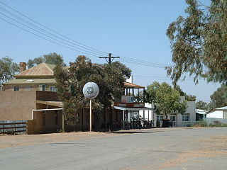
Tibooburra is a town in the far northwest of New South Wales, Australia, located 1,187 kilometres (738 mi) from the state capital, Sydney. It is most frequently visited by tourists on their way to Sturt National Park or on the way to or from Innamincka in South Australia and Birdsville in Queensland. At the 2016 census, Tibooburra had a population of 134. Although facilities in Tibooburra are quite limited, fuel, meals, and a range of accommodation options are available. All significant support services are based in Broken Hill.
Milparinka is a small settlement in north-west New South Wales, Australia, about 250 kilometres (155 mi) north of Broken Hill on the Silver City Highway. At the time of the 2016 census, Milparinka had a population of 77 people. Milparinka is on Evelyn Creek.
Tarrawingee is a locality and a ghost town in the Far West region of New South Wales, some 60 kilometres (37 mi) north of the town of Broken Hill. The town was established in 1889 to exploit a deposit of limestone needed as flux for the smelters at Broken Hill. The township grew to accommodate 400 people and facilities included a post office, two pubs, a police station, a court house and a school. In 1898, smelting moved to Port Pirie and the limestone quarry closed. Today only the stone foundations of a few buildings remain.

King Parish, New South Wales is a remote rural locality and civil parish of Evelyn County in far northwest New South Wales, Australia.

Sturt Parish is a remote civil parish of Poole County in far North West New South Wales, located at 29.433056°S 141.519722°E.

Preservation Creek is a creek in northwest New South Wales west of the town of Milparinka. The creek is 8.25 kilometres (5.13 mi) and flows from an elevation of 181 metres (594 ft) and drops to an elevation of 162 metres (531 ft). The Nuggets Creek flows into the Preservation Creek. It is a tributary of Evelyn Creek.

Mount Blackwood, New South Wales located at 29°48′37″S 141°31′10″E, is a remote rural locality and civil parish of Evelyn County in far northwest New South Wales. located at 30°04′42″S 142°45′50″E, east of the Silver City Highway . The geography of the parish is mostly the flat, arid landscape of the Channel Country. The parish has a Köppen climate classification of BWh.
Milring Parish is a remote rural locality and civil parish of Evelyn County in far northwest New South Wales. located at 29°54′29″S 141°40′53″E.
Coally is a remote rural locality and civil parish of Evelyn County, New South Wales in far northwest New South Wales located at 29°51′00″S 141°50′39″E.
Mount Wood, New South Wales is a remote civil parish of Tongowoko County, New South Wales near Milparinka, New South Wales.
Mouloonk is a remote rural locality and civil parish of Evelyn County in far northwest New South Wales. located at 30°09′04″S 141°07′08″E.

Haynes is a remote civil parish of Evelyn County in far northwest New South Wales, located at 30°24′24″S 141°04′48″E.

Booraboonara located at 31°25′02″S 141°44′53″E is a remote civil parish of Mootwingee County in far North West New South Wales.
The Parish of Essie, New South Wales is a remote civil parish of Evelyn County, New South Wales in far northwest New South Wales, located at 29.839722°S 141.134722°E, on the border with South Australia.
Parish of Paradise, New South Wales is a remote civil parish of Evelyn County, New South Wales in far northwest New South Wales. located at 29.850000°S 141.844167°E on the border with South Australia.
Scott Parish, New South Wales is a remote rural locality and civil parish of Evelyn County, New South Wales in far northwest New South Wales. located at 29°38′31″S 142°01′00″E.
Cobham Lake, when full, covers an area of around 580 hectares and is located in New South Wales, Australia. Cobham Lake is south of Milparinka between Green Lake and Salt Lake, the water is fresh and pure, reeds grow lushly and birds are in abundance. The lake is beside the Silver City Highway.
The Parish of Wydjah located at 30°00′35″S 141°37′52″ is a remote rural locality and civil parish of Evelyn County, New South Wales in far northwest New South Wales.
The Parish of Wygah, New South Wales located at 30°00′35″S 141°37′52″ is a remote rural locality and civil parish of Evelyn County, New South Wales in far northwest New South Wales.
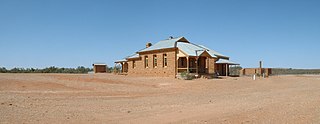
The Albert Goldfield Ruins is a heritage-listed former gold mining area on the Silver City Highway, Milparinka about 25 km south of Tibooburra, New South Wales, Australia. Surviving remnants of the larger Albert Goldfield, they were built from 1880. It was added to the New South Wales State Heritage Register on 2 April 1999.
References
- ↑ "Milparinka". The Family Hotel, Tibooburra. Archived from the original on 5 September 2009. Retrieved 5 January 2015.
- ↑ Aboriginal Heritage Archived 1 March 2018 at the Wayback Machine , Corner Country History & Heritage.
- ↑ Mining Heritage Corner Country History Archived 1 March 2018 at the Wayback Machine .
- ↑ Milparinka Heritage Precinct Archived 1 March 2018 at the Wayback Machine .
| | This Far West geography article is a stub. You can help Wikipedia by expanding it. |