Ezerets, Dobrich Province

Last updated
Ezerets
Village
Bulgaria location map.svg
Red pog.svg
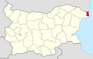
Ezerets
Location in Bulgaria
Coordinates: 43°35′42″N28°32′10″E / 43.595°N 28.536°E / 43.595; 28.536 Coordinates: 43°35′42″N28°32′10″E / 43.595°N 28.536°E / 43.595; 28.536
Country Flag of Bulgaria.svg  Bulgaria
Province Dobrich Province
Municipality Shabla
Time zone UTC+2 (EET)
  Summer (DST) UTC+3 (EEST)

Ezerets is a village in Shabla Municipality, Dobrich Province, northeastern Bulgaria. [1]

Shabla Municipality Municipality in Dobrich, Bulgaria

Shabla Municipality is a municipality (obshtina) in Dobrich Province, Bulgaria, located in the north-easternmost part of the country on the Northern Bulgarian Black Sea Coast in Southern Dobruja geographical region, bounded by Romania to the north. It is named after its administrative centre - the town of Shabla.

Dobrich Province Province in Bulgaria

Dobrich Province is a province in northeastern Bulgaria, part of Southern Dobruja geographical region. It is bounded on east by the Black Sea, on south by Varna Province, on west by Yambol & Sliven provinces, on north by Shumen & Varna provinces. It is divided into 8 municipalities. At the 2011 census, it had a population of 186,016.

Bulgaria country in Southeast Europe

Bulgaria, officially the Republic of Bulgaria, is a country in Southeast Europe. It is bordered by Romania to the north, Serbia and North Macedonia to the west, Greece and Turkey to the south, and the Black Sea to the east. The capital and largest city is Sofia; other major cities are Plovdiv, Varna and Burgas. With a territory of 110,994 square kilometres (42,855 sq mi), Bulgaria is Europe's 16th-largest country.

Ezerets Knoll on Graham Land, Antarctica is named after the village.

Ezerets Knoll

Ezerets Knoll is the narrow, mostly ice-covered ridge extending 3.35 km in west-northwest to east-southeast direction, 800 m wide and rising to 900 m in the west foothills of Bruce Plateau on Graham Coast in Graham Land, Antarctica. It surmounts Hugi Glacier to the west and its tributary Rickmers Glacier to the northeast.

Graham Land geographical object

Graham Land is the portion of the Antarctic Peninsula that lies north of a line joining Cape Jeremy and Cape Agassiz. This description of Graham Land is consistent with the 1964 agreement between the British Antarctic Place-names Committee and the US Advisory Committee on Antarctic Names, in which the name "Antarctic Peninsula" was approved for the major peninsula of Antarctica, and the names Graham Land and Palmer Land for the northern and southern portions, respectively. The line dividing them is roughly 69 degrees south.

Antarctica Polar continent in the Earths southern hemisphere

Antarctica is Earth's southernmost continent. It contains the geographic South Pole and is situated in the Antarctic region of the Southern Hemisphere, almost entirely south of the Antarctic Circle, and is surrounded by the Southern Ocean. At 14,000,000 square kilometres, it is the fifth-largest continent. For comparison, Antarctica is nearly twice the size of Australia. About 98% of Antarctica is covered by ice that averages 1.9 km in thickness, which extends to all but the northernmost reaches of the Antarctic Peninsula.

Related Research Articles

Provinces of Bulgaria

The provinces of Bulgaria are the first level administrative subdivisions of the country.

Blagoevgrad Province Province in Bulgaria

Blagoevgrad Province, also known as Pirin Macedonia is a province (oblast) of southwestern Bulgaria. It borders four other Bulgarian provinces to the north and east, to the Greek region of Macedonia to the south, and North Macedonia to the west. The province has 14 municipalities with 12 towns. Its principal city is Blagoevgrad, while other significant towns include Bansko, Gotse Delchev, Melnik, Petrich, Razlog, Sandanski, and Simitli.

Haskovo Province Province in Bulgaria

Haskovo Province is a province in southern Bulgaria, neighbouring Greece and Turkey to the southeast, comprising parts of the Thracian valley along the river Maritsa. It is named after its administrative and industrial centre - the city of Haskovo. The province embraces a territory of 5,533.3 km² that is divided into 11 municipalities with a total population, as of December 2009, of 256,408 inhabitants.

Montana Province Province in Bulgaria

Montana Province is a province in northwestern Bulgaria, bordering Serbia in the southwest and Romania in the north. It spreads its area between the Danube river and Balkan mountain. As of February 2011, the province has a population of 148,098 inhabitants, on territory of 3,635.5 km². It was named after its administrative centre the city of Montana.

Radomir (town) town

Radomir is a town and municipality in the Pernik Province of Bulgaria with a population of about 16,503.

Mezdra Place in Vratsa, Bulgaria

Mezdra is a town in northwestern Bulgaria, part of Vratsa Province. It is located on the left bank of the Iskar River just north of its gorge through the Balkan Mountains.

Sredets Place in Burgas, Bulgaria

Sredets is a town in Burgas Province in southeastern Bulgaria. It is located near Lake Mandrensko and the northern slopes of Strandzha. Sredets is the administrative centre of Sredets Municipality.

Tervel (town) Place in Dobrich, Bulgaria

Tervel is a town in northeastern Bulgaria, part of Dobrich Province. It is the administrative centre of Tervel Municipality, which lies in the westernmost part of the province. As of December 2009, the town has a population of 6,667 inhabitants.

Kiryak Hristov Shkurtov or Kiriak Shkurtov was a Bulgarian revolutionary, voivode of Internal Macedonian-Adrianople Revolutionary Organization in the region of Kostur (Kastoria), present-day Greece.

Rickmers Glacier glacier in Antarctica

Rickmers Glacier is a glacier flowing into Hugi Glacier just northwest of Ezerets Knoll, on the west coast of Graham Land. Photographed by Hunting Aerosurveys Ltd. in 1955-57, and mapped from these photos by the Falkland Islands Dependencies Survey (FIDS). Named by the United Kingdom Antarctic Place-Names Committee (UK-APC) in 1959 for W. Rickmer Rickmers, German pioneer exponent of skiing and joint author of the first English manual on skiing. He also improved the design of ice axes, introducing the characteristic shape still in use.

Kresna Municipality Municipality in Blagoevgrad, Bulgaria

Kresna Municipality is a municipality in Blagoevgrad Province in southwestern Bulgaria. The administrative center is the town of Kresna.

Ezerets is a village in Kresna Municipality, Blagoevgrad Province, Bulgaria.

Rasnik Peak

Rasnik Peak is the sharp, partly ice-covered peak rising to 900 m at the southwest extremity of Chiren Heights on Velingrad Peninsula, Graham Coast in Graham Land, Antarctica. It has steep and partly ice-free northwest and southeast slopes, and surmounts Hugi Glacier and its tributary Caulfield Glacier to the south, and Holtedahl Bay to the west.

Nauchene Nunatak

Nauchene Nunatak is the mostly ice-covered rocky ridge extending 1.2 km in northwest-southeast direction, 600 m wide and rising to 800 m in lower Rickmers Glacier in the west foothills of Bruce Plateau on Graham Coast in Graham Land, Antarctica. It is named after the settlement of Nauchene in Southeastern Bulgaria.

References

  1. Guide Bulgaria, Accessed May 23, 2010