Rennesøy is an island municipality in Rogaland county, Norway. It is located in the traditional district of Ryfylke. The administrative centre of the municipality is the village of Vikevåg. Other villages in Rennesøy include Askje and Sørbø. The municipality encompasses a number of islands on the south side of the Boknafjorden, north of the city of Stavanger.
Kvitsøy is an island municipality in Rogaland county, Norway. At only 6.29-square-kilometre (2.43 sq mi), it is the smallest municipality in Norway by area and one of the smallest by population. Kvitsøy is located in the traditional district of Ryfylke. The administrative centre of the municipality is the village of Ydstebøhamn on the island of Kvitsøy. The municipality is an archipelago located at the entrance to the large Boknafjorden. It sits about 2 nautical miles northwest of the mainland Stavanger peninsula. There are plans for the Rogfast tunnel to eventually connect Kvitsøy to the mainland road network.

Tysvær is a municipality in Rogaland county, Norway. It is part of the Haugalandet region. The municipality is located on the Haugalandet peninsula on the northern side of the Boknafjorden, just east of the towns of Kopervik and Haugesund. The administrative centre of the municipality is the village of Aksdal. Other villages in the municipality include Dueland, Førre, Grinde, Hervik, Hindaråvåg, Nedstrand, Skjoldastraumen, Susort, Tysvær, and Yrke.

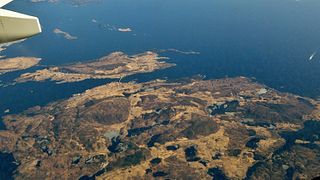
Boknafjord or Boknafjorden is a fjord located in Rogaland county, Norway. The huge fjord lies between the cities Stavanger and Haugesund, and the main part of the fjord is shared between the municipalities of Kvitsøy, Rennesøy, Finnøy, Tysvær, Bokn, and Karmøy. There are dozens of smaller fjords that branch off the main part of the fjord, reaching most municipalities in the county. At its longest, the Boknafjord reaches about 96 kilometres (60 mi) into the mainland at the innermost point of the Hylsfjorden. Other notable branches include the Saudafjorden, Sandsfjorden, Vindafjorden, Hervikfjorden, Førresfjorden, Erfjorden, Jøsenfjorden, Årdalsfjorden, Idsefjorden, Høgsfjorden, Lysefjorden, and Gandsfjorden.

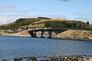
Karmsund is a strait located in Rogaland county, Norway. The 30-kilometre (19 mi) long strait divides the island of Karmøy on the west and the mainland of Norway and island of Vestre Bokn in the east. The strait runs through the municipalities of Haugesund, Karmøy, and Bokn. The town of Haugesund lies at the northern end of the strait and the town of Kopervik lies in the central part of the strait, and the village of Skudeneshavn lies near the southern end where the strait flows into the Boknafjorden. The Karmsund Bridge, a part of the European route E134 highway, links Karmøy to the mainland. The bridge was completed in 1955. The small islands of Vibrandsøy, Risøy, and Hasseløy lie in the strait at the northern end, just off shore from the town of Haugesund.
Skudenes is a former municipality in Rogaland county, Norway. It was part of the traditional district of Haugaland. The municipality existed from 1838 until its dissolution in 1965. Today the area is part of the municipalities of Bokn and Karmøy. Skudenes originally encompassed the southern part of the island of Karmøy and the three islands to the east: Vestre Bokn, Austre Bokn, and Ognøya. In 1849, the three smaller islands were separated to form Bokn municipality.
Vestre Moland is a former municipality in Aust-Agder county, Norway. The administrative centre of the municipality was the village of Møglestu where the Vestre Moland Church is located. The 103-square-kilometre (40 sq mi) municipality existed from 1838 until 1962 when it was merged into the municipality of Lillesand. Today, the area of Vestre Moland covers the northern part of the present-day municipality of Lillesand.
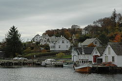
Judaberg is the administrative centre of Finnøy municipality in Rogaland county, Norway. The village is located on the eastern shore of the island of Finnøy. The island is located on the south side of the Boknafjorden, northeast of the large city of Stavanger.

Ydstebøhamn or Ystabøhamn is the administrative centre of Kvitsøy municipality in Rogaland county, Norway. The village is located on the southern shore of the island of Kvitsøy. The village has a ferry quay which receives regular ferries from the town of Skudeneshavn on the island of Karmøy across the Boknafjorden to the north, and to the village of Mekjarvik in Randaberg municipality across the Kvitsøyfjorden on the mainland to the south. The planned Rogfast undersea tunnel will connect Kvitsøy to the mainland to the north and south as part of the government's goal of providing a ferry-free European route E39 highway along the west coast of Norway.

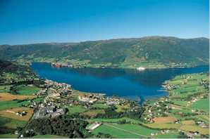
Hjelmelandsvågen is the administrative centre of Hjelmeland municipality, Norway. The village is located on the south side of the mouth of the Jøsenfjorden. The 0.67-square-kilometre (170-acre) village has a population (2015) of 558, giving the village a population density of 833 inhabitants per square kilometre (2,160/sq mi).

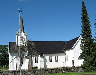
Skjold is a village in Vindafjord municipality in Rogaland county, Norway. The village is located at the northern end of the Skjoldafjorden, along the European route E134 highway, about 25 kilometres (16 mi) northeast of the town of Haugesund. Skjold Church is located in the village. The village was the administrative centre of the old municipality of Skjold which existed from 1838 until 1965.

Hommersåk is a village in Sandnes municipality in Rogaland county, Norway. The village is located in the borough of Riska in the northern part of the municipality. It is situated about 12 kilometres (7.5 mi) northeast of the city centre of Sandnes, along the shore of the Riskafjorden, an arm off the main Gandsfjorden. The 2.14-square-kilometre (530-acre) village has a population (2015) of 6,312; giving the village a population density of 2,950 inhabitants per square kilometre (7,600/sq mi).
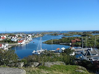
Vestre Bokn is an island in Bokn municipality in Rogaland county, Norway. The 36-square-kilometre (14 sq mi) island is the main island of the municipality. It lies on the northern side of the Boknafjorden at the southern end of the Karmsundet strait. Vestre Bokn lies between the islands of Karmøy and Austre Bokn and Ognøya. The main population centre on the island is the village of Føresvik, the administrative centre of the whole municipality. There are about 661 inhabitants on the island.

Åmøy is an island that is divided between Rennesøy and Stavanger municipalities in Rogaland county, Norway. The 5.3-square-kilometre (2.0 sq mi) island lies just north of the city of Stavanger in a group of islands. The islands of Sokn and Bru both lie to the west of Åmøy and the islands of Mosterøy and Rennesøy lie to the north, and the island of Hidle lies to the east.
Ølensjøen or Ølen is the administrative centre of Vindafjord municipality in Rogaland county, Norway. The village is located at the southern end of the Ølsfjorden, along the European route E134 highway, just east of the village of Ølensvåg. The 1.0-square-kilometre (250-acre) village has a population (2014) of 1,077; giving the village a population density of 1,077 inhabitants per square kilometre (2,790/sq mi). It is the largest urban area in the municipality.

Ognøya or Ogn is an island in Bokn municipality in Rogaland county, Norway. The 5.5-square-kilometre (2.1 sq mi) island lies between the mainland and the islands of Austre Bokn and Vestre Bokn. The islands are connected by a series of bridges as part of the European route E39 highway. The industrial area of Kårstø lies just north of Ognøya on the mainland.
Austre Bokn is an island in Bokn municipality in Rogaland county, Norway. The 7.5-square-kilometre (2.9 sq mi) island lies on the northern side of the Boknafjorden between the islands of Ognøya and Vestre Bokn. It's connected to the other two islands and to the mainland by a series of bridges along the European route E39 highway. Both islands are separated from Austre Bokn by very small channels that are only about 250 to 350 metres wide.

Vikevåg is the administrative centre of Rennesøy municipality in Rogaland county, Norway. The village is located on the south side of the island of Rennesøy. The northern end of the Mastrafjord Tunnel lies at Vikevåg. The tunnel is part of the European route E39 highway. Hausken Church is located in Vikevåg.