
Snowdonia or Eryri, is a mountainous region in northwestern Wales and a national park of 823 square miles (2,130 km2) in area. It was the first to be designated of the three national parks in Wales, in 1951.

In oceanography, geomorphology, and geoscience, a shoal is a natural submerged ridge, bank, or bar that consists of, or is covered by, sand or other unconsolidated material and rises from the bed of a body of water to near the surface. It often refers to those submerged ridges, banks, or bars that rise near enough to the surface of a body of water as to constitute a danger to navigation. Shoals are also known as sandbanks, sandbars, or gravelbars. Two or more shoals that are either separated by shared troughs or interconnected by past or present sedimentary and hydrographic processes are referred to as a shoal complex.

Longshore drift from longshore current is a geological process that consists of the transportation of sediments along a coast parallel to the shoreline, which is dependent on the angle incoming wave direction. Oblique incoming wind squeezes water along the coast, and so generates a water current which moves parallel to the coast. Longshore drift is simply the sediment moved by the longshore current. This current and sediment movement occur within the surf zone. The process is also known as littoral drift.

Holderness is an area of the East Riding of Yorkshire, on the north-east coast of England. An area of rich agricultural land, Holderness was marshland until it was drained in the Middle Ages. Topographically, Holderness has more in common with the Netherlands than with other parts of Yorkshire. To the north and west are the Yorkshire Wolds. Holderness generally refers to the area between the River Hull and the North Sea. The Prime Meridian passes through Holderness just to the east of Patrington and through Tunstall to the north.

Barmouth is a seaside town and community in the county of Gwynedd, northwestern Wales, lying on the estuary of the Afon Mawddach and Cardigan Bay. Located in the historic county of Merionethshire, the Welsh form of the name is derived from aber (estuary) and the river's name, "Mawddach". The English form of the name is a corruption of the earlier Welsh form Abermawdd. The community includes the villages of Llanaber, Cutiau, and Caerdeon.

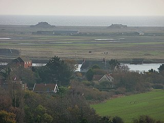
Fairbourne is a seaside village in Gwynedd, Wales. Located on the coast of Barmouth Bay in Arthog community, to the south of the estuary of the River Mawddach, it is surrounded by Snowdonia National Park. It is in an area that had been listed by Gwynedd Council for managed retreat due to rising sea levels.

Cardigan Bay is a large inlet of the Irish Sea, indenting the west coast of Wales between Bardsey Island, Gwynedd in the north, and Strumble Head, Pembrokeshire at its southern end. It is the largest bay in Wales.

The Afon Mawddach is a river in Gwynedd, Wales, which has its source in a wide area SH820300 north of Dduallt in Snowdonia. It is 28 miles (45 km) in length, and is much branched; many of the significant tributaries are of a similar size to the main river. The catchment area is bounded to the east by the Aran Fawddwy massif and to the west and north by the Harlech dome which forms a watershed just south of Llyn Trawsfynydd.
Orford Ness is a cuspate foreland shingle spit on the Suffolk coast in Great Britain, linked to the mainland at Aldeburgh and stretching along the coast to Orford and down to North Weir Point, opposite Shingle Street. It is divided from the mainland by the River Alde, and was formed by longshore drift along the coast. The material of the spit comes from places further north, such as Dunwich. Near the middle point of its length, at the foreland point or 'Ness', once stood Orfordness Lighthouse, demolished in summer 2020 owing to the encroaching sea. In the name of the lighthouse, 'Orfordness' is written as one word.

The Fairbourne Railway is a 12+1⁄4 in gauge miniature railway running for 2 miles (3.2 km) from the village of Fairbourne on the Mid-Wales coast, alongside the beach to the end of a peninsula at Barmouth Ferry railway station, where there is a connection with the Barmouth Ferry across the Mawddach estuary to the seaside resort of Barmouth.

Coastal geography is the study of the constantly changing region between the ocean and the land, incorporating both the physical geography and the human geography of the coast. It includes understanding coastal weathering processes, particularly wave action, sediment movement and weather, and the ways in which humans interact with the coast.
Minsmere is a place in the English county of Suffolk. It is located on the North Sea coast around 3.5 miles (5.6 km) north of Leiston and 1.5 miles (2.4 km) south-east of Westleton within the Suffolk Coast and Heaths AONB. It is the site of the Minsmere RSPB reserve and the original site of Leiston Abbey.
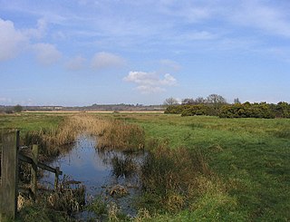
Blakeney Point is a national nature reserve situated near to the villages of Blakeney, Morston and Cley next the Sea on the north coast of Norfolk, England. Its main feature is a 6.4 km (4 mi) spit of shingle and sand dunes, but the reserve also includes salt marshes, tidal mudflats and reclaimed farmland. It has been managed by the National Trust since 1912, and lies within the North Norfolk Coast Site of Special Scientific Interest, which is additionally protected through Natura 2000, Special Protection Area (SPA), International Union for Conservation of Nature (IUCN) and Ramsar listings. The reserve is part of both an Area of Outstanding Natural Beauty (AONB), and a World Biosphere Reserve. The Point has been studied for more than a century, following pioneering ecological studies by botanist Francis Wall Oliver and a bird ringing programme initiated by ornithologist Emma Turner.
The Aberystwith and Welsh Coast Railway was a standard gauge railway company, running a line along the west coast of Wales.
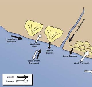
Sedimentary budgets are a coastal management tool used to analyze and describe the different sediment inputs (sources) and outputs (sinks) on the coasts, which is used to predict morphological change in any particular coastline over time. Within a coastal environment the rate of change of sediment is dependent on the amount of sediment brought into the system versus the amount of sediment that leaves the system. These inputs and outputs of sediment then equate to the total balance of the system and more than often reflect the amounts of erosion or accretion affecting the morphology of the coast.

The Barmouth Ferry provides a passenger service across the River Mawddach in Gwynedd county, north Wales. There are currently two ferry operators on the harbour. The service usually operates from April to October.

Bideford Bay, also known as Barnstaple Bay and often shown on maps as Barnstaple or Bideford Bay, is a large area of water on the northwest coast of Devon in South West England, at the southwestern end of the Bristol Channel where it joins the Celtic Sea. The bay extends from Hartland Point in the southwest to Baggy point the northeast, and is partly sheltered by the island of Lundy, 12 miles (19 km) offshore. It takes its alternative names from the towns of Bideford and Barnstaple, located respectively on the rivers Torridge and Taw which flow into the bay. The alternative spelling Barnstable Bay, in use long after that spelling became obsolete for the town, is also sometimes seen.
Hurst Spit is a one-mile-long (1.6 km) shingle bank near the village of Keyhaven, at the western end of the Solent, on the south coast of England. The spit shelters an area of saltmarsh and mudflats known as Keyhaven and Pennington marshes. At the end of the spit is Hurst Castle, an artillery fortress originally built on the orders of King Henry VIII, and much enlarged in the 19th century. Hurst Point Lighthouse was built on the end of Hurst Spit in the 1860s.
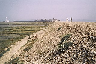
Barmouth Bay is a bay in Gwynedd on the west coast of Wales, forming a part of the much larger Cardigan Bay. The coast fronting onto the bay is within the Snowdonia National Park at its northern and southern extremities but the coastal town of Barmouth and village of Fairbourne at the back of the bay are excluded from the designated area. Inland of the bay is the sandy Mawddach estuary, through which the tidal channel of the river winds before emptying into the bay beyond Fairbourne Spit, a shingle promontory stretching north from Fairbourne. A sandbank known as 'The Bar' guards the entrance to this channel from Cardigan Bay. The Cambrian Coast Line runs along the narrow coastal strip at the back of the bay, crossing the Mawddach via Barmouth Bridge which also carries the Wales Coast Path.
