State Route 520 (SR 520) is a state highway and freeway in the Seattle metropolitan area, part of the U.S. state of Washington. It runs 13 miles (21 km) from Seattle in the west to Redmond in the east. The freeway connects Seattle to the Eastside region of King County via the Evergreen Point Floating Bridge on Lake Washington. SR 520 intersects several state highways, including Interstate 5 (I-5) in Seattle, I-405 in Bellevue, and SR 202 in Redmond.

The Evergreen Point Floating Bridge, officially the Governor Albert D. Rosellini Bridge, and commonly called the SR 520 Bridge or 520 Bridge, was a floating bridge in the U.S. state of Washington that carried State Route 520 across Lake Washington, connecting Medina with the Montlake neighborhood of Seattle.

State Route 99 (SR 99), also known as the Pacific Highway, is a state highway in the Seattle metropolitan area, part of the U.S. state of Washington. It runs 49 miles (79 km) from Fife to Everett, passing through the cities of Federal Way, SeaTac, Seattle, Shoreline, and Lynnwood. The route primarily follows arterial streets, including Aurora Avenue, and has several freeway segments, including the tolled SR 99 Tunnel in Downtown Seattle. SR 99 was officially named the William P. Stewart Memorial Highway by the state legislature in 2016, after a campaign to replace an unofficial moniker honoring Confederate president Jefferson Davis.

The University Bridge is a double-leaf bascule bridge in Seattle, Washington that carries Eastlake Avenue traffic over Portage Bay between Eastlake to the south and the University District to the north. It opened on July 1, 1919, and was extensively rebuilt from 1932 to 1933. It is included in the National Register of Historic Places.

The Aurora Bridge is a cantilever and truss bridge in Seattle, Washington, United States. It carries State Route 99 over the west end of Seattle's Lake Union and connects Queen Anne and Fremont. The bridge is located just east of the Fremont Cut, which itself is spanned by the Fremont Bridge.
The Alaskan Way Viaduct was an elevated freeway in Seattle, Washington, United States, that carried a section of State Route 99. The double-decked freeway ran north–south along the city's waterfront for 2.2 miles (3.5 km), east of Alaskan Way and Elliott Bay, and traveled between the West Seattle Freeway in SoDo and the Battery Street Tunnel in Belltown.

The Third Lake Washington Bridge, officially the Homer M. Hadley Memorial Bridge, is a floating bridge in the Seattle metropolitan area of the U.S. state of Washington. It is one of the Interstate 90 floating bridges, carrying the westbound lanes of Interstate 90 across Lake Washington between Mercer Island and Seattle. The floating bridge is the fifth-longest of its kind in the world, at 5,811 feet.

Interstate 405 (I-405) is a north–south auxiliary Interstate Highway serving the Seattle region of Washington, United States. It bypasses Seattle east of Lake Washington, traveling through the Eastside area of King and Snohomish counties, providing an alternate route to I-5. The 30-mile (48 km) freeway serves the cities of Renton, Bellevue, Kirkland, and Bothell. I-405 terminates at I-5 in Tukwila and Lynnwood, and also intersects several major highways, including SR 167, I-90, SR 520, and SR 522.

The 1 Line, formerly Central Link, is a light rail line in Seattle, Washington, United States, and part of Sound Transit's Link light rail system. It serves 23 stations in King and Snohomish counties, traveling 33 miles (53 km) between Lynnwood City Center and Angle Lake stations. The line connects Lynnwood, Mountlake Terrace, Shoreline, the University District, Downtown Seattle, the Rainier Valley, and Seattle–Tacoma International Airport. The 1 Line carried over 26 million total passengers in 2023, with an average of nearly 80,000 daily passengers on weekdays. It runs for 20 hours per day on weekdays and Saturdays, with headways as low as six minutes during peak hours, and reduced 18-hour service on Sundays and holidays.

The West Seattle Bridge, officially the Jeanette Williams Memorial Bridge, is a cantilevered segmental bridge that serves as the primary connection between West Seattle and important highways such as State Route 99, the Spokane Street Viaduct, and Interstate 5. It was built between 1981 and 1984 after the previous bascule bridge was deemed inoperable as a result of being struck by the freighter Antonio Chavez in 1978.

The South Lake Union Streetcar, officially the South Lake Union Line, is a streetcar route in Seattle, Washington, United States, forming part of the Seattle Streetcar system. It travels 1.3 miles (2.1 km) and connects Downtown Seattle to the South Lake Union neighborhood on Westlake Avenue, Terry Avenue, and Valley Street. The South Lake Union Streetcar was the first modern line to operate in Seattle, beginning service on December 12, 2007, two years after a separate heritage streetcar ceased operations.

Interstate 90 (I-90), designated as the American Veterans Memorial Highway, is a transcontinental Interstate Highway that runs from Seattle, Washington, to Boston, Massachusetts. It crosses Washington state from west to east, traveling 298 miles (480 km) from Seattle across the Cascade Mountains and into Eastern Washington, reaching the Idaho state line east of Spokane. I-90 intersects several of the state's other major highways, including I-5 in Seattle, I-82 and U.S. Route 97 (US 97) near Ellensburg, and US 395 and US 2 in Spokane.

Interstate 5 (I-5) is an Interstate Highway on the West Coast of the United States that serves as the region's primary north–south route. It spans 277 miles (446 km) across the state of Washington, from the Oregon state border at Vancouver, through the Puget Sound region, to the Canadian border at Blaine. Within the Seattle metropolitan area, the freeway connects the cities of Tacoma, Seattle, and Everett.
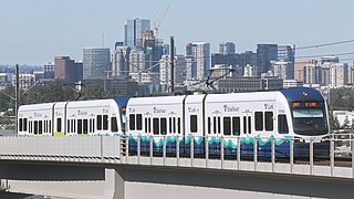
The 2 Line, also known as the East Link Extension, is a light rail line serving the Eastside region of the Seattle metropolitan area in the U.S. state of Washington. It is part of Sound Transit's Link light rail system and runs for 6.6 miles (10.6 km) in the cities of Bellevue and Redmond. The initial segment serves eight stations between South Bellevue and Redmond Technology stations and opened on April 27, 2024. The full line is scheduled to open in 2025 and is planned to span 18 miles (29 km) from west to east and serve twelve stations in Downtown Seattle, Mercer Island, Bellevue, and Redmond. The 2 Line will continue through the Downtown Seattle Transit Tunnel and share stations with the 1 Line through to Lynnwood City Center station.

Northgate is a light rail and bus station in the Northgate neighborhood of Seattle, Washington, United States, and part of 1 Line on Sound Transit's Link light rail system. The transit center, located adjacent to the Northgate Mall, has four bus bays served by 22 routes. The station also has parking for 1,475 vehicles.
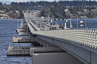
The Evergreen Point Floating Bridge, also known as the 520 Bridge and officially the Governor Albert D. Rosellini Bridge, is a floating bridge that carries Washington State Route 520 across Lake Washington from Seattle to its eastern suburbs. The 7,710-foot-long (2,350 m) floating span is the longest floating bridge in the world, as well as the world's widest measuring 116 feet (35 m) at its midpoint. It is a toll bridge and uses electronic collection.
Mercer Street is a major east–west thoroughfare in the Lower Queen Anne and South Lake Union neighborhoods of Seattle, Washington. It travels 2 miles (3.2 km) and connects Elliott Avenue to the west and Interstate 5 to the east, serving as one of several downtown exits on the freeway. The street carries an average weekday volume of 38,000 vehicles on its central section.
Denny Way is an east–west arterial street in downtown Seattle, Washington, United States. It forms the northern end of the Belltown street grid as well as the boundaries of Belltown, Lower Queen Anne, South Lake Union, Denny Triangle, and Cascade. The street continues east through Capitol Hill to Madrona as a minor neighborhood street, ending near Madrona Park on Lake Washington.

Westlake Avenue is a major street in Seattle, Washington, connecting Downtown Seattle to the neighborhoods of South Lake Union, Westlake and northeastern Queen Anne. The street runs north–south along the west side of Lake Union for 2.5 miles (4.0 km) from McGraw Square to the Fremont Bridge.

