
Palm Island is a locality consisting of an island group of 16 islands, split between the Shire of Hinchinbrook and the Aboriginal Shire of Palm Island, in Queensland, Australia. The locality coincides with the geographical entity known as the Palm Island group, also known as the Greater Palm group, originally named the Palm Isles.
Fantome Island is one of the islands in the Palm Island group. It is neighboured by Great Palm Island and is 65 km (40 mi) north-east of Townsville, Queensland on the east coast of Australia. The island is small with an area of 7.8 km2 (3.01 sq mi) and is surrounded by a fringing reef. The Djabugay (Aboriginal) name for this island is Eumilli Island.
Curacoa Island is one of the islands in the Palm Islands group off the coast of Queensland, Australia. The nearest island is Great Palm Island, after which the group is named. Curacoa Island is uninhabited.
Esk Island is one of the small uninhabited islands in the Palm Islands group. The nearest island is Falcon Island. The Aboriginal name for the island is Soopun. Along with nine of the other islands within the Palm Islands group, it falls under the local government area of the Aboriginal Shire of Palm Island.
Brisk Island is an island in the Great Palm Island group. The nearest island is Great Palm Island, after which the group is named. The Nyawaygi name for Brisk Island is Culgarool. Along with nine of the other islands within the Palm Islands group, it falls under the local government area of the Aboriginal Shire of Palm Island.

Eclipse Island, or Garoogubbee, once known as Punishment Island, is one of the small islands in the Palm Islands group off the coast of Queensland, Australia. The nearest island is Great Palm Island, after which the group is named. Along with nine of the other islands within the Palm Islands group, it falls under the local government area of the Aboriginal Shire of Palm Island.

Seisia is a coastal town and a locality in the Northern Peninsula Area Region, Queensland, Australia. In the 2016 census, Seisia had a population of 260 people.

Pormpuraaw is a coastal town and a locality in the Aboriginal Shire of Pormpuraaw, Queensland, Australia. Pormpuraaw is an Aboriginal community situated on the west coast of Cape York Peninsula approximately halfway between Karumba and Weipa on the Edward River. It is 650 kilometres (400 mi) by road from Cairns. Pormpuraaw currently has a 4-man police station.

Mapoon is a coastal town in the Aboriginal Shire of Mapoon and a locality split between the Aboriginal Shire of Mapoon and the Shire of Cook in Queensland, Australia. In the 2016 census, Mapoon had a population of 317 people.
Havannah Island is one of the islands in the Palm Island group. The nearest island is Great Palm Island, after which the group is named. Havannah Island is the southernmost island in the group, and uninhabited. Along with nine of the other islands within the Palm Islands group, it falls under the local government area of the Aboriginal Shire of Palm Island.
Fly Island is a tiny uninhabited island in the Great Palm Island group. Along with nine of the other islands within the Palm Islands group, it falls under the local government area of the Aboriginal Shire of Palm Island.
Hammond Island is an island with a town of the same name, in the Torres Strait, Queensland, Australia. It is the only island within the locality of Keriri Island within the local government area of Torres Strait Island Region.

Moa Island, also called Banks Island, is an island of the Torres Strait Islands archipelago that is located 40 kilometres (25 mi) north of Thursday Island in the Banks Channel of Torres Strait, Queensland, Australia. It is also a locality within the Torres Strait Island Region local government area. This island is the largest within the "Near Western" group. It has two towns, Kubin on the south-west coast and St Pauls on the east coast, which are connected by bitumen and a gravel road. In the 2016 census, Moa Island had a population of 448 people.

Coconut Island, Poruma Island, or Puruma in the local language, is an island in the Great North East Channel near Cumberland Passage, Torres Strait, Queensland, Australia. One of the Torres Strait Islands, Coconut Island is 130 kilometres (81 mi) northeast of Thursday Island. Administratively, Coconut Island is a town and Poruma Island is the locality within the Shire of Torres.

The Shire of Cook is a local government area in Far North Queensland, Australia. The Shire covers most of the eastern and central parts of Cape York Peninsula, the most northerly section of the Australian mainland.
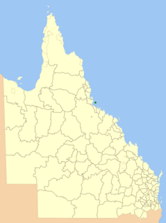
The Aboriginal Shire of Palm Island is a special local government area of Queensland, Australia, managed by the Palm Island Aboriginal Shire Council under a Deed of Grant in Trust granted to the community on 27 October 1986. The local council was previously the Palm Island Community Council, which had far fewer powers. The shire is located on the Palm Island group, off the north Queensland coast near the city of Townsville.

The Aboriginal Shire of Doomadgee is a special local government area in North West Queensland, Queensland, Australia. It is managed under a Deed of Grant in Trust under the Local Government Act 2004.
A Deed of Grant in Trust (DOGIT) is the name for a system of community-level land trust established in Queensland to administer former Aboriginal reserves and missions. They came about through the enactment by the Queensland Government of the Community Services Act 1984 and Community Services (Aborigines) Act 1984 in 1984, allowing community councils to be created to own and administer former Aboriginal reserves or missions under a Deed of Grant in Trust). The trusts are governed by local representatives who are elected every three years to councils called Incorporated Aboriginal Councils. These councils have the power to pass by-laws, appoint police for the community, and are responsible for maintaining housing and infrastructure, running the Community Development Employment Program and issuing hunting, fishing and camping permits. As such, they work much like a local government, but are different in character as they own the land they administer on behalf of the community.
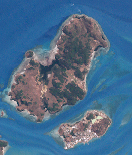
Great Palm Island, usually known as Palm Island, is the largest island in the Palm Islands group off Northern Queensland, Australia. It is known for its Aboriginal community, the legacy of an Aboriginal reserve, the Palm Island Aboriginal Settlement. The original inhabitants of the island were the Manbarra people, also known as the Wulgurukaba, who were removed to the mainland by the Queensland Government in the 1890s. The island is also sometimes referred to as Bwgcolman, which is the name given to the Aboriginal and Torres Strait Islander people from disparate groups who were deported from many areas of Queensland to the reserve in 1918, and their descendants.

Palm Island Aboriginal Settlement, later officially known as Director of Native Affairs Office, Palm Island and also known as Palm Island Aboriginal Reserve, Palm Island mission and Palm Island Dormitory, was an Aboriginal reserve and penal settlement on Great Palm Island, the main island in the Palm Island group in North Queensland, Australia. It was the largest and most punitive reserve in Queensland.
