A waterfall is an area where water flows over a vertical drop or a series of steep drops in the course of a stream or river. Waterfalls also occur where meltwater drops over the edge of a tabular iceberg or ice shelf.

Corrieshalloch Gorge is a gorge situated about 20 km south of Ullapool, close to the junction of the A832 and A835 roads near Braemore in the Scottish Highlands. The gorge is approximately 1.5 km long, 60 m deep, and 10 m wide at its lip. The Abhainn Droma flows through Corrieshalloch, below which the landscape opens out into a broad, flat-bottomed glacial trough at the head of Loch Broom.

Aignish is located northwest of Knock and east of Stornoway on the east coast of the Isle of Lewis, in the Outer Hebrides, Scotland. The township is at the island side of the isthmus connecting to the Eye peninsula. Aignish is within the parish of Stornoway, and is situated on the A866 between Stornoway and Portnaguran.

Queenslie is a district in the Scottish city of Glasgow.
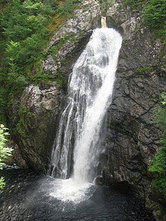
The Fall of Foyers is a waterfall on the River Foyers, which feeds Loch Ness, in Highland, Scotland, United Kingdom.

Edinample Castle is a late 16th-century tower house on the southern shores of Loch Earn near Balquhidder in the Stirling council area of Scotland. It was designated as a Category A listed building in 1971.
Canmore is an online database of information on over 320,000 archaeological sites, monuments, and buildings in Scotland. It was begun by the Royal Commission on the Ancient and Historical Monuments of Scotland. Historic Environment Scotland has maintained it since 2015. The Canmore database is part of the National Record of the Historic Environment, formerly the National Monuments Record of Scotland and contains around 1.3 million catalogue entries. It includes marine monuments and designated official wreck sites, such as the wreck of HMS Pheasant (1916).

Shulishader is a small village with a population of around 120 people in Point, Outer Hebrides on the Isle of Lewis, Scotland. Located on the north-western side of the Eye Peninsula, it overlooks Broad Bay. Most of the village is over 60m above sea level, affording excellent views across the bay and northern Lewis, though the land falls gently towards the sea before ending in small cliffs. There are several small, difficult to access, sandy beaches, and a small cove on the coastline. The cove is accessible via 88 dilapidated steps, and contains a pebble peach, some natural caves and a concrete structure once used for boat moorings above the high tide line.

Kintail is an area of mountains in the Northwest Highlands of Scotland, located in the Highland Council area. It consists of the mountains to the north of Glen Shiel and the A87 road between the heads of Loch Duich and Loch Cluanie; its boundaries, other than Glen Shiel, are generally taken to be the valleys of Strath Croe and Gleann Gaorsaic to the north and An Caorann Mòr to the east. Although close to the west coast the mountains lie on the main east–west watershed of Scotland, as the northern side of Kintail drains via Glen Affric to the east coast.
Rouken Glen Park is a public park in Thornliebank, to the south-west of Glasgow, Scotland.

The Bonnington Pavilion or Hall of Mirrors, now a ruin, is situated in the grounds of the old estate of Bonnington, near New Lanark, overlooking Corra Linn falls on the River Clyde in Lanarkshire, Scotland. Alternative names are the Corra Linn Pavilion and the Falls of Clyde summerhouse. It is said to have been the first Camera obscura built in Scotland. The name comes from the Gaelic 'currach', a marshy place. A legend gives 'Cora' as a daughter of King Malcolm II, who leapt to her death here whilst trying to escape imagined danger.

The Teviot Falls is a plunge waterfall in the Darling Downs region of Queensland, Australia.

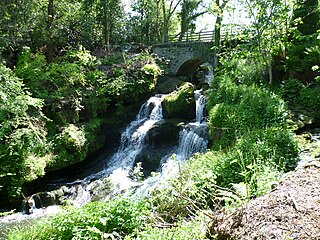
Talla Water is a river in the Scottish Borders area of Scotland, near Tweedsmuir. It feeds the Talla Reservoir, and is a tributary of the River Tweed. Above the reservoir are a series of waterfalls known as the Talla Linns.

The Clyde Valley Woodlands National Nature Reserve (NNR) comprises six separate woodland sites in the Clyde Valley region of South Lanarkshire, Scotland. These six sites are located along a 12 km section of the River Clyde and its tributaries, and lie close to built-up areas such as Hamilton and Lanark on the southern outskirts of Greater Glasgow. The sites can be easily accessed by about two million people living in the surrounding urban areas, making the reserve unique amongst Scotland's NNRs, most of which tend to be located in more remote areas. The six sites are:

Corra Castle is a ruined 16th-century castle within the Corehouse Estate near New Lanark, Scotland. It overlooks Corra Linn, one of the four waterfalls which make up the Falls of Clyde. In 1967 it became a scheduled monument.

Calderglen Country Park is a country park in the Scottish town of East Kilbride. It is situated along the eastern edge of the town and is its principle greenspace and recreation area. The visitor centre and adjoining facilities centre on the 17th century Torrance House which is a Category A listed building, and the remains of its adjoining landscaped policies.

Rosshall is an area in the south-west of Glasgow, Scotland, within the Cardonald ward of Glasgow City Council. It has a fairly isolated location, with the White Cart Water forming a border to the south and east, the Paisley Canal Line railway to the north, and open fields to the west that form a short green belt between Glasgow and the large town of Paisley – the nearest building 500 yards (460 m) to the west, Rosshall Mains Farm, falls under Paisley administration rather than Glasgow.