
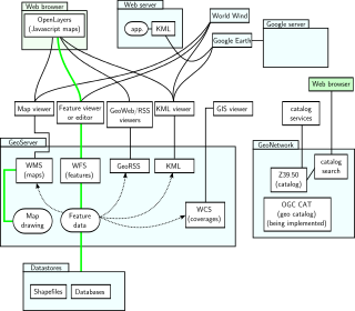
Family tree mapping is the process of geocoding places in family tree files to produce geospatial data suitable for viewing with a virtual globe or 2D mapping program.
Family tree mapping is the process of geocoding places in family tree files to produce geospatial data suitable for viewing with a virtual globe or 2D mapping program.
The availability of several free applications for viewing geographic data has led to a growing interest in the use of this technology by genealogists and family history researchers.
The ability to share keyhole markup language (KML) files through sites such as Google Maps means that researchers can find matches based on geographic location rather than just a place name.
Genealogy software that can be used for family tree mapping include: [1]
Utility applications that can be used for family tree mapping include:

NASA WorldWind is an open-source virtual globe. It was first developed by NASA in 2003 for use on personal computers and then further developed in concert with the open source community since 2004. As of 2017, a web-based version of WorldWind is available online. An Android version is also available.
Google Earth is a computer program, formerly known as Keyhole EarthViewer, that renders a 3D representation of Earth based primarily on satellite imagery. The program maps the Earth by superimposing satellite images, aerial photography, and GIS data onto a 3D globe, allowing users to see cities and landscapes from various angles. Users can explore the globe by entering addresses and coordinates, or by using a keyboard or mouse. The program can also be downloaded on a smartphone or tablet, using a touch screen or stylus to navigate. Users may use the program to add their own data using Keyhole Markup Language and upload them through various sources, such as forums or blogs. Google Earth is able to show various kinds of images overlaid on the surface of the earth and is also a Web Map Service client. Recently Google has revealed that Google Earth now covers more than 98 percent of the world, and has captured 10 million miles of Street View imagery, a distance that could circle the globe more than 400 times.
Keyhole Markup Language (KML) is an XML notation for expressing geographic annotation and visualization within two-dimensional maps and three-dimensional Earth browsers. KML was developed for use with Google Earth, which was originally named Keyhole Earth Viewer. It was created by Keyhole, Inc, which was acquired by Google in 2004. KML became an international standard of the Open Geospatial Consortium in 2008. Google Earth was the first program able to view and graphically edit KML files, but other projects such as Marble have added KML support.
Family Tree Maker is genealogy software for Windows and Mac that allows the researcher to keep track of information collected during research and to create reports, charts, and books containing that information. The software was originally developed by Kenneth Hess of Banner Blue Software, which was purchased by Broderbund in 1995. It passed through the hands of The Learning Company, Mattel, and others before coming under its current ownership.
Design Web Format (DWF) is a file format developed by Autodesk for the efficient distribution and communication of rich design data to anyone who needs to view, review, or print design files. Because DWF files are highly compressed, they are smaller and faster to transmit than design files, without the overhead associated with complex CAD drawings. With DWF functionality, publishers of design data can limit the specific design data and plot styles to only what they want recipients to see and can publish multisheet drawing sets from multiple AutoCAD drawings in a single DWF file. They can also publish 3D models from most Autodesk design applications.

A point of interest (POI) is a specific point location that someone may find useful or interesting. An example is a point on the Earth representing the location of the Eiffel Tower, or a point on Mars representing the location of its highest mountain, Olympus Mons. Most consumers use the term when referring to hotels, campsites, fuel stations or any other categories used in modern automotive navigation systems.
Pennsylvania Spatial Data Access (PASDA) is Pennsylvania's official public access geospatial information clearinghouse. PASDA serves as Pennsylvania's node on the National Spatial Data Infrastructure (NSDI). PASDA is a cooperative effort of the Pennsylvania Geospatial Technologies Office of the Office of Information Technology and the Pennsylvania State University Institutes of Energy and the Environment (PSIEE).
Reunion is genealogy software made by Leister Productions, Inc., a privately held firm established by Frank Leister in 1984 located in Mechanicsburg, Pennsylvania. The company operates as a genealogy software developer exclusively for macOS and iOS. Reunion was initially a Macintosh application, programmed in Apple's HyperCard. Version 4 was available for Windows and Macintosh until the Windows version was sold to Sierra in 1997.
ATLAS.ti is a computer program used mostly, but not exclusively, in qualitative research or qualitative data analysis.
GPSBabel is a cross-platform, free software to transfer routes, tracks, and waypoint data to and from consumer GPS units, and to convert between over a hundred types of GPS data formats. It has a command-line interface and a graphical interface for Windows, MacOS, and Linux users.
OpenLayers is an open-source JavaScript library for displaying map data in web browsers as slippy maps. It provides an API for building rich web-based geographic applications similar to Google Maps and Bing Maps.

A Web mapping or an online mapping is the process of using the maps delivered by geographic information systems (GIS) on the Internet, more specifically in the World Wide Web (WWW). A web map or an online map is both served and consumed, thus web mapping is more than just web cartography, it is a service by which consumers may choose what the map will show. Web GIS emphasizes geodata processing aspects more involved with design aspects such as data acquisition and server software architecture such as data storage and algorithms, than it does the end-user reports themselves.
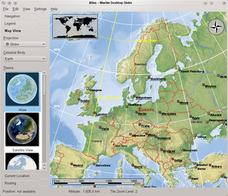
Marble is a virtual globe application which allows the user to choose among the Earth, the Moon, Venus, Mars and other planets to display as a 3-D model. It is free software under the terms of the GNU LGPL, developed by KDE for use on personal computers and smart phones. It is written in C++ and uses Qt.
The Master Genealogist (TMG) was genealogy software for Microsoft Windows first released in 1993 by Bob Velke. Data entry was customized through the use of user-defined events, names, and relationship types. Official support for TMG ceased at the end of 2014.
GenoPro is a software application for drawing family trees and genograms. GenoPro can store additional information such as pictures, contacts, places, sources, occupation and education history for each individual, as well as document the relationships among individuals.

Brian McClendon is an American software executive, engineer, and inventor. He was a co-founder and angel investor in Keyhole, Inc., a geospatial data visualization company that was purchased by Google in 2004 to produce Google Earth. Keyhole itself was spun off from another company called Intrinsic Graphics, of which McClendon was also a co-founder. He was inducted into the National Academy of Engineering in 2015.
RootsMagic is a genealogy software program designed and written by RootsMagic, Inc, a United States software design and development company founded by Bruce Buzbee in 1987. Bruce originally wrote the program Family Origins.
Google Fusion Tables was a web service provided by Google for data management. Fusion tables can be used for gathering, visualising and sharing data tables. Data are stored in multiple tables that Internet users can view and download.