Farafangana

Last updated
Farafangana
City
Madagascar74.136.jpg
View to a landscape near the city.
Farafangana map 1.JPG
Location of Farafangana in Madagascar
Country Madagascar
Region Atsimo-Atsinanana
District Farafangana (district)
Area
  Total27.0 km2 (10.4 sq mi)
Elevation
15 m (49 ft)
Population
 (2018 census)
  Total34,676
  Density1,300/km2 (3,300/sq mi)
Time zone UTC+3 (EAT)
postal code
309
Climate Af
Website www.farafangana.com

Farafangana is a city (commune urbaine) on the south-east coast of Madagascar and capital of the Atsimo-Atsinanana region.

Contents

Location

Farafangana is the capital of the region Atsimo-Atsinanana located approximately 400 kilometres south of the capital Antananarivo. It is at the southern end of the Canal des Pangalanes, [1] with the mouth of the Manampatrana River located on the north side of the town. It is 106km south of Manakara, about 2.5 hours travel time away. [2]

Settlements located to the north include Lokandambo, Manambotra, Ambahikarabo and Amboahangimamy, with Ambalolo to the west. To the south are Antananabo, Manambotra Atsimo and Marosondry. [3]

Economy

There is an airport in Farafangana (Farafangana Airport). One of the main crops in the region is pepper. [4]

Population

Natives are mainly from ethnic groups Antefasy, Rabakara, Antesaka and Zafisoro.

Education

Farafangana has a university. [5]

Tourism

The Manombo Reserve is located at 25 km to Farafangana. [6]

Roads

Rivers

The Manambava and the Manampatrana River that has its mouth into the Indian Ocean at Farafangana.

Sports

Climate

Climate data for Farafangana (1991–2020)
MonthJanFebMarAprMayJunJulAugSepOctNovDecYear
Record high °C (°F)34.5
(94.1)
34.4
(93.9)
34.8
(94.6)
34.5
(94.1)
33.7
(92.7)
31.5
(88.7)
30.7
(87.3)
29.9
(85.8)
30.8
(87.4)
32.1
(89.8)
33.3
(91.9)
34.1
(93.4)
34.8
(94.6)
Mean daily maximum °C (°F)29.5
(85.1)
29.7
(85.5)
29.4
(84.9)
28.5
(83.3)
27.1
(80.8)
25.1
(77.2)
24.2
(75.6)
24.3
(75.7)
25.4
(77.7)
26.8
(80.2)
28.2
(82.8)
29.4
(84.9)
27.3
(81.1)
Daily mean °C (°F)26.6
(79.9)
26.7
(80.1)
26.3
(79.3)
25.2
(77.4)
23.4
(74.1)
21.4
(70.5)
20.6
(69.1)
20.9
(69.6)
22.1
(71.8)
23.7
(74.7)
25.1
(77.2)
26.3
(79.3)
24.0
(75.2)
Mean daily minimum °C (°F)23.7
(74.7)
23.7
(74.7)
23.2
(73.8)
21.9
(71.4)
19.7
(67.5)
17.7
(63.9)
16.9
(62.4)
17.4
(63.3)
18.7
(65.7)
20.5
(68.9)
22.0
(71.6)
23.1
(73.6)
20.7
(69.3)
Record low °C (°F)17.1
(62.8)
17.8
(64.0)
17.0
(62.6)
13.5
(56.3)
12.1
(53.8)
11.2
(52.2)
11.2
(52.2)
11.5
(52.7)
12.3
(54.1)
14.2
(57.6)
14.9
(58.8)
17.0
(62.6)
11.2
(52.2)
Average precipitation mm (inches)269.5
(10.61)
254.8
(10.03)
294.3
(11.59)
229.6
(9.04)
208.7
(8.22)
138.6
(5.46)
148.8
(5.86)
73.3
(2.89)
69.6
(2.74)
82.5
(3.25)
87.2
(3.43)
159.3
(6.27)
2,016.2
(79.38)
Average precipitation days (≥ 1.0 mm)17.616.717.715.214.012.913.210.08.38.19.212.5155.4
Source: NOAA [7]

See also

Related Research Articles

<span class="mw-page-title-main">Fianarantsoa Province</span> Province in Madagascar

Fianarantsoa Province is a former province of Madagascar. It has an area of 103,272 km2 and population of 3,366,291. Its capital was Fianarantsoa. The province along with the 5 other was abolished in 2007 in favour of creation of smaller regions to facilitate administration.

<span class="mw-page-title-main">Manakara</span> Place in Fitovinany, Madagascar

Manakara is a city in Madagascar.

<span class="mw-page-title-main">Vangaindrano</span> Place in Atsimo-Atsinanana, Madagascar

Vangaindrano is a town and a district in Atsimo-Atsinanana Region, Madagascar with a population of 38,537 (2018).

<span class="mw-page-title-main">Atsimo-Atsinanana</span> Region in Madagascar

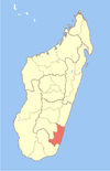
Atsimo-Atsinanana is a region in Madagascar. Its capital is Farafangana. The region used to be part of the Fianarantsoa Province.

<span class="mw-page-title-main">Fitovinany</span> Region in Madagascar

Fitovinany is a region located in southeast Madagascar. Its capital is Manakara. It is inhabited by the Antemoro people.

<span class="mw-page-title-main">Ihorombe</span> Region in Madagascar

Ihorombe is a region in Madagascar. It borders Haute Matsiatra region in north, Atsimo-Atsinanana in east, Anosy in south and Atsimo-Andrefana in west. The capital is Ihosy and the population was 418,520 in 2018. The area of Ihorombe is 26,391 km2 (10,190 sq mi) and it has one of the lowest population densities of the Malagasy regions.

Anosivelo is a rural municipality in Madagascar. It belongs to the district of Farafangana, which is a part of Atsimo-Atsinanana Region. The population of the commune was estimated to be approximately 17,000 in 2001 commune census.

<span class="mw-page-title-main">Anosy Tsararafa</span> Place in Atsimo-Atsinanana, Madagascar

Anosy Tsararafa is a rural municipality in Madagascar. It belongs to the district of Farafangana, which is a part of Atsimo-Atsinanana Region. The population of the commune was estimated to be approximately 20,000 in 2001 commune census.

Mahavelo is a town and commune in Madagascar. It belongs to the district of Farafangana, which is a part of Atsimo-Atsinanana Region. The population of the commune was estimated to be approximately 8,000 in 2001 commune census.

Manambotra Sud is a town and commune in Madagascar. It belongs to the district of Farafangana, which is a part of Atsimo-Atsinanana Region. The population of the commune was estimated to be approximately 5,000 in 2001 commune census.

Vohimasy is a town and commune in Madagascar. It belongs to the district of Farafangana, which is a part of Atsimo-Atsinanana Region. The population of the commune was estimated to be approximately 5,000 in 2001 commune census.

Bekaraoka is a rural municipality in Madagascar. It belongs to the district of Vangaindrano, which is a part of Atsimo-Atsinanana Region. The population of the commune was estimated to be approximately 3,000 in 2001 commune census.

Manombo is a village of the commune of Nosifeno in the district of Midongy-Atsimo in the region of Atsimo-Atsinanana in south-eastern Madagascar.

<span class="mw-page-title-main">Mahanoro</span> Place in Atsinanana, Madagascar

Mahanoro is a rural municipality located in the Atsinanana region of eastern Madagascar, along the coast.

<span class="mw-page-title-main">Manampatrana River</span> River in Madagascar

Manampatrana is a river in the region of Atsimo-Atsinanana in south-eastern Madagascar. It has its springs in the Andringitra Massif and flows into the Indian Ocean north of Farafangana.

Nosifeno is a town and commune in Madagascar. It belongs to the district of Midongy-Atsimo, which is a part of Atsimo-Atsinanana Region. There are 3881 inscribed voters in this commune. It is located at the Itomampy river. From the coast and Vangaindrano it can be reached by the unpaved, secondary road T18 of 94 km in very bad state of conservation.

The Farafangana mine is a large mine located in the southern part of Madagascar in Atsimo-Atsinanana. Farafangana represents one of the largest bauxite reserves in Madagascar and one of the largest in Africa, having estimated reserves of 100 million tonnes grading 37% aluminium oxide.

<span class="mw-page-title-main">Farafangana (district)</span> City & district in Atsimo-Atsinanana, Madagascar

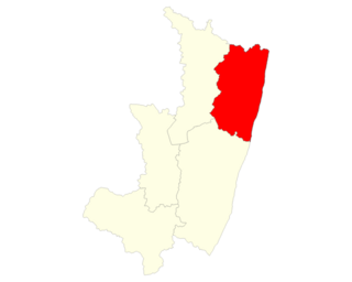
Farafangana is a district of Atsimo-Atsinanana in Madagascar. The district has an area of 2,824 km2 (1,090 sq mi), and the estimated population in 2020 was 436,226.

<span class="mw-page-title-main">Vangaindrano (district)</span> Place in Atsimo-Atsinanana, Madagascar

Vangaindrano is a district of Atsimo-Atsinanana in Madagascar. The area is 4,817 km2 (1,860 sq mi) and the population was estimated to be 376,110 in 2020.

Route nationale 12 is a primary highway in Madagascar of 240 kilometers (150 mi), running from Irondro to Vangaindrano. It crosses the regions of Vatovavy, Fitovinany and Atsimo-Atsinanana. It is paved but partly in bad condition.

References

  1. Madagascar & Comoros, p. 232 (Lonely Planet, 2008)
  2. Madagascar 2014-2015 Petit Futé, p. 249 (2013)
  3. "Redirect to /World/MA/02/Farafangana.HTML".
  4. (in French) www.commerce.gov.mg Archived 2013-03-24 at the Wayback Machine
  5. centre universitaire à Farafangana
  6. "travalmadagascar.org". Archived from the original on 2020-03-27. Retrieved 2013-03-25.
  7. "Farafangana Climate Normals 1991–2020". World Meteorological Organization Climatological Standard Normals (1991–2020). National Oceanic and Atmospheric Administration. Archived from the original on 25 September 2023. Retrieved 25 September 2023.

22°49′S47°49′E / 22.817°S 47.817°E / -22.817; 47.817