Fatahillah Square

Last updated
Fatahillah Square, the restored 18th-century water pump, and the Jakarta History Museum. Jakarta History Museum March 2015.JPG
Fatahillah Square, the restored 18th-century water pump, and the Jakarta History Museum.

Fatahillah Square (Indonesian: Taman Fatahillah) is the historical center of the old Batavia. The square is located at the center of Jakarta Old Town. Today the square is a tourist area home to the Jakarta History Museum, Wayang Museum and Fine Art and Ceramics Museum in Kota, Jakarta.

Contents

History

Pre-1632 layout

From the beginning of its foundation, Batavia was a well-planned Dutch forted city. [1] The square that would become Fatahillah Square was first recorded in c.1627 as Nieuwe Markt (Dutch "New Marketplace"). At that time the mouth of the river Ciliwung (named then as Groote Rivier, "Big River") meandered toward the west-side of the square, giving the square a riverfront quality. The square was only half the size of the present square, the eastern half of the present square was occupied by shophouses. Shophouses also flanked the square at the north side, while the first City Hall of Batavia was built to the south of the square, center to the north-south axis of the Prinsenstraat (now Jalan Cengkeh), proof of urban planning in the forted city. [2] The name Stadhuisplein was probably given immediately to the square following the completion of the city hall.

Post-1632 layout

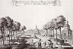
Drawing of the former city hall (Dutch: stadhuis
) and New Church of Holland (Nieuwe Hollandse Kerk) in Batavia, Dutch East Indies by Danish painter Johannes Rach, late 18th century Batavia - Townhall 1770.jpg
Drawing of the former city hall (Dutch : stadhuis) and New Church of Holland (Nieuwe Hollandse Kerk) in Batavia, Dutch East Indies by Danish painter Johannes Rach, late 18th century

In 1632, Batavia underwent a major restructuration. To strengthen the defense system, governor-general Jacques Specx (1629-1632) redesigned Batavia with an outer city wall, defended by a system of outer and inner moat. The inner city was planned following a grid-like planning and crisscrossed with a network of canals. [3] To accommodate the grid-like layout, the Groote Rivier was normalized into a straight north-to-south waterway. The shop houses at the eastern side of the square were also demolished. With the normalization of the Groote Rivier and the demolition of the east shop houses, the square became completely enclosed with buildings. The Prinsestraat (present Jalan Cengkeh), which in the beginning formed the street that leads to the Castle, were established as an urban center, connecting the Castle south gate with the City Hall, forming an impressive vista on the seat of government. [1] Beginning from the year up until around late 18th-century, the Stadhuisplein was flanked with the City Hall to the south, a church to the west, some shop houses to the north, and the Tijgersgracht to the east. [4]

In 1635, a Chinese clothing bazaar occupied the northwest part of the square. This bazaar was demolished in the early 18th century. [2] The location of the clothing bazaar corresponds more or less with the area in front of present Cafe Batavia.

Modern period

The merging of the Stadhuisplein with the front courtyard of the Palais van Justitie (now the Ceramic Museum in the 19th-century. COLLECTIE TROPENMUSEUM Het gebouw van de Raad van Justitie aan het Stadhuisplein Batavia TMnr 60016063.jpg
The merging of the Stadhuisplein with the front courtyard of the Palais van Justitie (now the Ceramic Museum in the 19th-century.

In late 19th century, the Stadhuisplein was traversed with a tramline, passing diagonally from Binnen Nieuwpoortstraat at the south (now Jalan Pintu Besar Utara), to Prinsenstraat (now Jalan Cengkeh) at the north. [5] C. 1870, with the elimination of the Tijgersgracht and the completion of the Palais van Justitie (now Fine Arts and Ceramics Museum), the total area of the Stadhuisplein expanded slightly to the east. [6] This layout of the square will be the final layout of the square.

At the beginning of the 20th century, the northeast shop houses were demolished to make way for the Post- en telegraaf kantoor aan het Stadhuisplein (now Kota Post Office). Demolition of these shophouses incited controversy among the architects and academics. Both Berlage and Karsten, noted Dutch architects, cited the addition of the building as destroying the traditional city structure of the Old Town. [7]

Post-colonial period

Buses and taxis at Taman Fatahillah. COLLECTIE TROPENMUSEUM Bussen en taxi's op Taman Fatahillah TMnr 20018032.jpg
Buses and taxis at Taman Fatahillah.

The name Stadhuisplein lingered until nationalization of street names in Indonesia when the name was changed into Taman Fatahillah ("Fatahillah Square") after Fatahillah, a pre-Dutch 16th-century commander of the Sultanate of Demak who recaptured the port city from the Portuguese. [2]

In the year 1970, restoration of the square and a couple of landmark in the Old Town was done by the governor Ali Sadikin. The former city hall was made a history museum in 1974. Also in that year, the 18th-century artesian water pump was restored in the middle of the square. [8]

Present

Ondel-ondel performance at Fatahillah Square Ondel-Ondel Fatahillah Square.JPG
Ondel-ondel performance at Fatahillah Square

Together with the Kota Tua Jakarta, Fatahillah Square is a car-free area.

Related Research Articles

<span class="mw-page-title-main">Batavia, Dutch East Indies</span> Capital of the Dutch East Indies

Batavia was the capital of the Dutch East Indies. The area corresponds to present-day Jakarta, Indonesia. Batavia can refer to the city proper or its suburbs and hinterland, the Ommelanden, which included the much larger area of the Residency of Batavia in the present-day Indonesian provinces of Jakarta, Banten and West Java.

<span class="mw-page-title-main">Jakarta Kota railway station</span> Railway station in Indonesia

Jakarta Kota Station is a railway station, located in the old city core of Kota, Jakarta, Indonesia.

<span class="mw-page-title-main">Great Post Road</span> Historical road in Java, Indonesia constructed in the early 19th century

The Great Post Road is the name for the historical road that runs across Java that connects Anyer and Panarukan. It was built during the reign of Herman Willem Daendels (1808–1811), governor-general of the Dutch East Indies, using unpaid forced labor that cost thousands of lives.

<span class="mw-page-title-main">Pasar Minggu</span> District in Jakarta, Indonesia

Pasar Minggu is a district in the administrative city of South Jakarta, Indonesia. The area is known for its traditional Sunday market, famous for the fruit market. Historically, Pasar Minggu is a fruit cultivation area developed by the Dutch government during the colonial period. The central point of the cultivation area is the traditional market of Pasar Minggu, located in what is now the lower-division Pasar Minggu subdistrict. Teak forest could also be found in the Pasar Minggu district, notably around the Jati Padang subdistrict. Most of these areas have been converted into residential areas as Jakarta grows southward.

<span class="mw-page-title-main">Senen</span> Subdistrict in Central Jakarta Administrative City, Indonesia

Senen is a long-established urban district of Central Jakarta, Indonesia that has kept many tourist attractions such as two museums, the National Library of Indonesia, Gelanggang Remaja Senen, and narrow alleys with old Chinese and similar style shops and restaurants. It was first developed in the 18th century as Pasar Senen when Governor Daendels established the bovenstad as the new center of government of the fledgling city. Its core remains in what is now the lower-division subdistrict of Senen, Kwitang, Kenari, Paseban, Kramat, and Bungur. Senen is bounded by a railway line to the east, Ciliwung River to the west, Pramuka Street to the south, and Abdul Rahman Saleh-Kwini II-Senen Raya IV Street to the north. The name is derived from Pasar Senen,.

<span class="mw-page-title-main">Taman Sari, Jakarta</span> District in West Jakarta, Indonesia

Taman Sari is a district of West Jakarta, Indonesia. It is the smallest subdistrict of West Jakarta (4.37 km2). It is bounded by Central Jakarta to the south and to the east, and by Pademangan in North Jakarta to the north.

<span class="mw-page-title-main">Kebayoran Baru</span> District in South Jakarta, Indonesia

Kebayoran Baru is a district in the administrative city of South Jakarta, Indonesia. The name was derived from a planned satellite city of the same name which was developed in the post-war period. Kebayoran Baru was the last residential area to be developed by the Dutch colonial administration. The urban planning was laid in a concept of the Garden city movement, consisting of a well-planned residential area, a shopping center, and a business district, supported with civic facilities such as schools, places of worship, hospitals, and parks. Today, the district is home to many important government institutions, such as the Indonesia Stock Exchange building, the ASEAN Headquarters building, the National Police headquarters, and the City Hall of South Jakarta. Sudirman Central Business District is also located in the district.

<span class="mw-page-title-main">Cilincing</span> Neighborhood in Jakarta, Indonesia

Cilincing is a historic neighborhood of the coast of Jakarta, Indonesia. It is sandwiched between the Port of Tanjung Priok to the west and River Titram to the east. Cilincing has been for some decades one of the districts of North Jakarta which in turn encompasses as far as Marunda and some non-coastal hinterland.

<span class="mw-page-title-main">Kota Tua Jakarta</span> Historic downtown of northwest Jakarta, Indonesia

Kota Tua Jakarta, officially known as Kota Tua, is a neighborhood comprising the original downtown area of Jakarta, Indonesia. It is also known as Oud Batavia, Benedenstad, or Kota Lama.

<span class="mw-page-title-main">Royal Batavian Society of Arts and Sciences</span>

The Royal Batavian Society of Arts and Sciences was a Dutch learned society in Batavia.

<span class="mw-page-title-main">History of Jakarta</span> Timeline of Jakartas history

Jakarta is Indonesia's capital and largest city. Located on an estuary of the Ciliwung River, on the northwestern part of Java, the area has long sustained human settlement. Historical evidence from Jakarta dates back to the 4th century CE, when it was a Hindu settlement and port. The city has been sequentially claimed by the Indianized kingdom of Tarumanegara, the Hindu Kingdom of Sunda, the Muslim Sultanate of Banten, and by Dutch, Japanese and Indonesian administrations. The Dutch East Indies built up the area before it was taken during World War II by the Empire of Japan and finally became independent as part of Indonesia.

<span class="mw-page-title-main">Jakarta History Museum</span> History museum in Jakarta, Indonesia

The Jakarta History Museum, also known as Fatahillah Museum or Batavia Museum, is located in the Old Town of Jakarta, Indonesia. The building was built in 1710 as the Stadhuis of Batavia. Jakarta History Museum opened in 1974 and displays objects from the prehistory period of the city region, the founding of Jayakarta in 1527, and the Dutch colonization period from the 16th century until Indonesia's Independence in 1945.

<span class="mw-page-title-main">Ancol</span> Administrative village in Special Capital City District of Jakarta, Indonesia

Ancol is a coastal lowland area located to the east of Kota Tua Jakarta in northern Jakarta, in Indonesia. The coastal lowland stretched from Kota Tua Jakarta to the west and Tanjung Priok to the east. Today, Ancol contains the main beach resort of Jakarta. Taman Impian Jaya Ancol, the largest integrated tourism area in Southeast Asia, is located in Ancol.

<span class="mw-page-title-main">Jengki style</span> Indonesian architectural style of the mid-20th century

Jengki, also known as Yankee style, was a post-war modernist architectural style developed in Indonesia following its independence. The style was popular between late 1950s and early 1960s.

<span class="mw-page-title-main">Colonial architecture in Jakarta</span>

Colonial buildings and structures in Jakarta include those that were constructed during the Dutch colonial period of Indonesia. The period succeeded the earlier period when Jakarta, governed by the Sultanate of Banten, were completely eradicated and replaced with a walled city of Batavia. The dominant styles of the colonial period can be divided into three periods: the Dutch Golden Age, the transitional style period, and Dutch modernism. Dutch colonial architecture in Jakarta is apparent in buildings such as houses or villas, churches, civic buildings, and offices, mostly concentrated in the administrative city of Central Jakarta and West Jakarta.

Kwitang is an administrative village (kelurahan) in the subdistrict (kecamatan) of Senen, Central Jakarta. It is one of the historic administrative village of Jakarta. The boundary of Kwitang is the Ciliwung to the west, Jalan Kramat Kwitang to the north, Jalan Kramat Raya to the east, and Jalan Kramat 4 to the south.

<span class="mw-page-title-main">Batavia Castle</span> VOC fort in Jakarta

Batavia Castle was a fort located at the mouth of Ciliwung River in Jakarta. Batavia Castle was the administrative center of Dutch East India Company (VOC) in Asia.

<span class="mw-page-title-main">Pancasila Building</span> Historic building in Jakarta, Indonesia

The Pancasila Building is a historic building located in Central Jakarta, Indonesia. The name "Pancasila" refers to the speech delivered by Sukarno in the building on which he spoke about the concept of Pancasila, a philosophical concept which would be the foundation of the Indonesian nation, on June 1, 1945. Built in the early 1830s, the building is one of the many 19th-century colonial landmarks in Jakarta. The Pancasila Building currently belongs to and is under the preservation of the Indonesian Ministry of Foreign Affairs.

<span class="mw-page-title-main">Ministry of Transportation Building, Jakarta</span> Government building

The Indonesian Ministry of Transportation Building is a historic building and a cultural property located in Jakarta, Indonesia. The building is currently the headquarter of the Indonesian Ministry of Transportation. The building, established as the headquarter of the Koninklijke Paketvaart-Maatschappij (KPM), was the first project of AIA Bureau, the biggest architecture consultant in the Dutch East Indies.

References

  1. 1 2 de Haan 1922, p. 46-7.
  2. 1 2 3 Bollee, Kaart van Batavia 1667.
  3. Cribb & Kahin 2004, p. 463.
  4. Petrus Conradi, Plan der stad en 't Kasteel Batavia 1770.
  5. Weperen, Stads-kaart van Batavia 1931.
  6. Top. Bureau, Kaart van Batavia en Omstreken 1897.
  7. Indische Literaire Wandelingen - Jakarta.
  8. de Vletter, Voskuil & van Diessen 1997, pp. 122.

Works cited

6°08′05″S106°48′48″E / 6.1347°S 106.8133°E / -6.1347; 106.8133