
Raleigh is the capital city of the U.S. state of North Carolina and the seat of Wake County. It is the second-most populous city in North Carolina, after Charlotte. Raleigh is the tenth-most populous city in the Southeast, the 41st-most populous city in the U.S., and the largest city of the Research Triangle metro area. Raleigh is known as the "City of Oaks" for its many oak trees, which line the streets in the heart of the city. The city covers a land area of 147.6 sq mi (382 km2). The U.S. Census Bureau counted the city's population as 467,665 in the 2020 census. It is one of the fastest-growing cities in the United States. The city of Raleigh is named after Sir Walter Raleigh, who established the now-lost Roanoke Colony in present-day Dare County.
The Research Triangle, or simply The Triangle, are both common nicknames for a metropolitan area in the Piedmont region of the U.S. state of North Carolina. Anchored by the cities of Raleigh and Durham and the town of Chapel Hill, the region is home to three major research universities: North Carolina State University, Duke University, and the University of North Carolina at Chapel Hill, respectively. The "Triangle" name originated in the 1950s with the creation of Research Triangle Park located between the three anchor cities, which is the largest research park in the United States and home to numerous high tech companies.

Hollywood Boulevard is a major east–west street in Los Angeles, California. It runs through the Hollywood, East Hollywood, Little Armenia, Thai Town, and Los Feliz districts. Its western terminus is at Sunset Plaza Drive in the Hollywood Hills and its eastern terminus is at Sunset Boulevard in Los Feliz. Hollywood Boulevard is famous for running through the tourist areas in central Hollywood, including attractions such as the Hollywood Walk of Fame and the Ovation Hollywood shopping and entertainment complex.

U.S. Route 401 (US 401) is a north–south United States highway, a spur of U.S. Route 1, that travels along the Fall Line from Sumter, South Carolina to Interstate 85 near Wise, North Carolina.
Fourth Street Live! is a 350,000-square-foot (33,000 m2) entertainment and retail complex located on 4th Street, between Liberty and Muhammad Ali Boulevard, in Downtown Louisville, Kentucky. It is owned and was developed by the Cordish Company; it was designed by Louisville architects, Bravura Corporation. Fourth Street Live! first opened to the public on June 1, 2004, and all stores were completed for the grand opening on October 30, 2004. City planners hoped that the district would attract further commercial business development while providing an attractive entertainment venue for the city's hotel and tourist business as well as the local population.
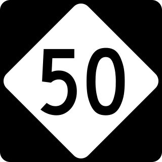
North Carolina Highway 50 (NC 50) is a primary state highway in the U.S. state of North Carolina. It goes from Topsail Beach in the south to Creedmoor in the north, connecting the cities of Warsaw, Newton Grove, Benson, and Raleigh.

Martin Marietta Center for the Performing Arts is the premier location for cultural arts and entertainment in Raleigh, North Carolina. The center consists of four unique venues, Raleigh Memorial Auditorium, Meymandi Concert Hall, A.J. Fletcher Opera Theater, and Kennedy Theatre.
Cooper Carry is a U.S.-based design firm providing architecture, planning, landscape architecture, interior design and environmental graphic design. The company is based in Atlanta with offices in Alexandria, Virginia; New York City; and.

The Central Business District is one of seven development districts in Saskatoon, Saskatchewan, Canada. The central business district is Ward 6 of a Mayor-Council government represented by councillor Cynthia Block. Formerly called West Saskatoon, this area arose when the steam engines built their pumping stations on the lower west bank of the South Saskatchewan River. Retail enterprises sprang up around the newly created train station and rail yards. The city of Saskatoon's Central Business District has shopping malls and boutiques.

Hillsborough Street is a business and cultural thoroughfare through Raleigh, North Carolina, United States. The street serves as a center for social life among North Carolina State University and Meredith College students.
Downtown Sacramento is the central business district of the city of Sacramento. Downtown is generally defined as the area south of the American River, east of the Sacramento River, north of Broadway, and west of 16th Street. The central business district is generally defined as north of R Street, south of H Street, east of the Sacramento River, and west of 16th Street. Downtown Sacramento is currently undergoing a major revitalization project.

Downtown is the central economic, political, and cultural district of the city of Providence, Rhode Island, United States. It is bounded on the east by Canal Street and the Providence River, to the north by Smith Street, to the west by Interstate 95, and to the south by Henderson Street. The highway serves as a physical barrier between the city's commercial core and neighborhoods of Federal Hill, West End, and Upper South Providence. Most of the downtown is listed on the National Register of Historic Places as the Downtown Providence Historic District.

Downtown Evansville is the central business district of Evansville, Indiana. The boundaries of downtown Evansville have changed as the city has grown, but they are generally considered to be between Canal Street at the south and east, the Lloyd Expressway to the north, Pigeon Creek to the northwest, and the Ohio River to the southeast south and southwest. Downtown Evansville is entirely within Pigeon Township.
Downtown Beaumont is the central business district of Beaumont, Texas. It is where the city's highrise buildings are located, as well as being the center of government and business for the region. Downtown Beaumont is currently experiencing a renaissance, with streets, sidewalks and historic buildings receiving significant attention.
The culture of Columbus, Ohio, is particularly known for museums, performing arts, sporting events, seasonal fairs and festivals, and architecture of various styles from Greek Revival to modern architecture.
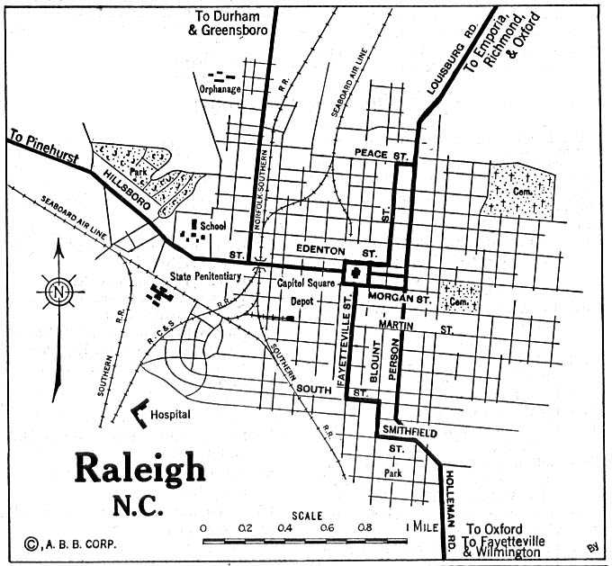
The following is a timeline of the history of the city of Raleigh, North Carolina, USA.

Argyle Street is located in downtown Halifax, Nova Scotia, Canada. It is approximately 460 metres long and stretches four city blocks to the west of, and parallel to, Barrington Street from Duke Street to Blowers Street. The street is a popular centre for live music, nightlife, theatre, and al fresco dining.
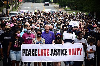
This is a list of George Floyd protests in North Carolina, United States.

East Hargett Street is a street in downtown Raleigh, North Carolina. It was plotted in 1792 as one of the original streets in the city, and in the early 1900s hosted a concentration of black-owned businesses, thus earning the monikers "Black Main Street"/"Negro Main Street". The street experienced an economic decline in the 1960s.


