Related Research Articles
In object-oriented programming, a class defines the shared aspects of objects created from the class. The capabilities of a class differ between programming languages, but generally the shared aspects consist of state (variables) and behavior (methods) that are each either associated with a particular object or with all objects of that class.
Cocoa is Apple's native object-oriented application programming interface (API) for its desktop operating system macOS.
In software engineering and computer science, abstraction is the process of generalizing concrete details, such as attributes, away from the study of objects and systems to focus attention on details of greater importance. Abstraction is a fundamental concept in computer science and software engineering, especially within the object-oriented programming paradigm. Examples of this include:
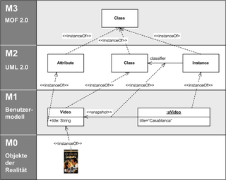
The Meta-Object Facility (MOF) is an Object Management Group (OMG) standard for model-driven engineering. Its purpose is to provide a type system for entities in the CORBA architecture and a set of interfaces through which those types can be created and manipulated. MOF may be used for domain-driven software design and object-oriented modelling.

A scene graph is a general data structure commonly used by vector-based graphics editing applications and modern computer games, which arranges the logical and often spatial representation of a graphical scene. It is a collection of nodes in a graph or tree structure. A tree node may have many children but only a single parent, with the effect of a parent applied to all its child nodes; an operation performed on a group automatically propagates its effect to all of its members. In many programs, associating a geometrical transformation matrix at each group level and concatenating such matrices together is an efficient and natural way to process such operations. A common feature, for instance, is the ability to group related shapes and objects into a compound object that can then be manipulated as easily as a single object.
A dynamic programming language is a type of programming language that allows various operations to be determined and executed at runtime. This is different from the compilation phase. Key decisions about variables, method calls, or data types are made when the program is running, unlike in static languages, where the structure and types are fixed during compilation. Dynamic languages provide flexibility. This allows developers to write more adaptable and concise code.
ABAP is a high-level programming language created by the German software company SAP SE. It is currently positioned, alongside Java, as the language for programming the SAP NetWeaver Application Server, which is part of the SAP NetWeaver platform for building business applications.
A GIS file format is a standard for encoding geographical information into a computer file, as a specialized type of file format for use in geographic information systems (GIS) and other geospatial applications. Since the 1970s, dozens of formats have been created based on various data models for various purposes. They have been created by government mapping agencies, GIS software vendors, standards bodies such as the Open Geospatial Consortium, informal user communities, and even individual developers.
In computer science, message passing is a technique for invoking behavior on a computer. The invoking program sends a message to a process and relies on that process and its supporting infrastructure to then select and run some appropriate code. Message passing differs from conventional programming where a process, subroutine, or function is directly invoked by name. Message passing is key to some models of concurrency and object-oriented programming.
When classification is performed by a computer, statistical methods are normally used to develop the algorithm.
In object-oriented programming, inheritance is the mechanism of basing an object or class upon another object or class, retaining similar implementation. Also defined as deriving new classes from existing ones such as super class or base class and then forming them into a hierarchy of classes. In most class-based object-oriented languages like C++, an object created through inheritance, a "child object", acquires all the properties and behaviors of the "parent object", with the exception of: constructors, destructors, overloaded operators and friend functions of the base class. Inheritance allows programmers to create classes that are built upon existing classes, to specify a new implementation while maintaining the same behaviors, to reuse code and to independently extend original software via public classes and interfaces. The relationships of objects or classes through inheritance give rise to a directed acyclic graph.
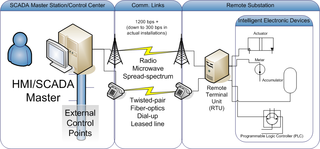
Distributed Network Protocol 3 (DNP3) is a set of communications protocols used between components in process automation systems. Its main use is in utilities such as electric and water companies. Usage in other industries is not common. It was developed for communications between various types of data acquisition and control equipment. It plays a crucial role in SCADA systems, where it is used by SCADA Master Stations, Remote Terminal Units (RTUs), and Intelligent Electronic Devices (IEDs). It is primarily used for communications between a master station and RTUs or IEDs. ICCP, the Inter-Control Center Communications Protocol, is used for inter-master station communications. Competing standards include the older Modbus protocol and the newer IEC 61850 protocol.

An asteroid spectral type is assigned to asteroids based on their reflectance spectrum, color, and sometimes albedo. These types are thought to correspond to an asteroid's surface composition. For small bodies that are not internally differentiated, the surface and internal compositions are presumably similar, while large bodies such as Ceres and Vesta are known to have internal structure. Over the years, there has been a number of surveys that resulted in a set of different taxonomic systems such as the Tholen, SMASS and Bus–DeMeo classifications.

A thematic map is a type of map that portrays the geographic pattern of a particular subject matter (theme) in a geographic area. This usually involves the use of map symbols to visualize selected properties of geographic features that are not naturally visible, such as temperature, language, or population. In this, they contrast with general reference maps, which focus on the location of a diverse set of physical features, such as rivers, roads, and buildings. Alternative names have been suggested for this class, such as special-subject or special-purpose maps, statistical maps, or distribution maps, but these have generally fallen out of common usage. Thematic mapping is closely allied with the field of Geovisualization.
An object-based spatial database is a spatial database that stores the location as objects. The object-based spatial model treats the world as surface littered with recognizable objects, which exist independent of their locations.
In geography and particularly in geographic information science, a geographic feature or simply feature is a representation of phenomenon that exists at a location in the space and scale of relevance to geography; that is, at or near the surface of Earth. It is an item of geographic information, and may be represented in maps, geographic information systems, remote sensing imagery, statistics, and other forms of geographic discourse. Such representations of phenomena consist of descriptions of their inherent nature, their spatial form and location, and their characteristics or properties.
A geographic data model, geospatial data model, or simply data model in the context of geographic information systems, is a mathematical and digital structure for representing phenomena over the Earth. Generally, such data models represent various aspects of these phenomena by means of geographic data, including spatial locations, attributes, change over time, and identity. For example, the vector data model represents geography as collections of points, lines, and polygons, and the raster data model represent geography as cell matrices that store numeric values. Data models are implemented throughout the GIS ecosystem, including the software tools for data management and spatial analysis, data stored in a variety of GIS file formats, specifications and standards, and specific designs for GIS installations.
Cartographic generalization, or map generalization, includes all changes in a map that are made when one derives a smaller-scale map from a larger-scale map or map data. It is a core part of cartographic design. Whether done manually by a cartographer or by a computer or set of algorithms, generalization seeks to abstract spatial information at a high level of detail to information that can be rendered on a map at a lower level of detail.

Object-oriented programming (OOP) is a programming paradigm based on the concept of objects, which can contain data and code: data in the form of fields, and code in the form of procedures. In OOP, computer programs are designed by making them out of objects that interact with one another.
Objective-C is a high-level general-purpose, object-oriented programming language that adds Smalltalk-style message passing (messaging) to the C programming language. Originally developed by Brad Cox and Tom Love in the early 1980s, it was selected by NeXT for its NeXTSTEP operating system. Due to Apple macOS’s direct lineage from NeXTSTEP, Objective-C was the standard language used, supported, and promoted by Apple for developing macOS and iOS applications from 1997, when Apple purchased NeXT until the introduction of the Swift language in 2014.
References
- ↑ "GML Simple Features Profile". OGC. Retrieved 11 July 2011.
- ↑ "PT Realty". www.pro-teqsurfacing.com. Retrieved 2025-01-08.
| | This cartography or mapping term article is a stub. You can help Wikipedia by expanding it. |