
Sorong Regency is a regency of the Southwest Papua province of Indonesia. It covers an area of 13,075.28 km2, and had a population of 70,619 at the 2010 Census, and 118,679 at the 2020 Census; the official estimate as of mid-2023 was 129,963. Its administrative centre is the town of Aimas. Sorong Regency surrounds Sorong City (Kota) on the landward side; the city is administratively independent of the Regency and is not included in the above statistics; Sorong City has an airport, Sorong Airport, which also serves the Regency.

Deiyai Regency is one of the regencies (kabupaten) in the Indonesian province of Central Papua; it was formed on 29 October 2008 from the southeastern corner of the Paniai Regency area, and inaugurated by the Indonesian Minister of Home Affairs, Mardiyanto. The legal basis for the formation of this regency was the Law of the Republic of Indonesia of 2008 Number 55.
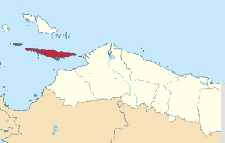
Yalimo Regency is one of the regencies in the Indonesian province of Highland Papua. It covers an area of 4,320.29 km3, and had a population at the 2010 Census of 50,763 which doubled to reach 101,973 at the 2020 Census; the official estimate as at mid 2023 was 106,740. The administrative centre is at Elelim. The indigenous inhabitants of this well-forested mountainous area are the Yali people.

Waropen Regency is one of the regencies (kabupaten) in Papua Province, Indonesia. The Regency covers an area of 10,843.97 km2, and it had a population of 24,639 at the 2010 Census and 33,943 at the 2020 Census; the official estimate as at mid 2022 was 36,974 - comprising 19,415 males and 17,559 females. The capital is the town of Botawa.
Tolikara Regency is one of the regencies (kabupaten) in the Indonesian province of Highland Papua. It covers an area of 14,564 km2, and had a population of 114,427 at the 2010 Census and 239,543 at the 2020 Census; the official estimate as at mid 2022 was 244,345. The administrative centre of Tolikara Regency is the town of Karubaga.
Supiori Regency is a regency in the Indonesian province of Papua. The Regency has an area of 634.24 km2 including the Aruri Islands group to the south, and had a population of 15,874 at the 2010 Census and 22,547 at the 2020 Census; the official estimate as at mid 2022 was 23,247 - comprising 12,056 males and 11,191 females. Until 8 January 2004, this area was part of the Biak Numfor Regency, from which it was split off in accordance with the Law dated 18 December 2003.

Puncak Jaya Regency is one of the regencies (kabupaten) in the Indonesian province of Central Papua. It is an inland highland regency, lying directly east of Paniai Regency and west of Jayawijaya Regency and Tolikara Regency. As of 2004, it was reported that these four regencies had a population that is 93–97% ethnic Papua; however this included areas which have subsequently been formed into new regencies.
Yapen Islands Regency is a regency (kabupaten) in Papua Province of eastern Indonesia. It covers an area of 2,432.49 km2 (939.19 sq mi), and had a population of 82,951 at the 2010 Census and 112,676 at the 2020 Census; the official estimate as at mid 2022 was 116,107. It comprises an archipelago which lies in Cenderawasih Bay off the north coast of Western New Guinea.

Pinrang Regency is one of the twenty-one regencies in South Sulawesi Province of Indonesia. Pinrang town in Watang Sawitto District is the administrative capital of Pinrang Regency. The regency is situated in the northwest of the South Sulawesi peninsula, and covers a land area of 1,896.57 km2. It had a population of 351,161 at the 2010 Census and 403,994 at the 2020 Census; the official estimate as at mid 2023 was 417,932.

Paser Regency is the southernmost regency (kabupaten) within the East Kalimantan province of Indonesia. It was created in 1959, originally spelt "Pasir Regency", but renamed "Paser" in 2007; however its northeastern districts were split off on 10 April 2002 to form the new Penajam North Paser Regency. The residual regency covers an area of 11,603.94 km2, and it had a population of 230,316 at the 2010 Census and 275,452 at the 2020 Census; the official estimate as at mid-2023 was 303,424. Its administrative centre is the town of Tana Paser.
Sukamara Regency is one of the thirteen regencies which comprise the Central Kalimantan Province on the island of Kalimantan (Borneo), Indonesia. It was created on 10 April 2002 from the former southwest part of West Kotawaringin Regency. The town of Sukamara is the capital of Sukamara Regency, which covers an area of 3,827 km2. The population of the Regency was 44,952 at the 2010 Census and 63,464 at the 2020 Census; the official estimate as at mid 2023 was 66,633.
Kolaka Regency is a regency of Southeast Sulawesi Province, Indonesia. It covers an area of 2,960.73 km2 (1,143.14 sq mi) and had a population of 208,817 at the 2010 Census, rising to 237,587 at the 2020 Census; the official estimate as at mid 2023 was 247,680. The principal town lies at Kolaka.

North Kolaka Regency is a regency in the northwest part of Southeast Sulawesi province of Indonesia. It was created on 18 December 2003 from the former northern districts of Kolaka Regency. It covers an area of 2,932 km2, and had a population of 121,476 at the 2010 Census, and 137,700 at the 2020 Census; the official estimate as at mid 2023 was 140,488 - comprising 71,995 males and 68,493 females. The principal town lies at Lasusua.

South Minahasa Regency is a regency in North Sulawesi, Indonesia. Its capital is the town of Amurang. It was originally part of the Minahasa Regency until it was established as a separate regency on 25 February 2003. In turn, nearly four years later, a new Southeast Minahasa Regency was established as a separate regency from part of the South Minahasa Regency on 2 January 2007. The residual Regency now covers an area of 1,456.74 km2, and had a population of 195,553 at the 2010 Census; this had risen to 236,463 at the 2020 Census; the official estimate as at mid 2023 was 244,590.

Southeast Minahasa Regency is a regency in North Sulawesi, Indonesia. It covers a land area of 730.63 km2, and had a population of 100,443 at the 2010 Census; this had risen to 116,323 at the 2020 Census, and the official estimate as at mid 2023 was 118,946. It was established as a separate regency from the south-eastern part of the South Minahasa Regency on 2 January 2007. Its administrative centre is at the town of Ratahan.

Manokwari Regency is a regency in West Papua, Indonesia. Following the splitting away of twenty of its former districts in 2013, it now covers an area of 2,762.89 km2 and had a population of 192,663 at the 2020 Census; the official estimate as at mid 2023 was 201,821. The administrative centre is presently at the town of Manokwari, which is also the capital of the province.

Maybrat Regency is a regency of Southwest Papua Province of Indonesia. It has an area of 5,461.69 km2 (2,108.77 sq mi), and had a population of 33,081 at the 2010 Census and 42,991 at the 2020 Census; the official estimate as at mid 2023 was 46,287. The administrative centre is the town of Kumurkek, in Aifat District. The Maybrat language is spoken in the regency.

Tambrauw Regency is a regency of Southwest Papua Province, Indonesia, in the Bird's Head Peninsula of Papua Island. It was created on 29 October 2008 from what had been an eastern part of Sorong Regency, originally as part of the province of West Papua. Much of the regency is located on the Tamrau Mountains that the local government declarated Tambrauw as a "conservation regency".
Kwoor is a District of Tambrauw Regency in Southwest Papua, Indonesia.
Wilhem Roumbouts is a District in Tambrauw Regency in Southwest Papua, Indonesia. Its district capital is Tabamsere.
