
Rajasthan is a state in northwestern India. It covers 342,239 square kilometres (132,139 sq mi) or 10.4 per cent of India's total geographical area. It is the largest Indian state by area and the seventh largest by population. It is on India's northwestern side, where it comprises most of the wide and inhospitable Thar Desert and shares a border with the Pakistani provinces of Punjab to the northwest and Sindh to the west, along the Sutlej-Indus River valley. It is bordered by five other Indian states: Punjab to the north; Haryana and Uttar Pradesh to the northeast; Madhya Pradesh to the southeast; and Gujarat to the southwest. Its geographical location is 23°.3' to 30°.12' North latitude and 69°.30' to 78°.17' East longitude, with the Tropic of Cancer passing through its southernmost tip.
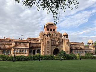
Bikaner is a city in the northwest of the state of Rajasthan, India. It is located 330 kilometres (205 mi) northwest of the state capital, Jaipur. Bikaner city is the administrative headquarters of Bikaner District and Bikaner division.

Jodhpur is the second-largest city of the north-western Indian state of Rajasthan after its capital Jaipur. As of 2023, the city has a population of 1.83 million. It serves as the administrative headquarters of the Jodhpur district and Jodhpur division. It is historic capital of the Kingdom of Marwar, founded in 1459 by Rao Jodha, a Rajput chief of the Rathore clan. On 11 August 1947 four days prior to the Indian independence, Maharaja Hanwant Singh, the last ruler of Jodhpur state signed the Instrument of Accession and merged his state in Union of India. On 30 March 1949, it became part of the newly formed state of Rajasthan, which was created after merging the states of the erstwhile Rajputana Agency.

Bhairon Singh Shekhawat was an Indian politician who served as the 11th vice president of India. He served in that position from August 2002, when he was elected to a five-year term by the electoral college following the death of Krishan Kant, until he resigned on 21 July 2007, after losing the presidential election to Pratibha Patil. Bhairon Singh Shekhawat was a member of the Bharatiya Janata Party. He served as the Chief Minister of Rajasthan three times, from 1977 to 1980, 1990 to 1992 and 1993 to 1998. He represented several constituencies in Rajasthan Vidhan Sabha from 1952 to 2002. He was also awarded Padma Bhushan in the year 2003.
Bharatpur is a city in the Indian state of Rajasthan, 180 km (110 mi) south of India's capital, New Delhi, 178 km (111 mi) from Rajasthan's capital Jaipur, 55 km (34 mi) west of Agra of Uttar Pradesh and 38 km (24 mi) from Mathura of Uttar Pradesh. It is the administrative headquarters of Bharatpur District and the headquarters of Bharatpur Division of Rajasthan State. Bharatpur is part of National Capital Region of India. The city was the capital of the Bharatpur State. It became a municipal corporation with 65 wards in 2014.

The Mahi is a river in western India. It rises in Madhya Pradesh and, after flowing through the Vagad region of Rajasthan, enters Gujarat and flows into the Arabian Sea. It is one of the relatively few west-flowing rivers in India, alongside the endorheic Luni River, the Sabarmati River, the Tapi River and the Narmada River. Most peninsular rivers in India flow eastward into the Bay of Bengal or northward into the Ganges River.
Gram Panchayat is a basic governing institution in Indian villages. It is a political institution, acting as the cabinet of a village or group of villages. The Gram Sabha works as the general body of the Gram Panchayat. The members of the gram panchayat are elected directly by the people. The gram panchayat is headed by an elected President and Vice President, assisted by a Secretary who serves as the administrative head of the panchayat. The president of a gram panchayat is known as a "Pradhan" or "Sarpanch" in Northern India. There are about 250,000 gram panchayats present in India.

Udaipur district is one of the 50 districts of Rajasthan state in western India. The historic city of Udaipur is the administrative headquarters of the district. The district is part of the Mewar region of Rajasthan.

Pali district is a district in Rajasthan, India. The city of Pali is its administrative headquarters. Pali is also known as the Industrial/Textile City and has been a hub for merchant activities for centuries. It has a rich heritage and culture, including beautiful Jain temples and other elaborate monuments.

Nagaur District is one of the 50 districts of the state of Rajasthan in western India. Panchayati Raj was introduced here. It is the fifth largest district in Rajasthan and the area of the district is 17,718 km2 (6,841 sq mi). The city of Nagaur is the district headquarters.
Sirohi District is a district of Rajasthan state in western India. The city of Sirohi is the district headquarters.

Hanumangarh district is a district in the state of Rajasthan in India. The city of Hanumangarh is the district headquarters and its largest city.

Komal Kothari (1929–2004) was an Indian folklorist and ethnomusicologist. Komal Kothari had devoted his life to investigation and documentation of folk traditions of western Rajasthan. Kothari received the honour of Padma Shri and Padma Bhushan from the Government of India. Komal Kothari painstakingly worked to preserve the cultural memory and made numerous recordings of folk music. He studied Langa and Manganiyar communities of folk musicians of Thar desert. Komal Kothari was not only a scholar but also a man of action. He co-founded Rupayan Sansthan - Rajasthan Institute of Folklore, in 1960 in the village of Borunda. The institution houses a repository of recordings by Kothari and works to collect, preserve, and disseminate the oral traditions of Rajasthan. Kothari was co-editor of the journal Lok Sanskriti, a journal based on the theme of folk culture. Besides, Kothari arranged international performances of folk artists from Rajasthan in several countries. His monograph on Langas, a folk-musician caste in Rajasthan, was enlivened by an accompanying album of recordings of twelve folk songs sung by Langa artistes. His understanding of desert culture and its connections with ecology endeared him to the environmentalists. He planned a museum based on the ecology of the broom’, to show the technical use of specific types of desert grass for specific purposes. His vision was actualised in the form of Arna Jharna - The Thar Desert Museum of Rajasthan in Borunda, near Jodhpur. Kothari was a scholar of patterns of culture and his expertise enriched both folklore studies and history.

Asind is a city and a municipality in Bhilwara district, Rajasthan, India. It is a Tehsil (sub-division) for many villages The city have a magistrate office, lower justice court and many administrative hub for many major villages.

Rajasthan is a mineral-rich state and has a diversified economy having agriculture, mining and tourism as its main engines of growth. The state mines produce gold, silver, sandstone, limestone, marble, rock phosphate, copper and lignite. It is the second-largest producer of cement and contributes one tenth of the salt produced in India.
Rajasthani people or Rajasthanis are a group of Indo-Aryan peoples native to Rajasthan, a state in Northern India. Their language, Rajasthani, is a part of the western group of Indo-Aryan languages.

The Narmada Canal is a contour canal in Western India that brings water from the Sardar Sarovar Dam to the state of Gujarat and then into Rajasthan state. The main canal has a length of 532 kilometres (331 mi). It is the second longest canal in India and the largest canal by water carrying capacity. The main canal is connected with 42 branch canals providing irrigation to 2,129,000 hectares farmland. The canal is designed to transfer 9.5 million acre-feet water annually from the Narmada Basin to areas under other river basins in Gujarat and Rajasthan..
Khindas is a village in Bikaner district Rajasthan state of India.

Phephana is a constituency of the Uttar Pradesh Legislative Assembly covering the city of Phephana in the Ballia district of Uttar Pradesh, India.

Jhotwara is one of the 200 Legislative Assembly constituencies of Rajasthan state in India. Yadav, Rajput and Jat community has one of the highest population in Jhotwara. Jat community has population in more than 39 villages and also significant population in urban area.