Fens and Anglian system

Last updated

Map of proposed Fens Waterways Link Fens waterways.png
Map of proposed Fens Waterways Link
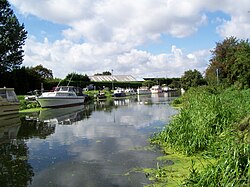
River Ancholme Riverancholmejm1.JPG
River Ancholme

The Fens and Anglian system is a collection of rivers in East Anglia in England that are navigable and for which the Environment Agency is the navigation authority. [1]

East Anglia region of the United Kingdom of Great Britain and Northern Ireland

East Anglia is a geographical area in the East of England. The area included has varied but the legally defined NUTS 2 statistical unit comprises the counties of Norfolk, Suffolk and Cambridgeshire, including the City of Peterborough unitary authority area. The name derives from the Anglo-Saxon kingdom of the East Angles, a tribe whose name originated in Anglia, northern Germany.

The Environment Agency (EA) is a non-departmental public body, established in 1995 and sponsored by the United Kingdom government's Department for Environment, Food and Rural Affairs (DEFRA), with responsibilities relating to the protection and enhancement of the environment in England.

A navigation authority is a company or statutory body which is concerned with the management of a navigable canal or river.

Many of the rivers drain The Fens between Cambridgeshire and Lincolnshire. These comprise River Glen, Great Ouse, River Nene, and River Welland. The Environment Agency is organising the Fens Waterways Link a major construction project to link these rivers for navigation. The first stage is the South Forty-Foot Drain. [2] [3]

The Fens Natural region in United Kingdom

The Fens, also known as the Fenlands, are a coastal plain in eastern England. This natural marshy region supported a rich ecology and numerous species, as well as absorbing storms. Most of the fens were drained several centuries ago, resulting in a flat, dry, low-lying agricultural region supported by a system of drainage channels and man-made rivers and automated pumping stations. There have been unintended consequences to this reclamation, as the land level has continued to sink and the dykes must be built higher to protect it from flooding.

Cambridgeshire County of England

Cambridgeshire is a county in the East of England, bordering Lincolnshire to the north, Norfolk to the north-east, Suffolk to the east, Essex and Hertfordshire to the south, and Bedfordshire and Northamptonshire to the west. The city of Cambridge is the county town. Modern Cambridgeshire was formed in 1974 as an amalgamation of the counties of Cambridgeshire and Isle of Ely and Huntingdon and Peterborough, the former covering the historic county of Cambridgeshire and the latter covering the historic county of Huntingdonshire and the Soke of Peterborough, historically part of Northamptonshire. It contains most of the region known as Silicon Fen.

Lincolnshire County of England

Lincolnshire is a county in eastern England, with a long coastline on the North Sea to the east. It borders Norfolk to the south east, Cambridgeshire to the south, Rutland to the south west, Leicestershire and Nottinghamshire to the west, South Yorkshire to the north west, and the East Riding of Yorkshire to the north. It also borders Northamptonshire in the south for just 20 yards (19 m), England's shortest county boundary. The county town is the city of Lincoln, where the county council has its headquarters.

Two East Anglian rivers in the grouping are physically separate from the Fens network. These are the River Ancholme in North Lincolnshire which connects to the Humber estuary, and the River Stour which is in Suffolk.

River Ancholme river in Lincolnshire, United Kingdom

The River Ancholme is a river in Lincolnshire, England, and a tributary of the Humber. It rises at Ancholme Head, a spring just north of the village of Ingham and immediately west of the Roman Road, Ermine Street. It flows east and then north to Bishopbridge, where it is joined by the Rase. North of Bishopbridge it flows through the market town of Brigg before draining into the Humber at South Ferriby. It drains a significant part of northern Lincolnshire between the Trent and the North Sea.

Humber Large tidal estuary in England

The Humber is a large tidal estuary on the east coast of Northern England. It is formed at Trent Falls, Faxfleet, by the confluence of the tidal rivers Ouse and Trent. From there to the North Sea, it forms part of the boundary between the East Riding of Yorkshire on the north bank and North Lincolnshire on the south bank. Although the Humber is an estuary from the point at which it is formed, many maps show it as the River Humber.

River Stour, Suffolk river in Suffolk, United Kingdom

The River Stour is a river in East Anglia, England. It is 47 miles (76 km) long and forms most of the county boundary between Suffolk to the north, and Essex to the south. It rises in eastern Cambridgeshire, passes to the east of Haverhill, through Cavendish, Bures, Sudbury, Nayland, Stratford St Mary, Dedham and flows through the Dedham Vale Area of Outstanding Natural Beauty. It becomes tidal just before Manningtree in Essex and joins the North Sea at Harwich.

The Environment Agency supervises craft registration for these rivers. [4]

See also

Related Research Articles

River Witham river in east of England

The River Witham is a river almost entirely in the county of Lincolnshire in the east of England. It rises south of Grantham close to South Witham at SK8818, passes Lincoln at SK9771 and at Boston, TF3244, flows into The Haven, a tidal arm of The Wash, near RSPB Frampton Marsh. The name "Witham" seems to be extremely old and of unknown origin. Archaeological and documentary evidence shows the importance of the Witham as a navigable river from the Iron Age onwards. From Roman times it was navigable to Lincoln, from where the Fossdyke was constructed to link it to the River Trent. The mouth of the river moved in 1014 following severe flooding, and Boston became important as a port.

River Welland river in east England

The River Welland is a lowland river in the east of England, some 65 miles (105 km) long. It drains part of the Midlands eastwards to The Wash. The river rises in the Hothorpe Hills, at Sibbertoft in Northamptonshire, then flows generally northeast to Market Harborough, Stamford and Spalding, to reach The Wash near Fosdyke. It is a major waterway across the part of the Fens called South Holland, and is one of the Fenland rivers which were laid out with washlands. There are two channels between widely spaced embankments with the intention that flood waters would have space in which to spread while the tide in the estuary prevented free egress. However, after the floods of 1947, new works such as the Coronation Channel were constructed to control flooding in Spalding and the washes are no longer used solely as pasture, but may be used for arable farming.

River Glen, Lincolnshire river in Lincolnshire, United Kingdom

The River Glen is a river in Lincolnshire, England with a short stretch passing through Rutland near Essendine.

River Hull river in the East Riding of Yorkshire in England

The River Hull is a navigable river in the East Riding of Yorkshire in Northern England. It rises from a series of springs to the west of Driffield, and enters the Humber Estuary at Kingston upon Hull. Following a period when the Archbishops of York charged tolls for its use, it became a free navigation. The upper reaches became part of the Driffield Navigation from 1770, after which they were again subject to tolls, and the section within the city of Hull came under the jurisdiction of the Port of Hull, with the same result.

South Forty-Foot Drain drainage canal in eastern England

The South Forty-Foot Drain, also known as the Black Sluice Navigation, is the main channel for the land-drainage of the Black Sluice Level in the Lincolnshire Fens. It lies in eastern England between Guthram Gowt and the Black Sluice pumping station on The Haven, at Boston. The Drain has its origins in the 1630s, when the first scheme to make the Fen land available for agriculture was carried out by the Earl of Lindsey, and has been steadily improved since then. Water drained from the land entered The Haven by gravity at certain states of the tide until 1946, when the Black Sluice pumping station was commissioned.

Car Dyke Ditch which runs along the western edge of the Fens in eastern England

The Car Dyke was, and to a large extent still is, an 85-mile (137 km) long ditch which runs along the western edge of the Fens in eastern England. It is generally accepted as being of Roman age and, for many centuries, to have been taken as marking the western edge of the Fens. There, the consensus begins to break down.

Lincolnshire is a large county in England with a sparse population distribution, which leads to problems funding all sorts of transport. The transport history is long and varied, with much of the road network still based on the Roman model, and the once extensive rail network a shadow of its former self.

Holland Fen with Brothertoft civil parish in Lincolnshire, England

Holland Fen with Brothertoft is a civil parish in Lincolnshire, England, consisting, as the name indicates, of Holland Fen and Brothertoft, but also includes the areas known as Pelhams Land, Harts Ground and Pepper Gowt Plot. The population of the civil parish at the 2011 census was 669.

Anglian Water water company that operates in the East of England

Anglian Water is a water company that operates in the East of England. Anglian Water is regulated under the United Kingdom Water Industry Act 1991.

Wilfholme Landing

Wilfholme Landing is located on the Driffield Navigation in the East Riding of Yorkshire, England. The navigation is still tidal at this point, and is often considered to still be the River Hull, although technically the Navigation starts at the point where the Aike Beck used to join the river, a little further downstream. It is 0.9 miles (1.4 km) from the hamlet of Wilfholme, and its main features are boat moorings, a farm and a pumping station. It is a popular spot for fishing, with anglers targeting resident roach, bream and perch.

Fens Waterways Link

The Fens Waterways Link is a project to improve recreational boating opportunities in the counties of Cambridgeshire and Lincolnshire, England. By a combination of improvements to existing waterways and the construction of new links a circular route between Lincoln, Peterborough, Ely and Boston is planned. The project is being organised by the Environment Agency and financed from the Regional Development Agency and the European Union.

Sleaford Navigation canal in Lincolnshire, England

The Sleaford Navigation was a 12.5 mile (20.1 km) canalisation of the River Slea in Lincolnshire, England, which opened in 1794. It ran from a junction with the River Witham, near Chapel Hill to the town of Sleaford through seven locks, most of which were adjacent to mills. Lack of finance meant that it stopped short of its intended terminus, but it gradually grew to be successful financially. The coming of the railways in 1857 led to a rapid decline, and it was officially abandoned by an act of Parliament in 1878, but remained open for a further three years. The lower part of it remained navigable until the 1940s, when it was blocked by a sluice.

East Anglian Waterways Association

The East Anglian Waterways Association is a waterway society and an umbrella organisation in East Anglia, England, UK.

Cambridgeshire Lodes man-made waterways in the county of Cambridgeshire, England

The Cambridgeshire Lodes are a series of man-made waterways, believed to be Roman in origin, located in the county of Cambridgeshire, England. Bottisham, Swaffham Bulbeck, Reach, Burwell, Wicken and Monks Lodes all connect to the River Cam, while Soham Lode connects to the River Great Ouse. All have been navigable historically, but some are no longer officially navigable.

Witham Navigable Drains drainage canals in Lincolnshire, England

The Witham Navigable Drains are located in Lincolnshire, England, and are part of a much larger drainage system managed by the Witham Fourth District Internal Drainage Board. The Witham Fourth District comprises the East Fen and West Fen, to the north of Boston, which together cover an area of 97 square miles (250 km2). In total there are over 438 miles (705 km) of drainage ditches, of which under 60 miles (97 km) are navigable. Navigation is normally only possible in the summer months, as the drains are maintained at a lower level in winter, and are subject to sudden changes in level as a result of their primary drainage function, which can leave boats stranded. Access to the drains is from the River Witham at Anton's Gowt Lock.

Black Sluice

The Black Sluice is the name given to the structure that controls the flow of the South Forty-Foot Drain into The Haven, at Boston, Lincolnshire, England.

Ewerby and Evedon is a civil Parish in North Kesteven, Lincolnshire, England. It includes the villages of Ewerby and Evedon, the hamlet of Haverholme, and is situated immediately west of Sleaford. The population of the civil parish at the 2011 census was 509.

References

  1. "Environment Agency Where to boat". Archived from the original on 23 January 2009. Retrieved 10 January 2009.
  2. Staff (20 July 2005). "Project is 'answer to the Broads'". BBC News. Retrieved 31 July 2008.
  3. Adams, John. "Fens Waterways Link". Environment Agency. Archived from the original on 31 August 2010. Retrieved 13 December 2008.
  4. Environment Agency Craft registration

Coordinates: 53°12′N0°32′W / 53.20°N 0.53°W / 53.20; -0.53

Geographic coordinate system Coordinate system

A geographic coordinate system is a coordinate system that enables every location on Earth to be specified by a set of numbers, letters or symbols. The coordinates are often chosen such that one of the numbers represents a vertical position and two or three of the numbers represent a horizontal position; alternatively, a geographic position may be expressed in a combined three-dimensional Cartesian vector. A common choice of coordinates is latitude, longitude and elevation. To specify a location on a plane requires a map projection.