Related Research Articles
The Holocene is the current geological epoch. It began approximately 9,700 years before the Common Era (BCE). It follows the Last Glacial Period, which concluded with the Holocene glacial retreat. The Holocene and the preceding Pleistocene together form the Quaternary period. The Holocene has been identified with the current warm period, known as MIS 1. It is considered by some to be an interglacial period within the Pleistocene Epoch, called the Flandrian interglacial.

Lake Bonneville was the largest Late Pleistocene paleolake in the Great Basin of western North America. It was a pluvial lake that formed in response to an increase in precipitation and a decrease in evaporation as a result of cooler temperatures. The lake covered much of what is now western Utah and at its highest level extended into present-day Idaho and Nevada. Many other hydrographically closed basins in the Great Basin contained expanded lakes during the Late Pleistocene, including Lake Lahontan in northwestern Nevada.
The Andean-Saharan glaciation, also known as the Early Palaeozoic Ice Age (EPIA), the Early Palaeozoic Icehouse, the Late Ordovician glaciation, the end-Ordovician glaciation, or the Hirnantian glaciation, occurred during the Paleozoic from approximately 460 Ma to around 420 Ma, during the Late Ordovician and the Silurian period. The major glaciation during this period was formerly thought only to consist of the Hirnantian glaciation itself but has now been recognized as a longer, more gradual event, which began as early as the Darriwilian, and possibly even the Floian. Evidence of this glaciation can be seen in places such as Arabia, North Africa, South Africa, Brazil, Peru, Bolivia, Chile, Argentina, and Wyoming. More evidence derived from isotopic data is that during the Late Ordovician, tropical ocean temperatures were about 5 °C cooler than present day; this would have been a major factor that aided in the glaciation process.
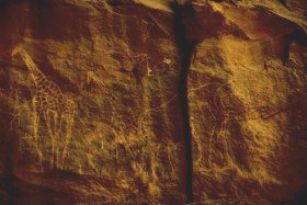
The Sahara pump theory is a hypothesis that explains how flora and fauna migrated between Eurasia and Africa via a land bridge in the Levant region. It posits that extended periods of abundant rainfall lasting many thousands of years in Africa are associated with a "wet-green Sahara" phase, during which larger lakes and more rivers existed. This caused changes in the flora and fauna found in the area. Migration along the river corridor was halted when, during a desert phase 1.8–0.8 million years ago (mya), the Nile ceased to flow completely and possibly flowed only temporarily in other periods due to the geologic uplift of the Nile River region.

Puyehue Lake, is an Andean piedmont lake on the border of Los Lagos Region with Los Ríos Region of Chile.

Haruj is a large volcanic field spread across 42,000–45,000 km2 (16,000–17,000 sq mi) in central Libya. It is one of several volcanic fields in Libya along with Tibesti, and its origin has been attributed to the effects of geologic lineaments in the crust.

The Bolshaya Chukochya or Chukochya is a river in the Sakha Republic (Yakutia) of the Russian Federation. It is 758 kilometres (471 mi) long, and has a drainage basin of 19,800 square kilometres (7,600 sq mi).
Protocyon is an extinct genus of large canid endemic to South and North America during the Late Pleistocene living from 781 to 12 thousand years ago.
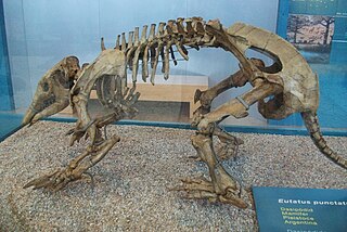
Eutatus is an extinct genus of large armadillos of the family Chlamyphoridae. It was endemic to South America from the Early Miocene to Late Pleistocene, living from 17.5 Ma-11,000 years ago, with possible survival into the early Holocene and existing for approximately 17.49 million years. Based on carbon isotope ratios, it is thought to have been an herbivore that fed on grasses.

Lake Tauca is a former lake in the Altiplano of Bolivia. It is also known as Lake Pocoyu for its constituent lakes: Lake Poopó, Salar de Coipasa and Salar de Uyuni. The lake covered large parts of the southern Altiplano between the Eastern Cordillera and the Western Cordillera, covering an estimated 48,000 to 80,000 square kilometres of the basins of present-day Lake Poopó and the Salars of Uyuni, Coipasa and adjacent basins. Water levels varied, possibly reaching 3,800 metres (12,500 ft) in altitude. The lake was saline. The lake received water from Lake Titicaca, but whether this contributed most of Tauca's water or only a small amount is controversial; the quantity was sufficient to influence the local climate and depress the underlying terrain with its weight. Diatoms, plants and animals developed in the lake, sometimes forming reef knolls.
Ouki was an ancient lake in the Bolivian Altiplano. Its existence was postulated in 2006 by a group of scientists who had subdivided the Lake Minchin lake cycle into several lake phases. The Lake Minchin cycle had been previously identified in 1904 as a now disappeared lake in the central Altiplano. Sediments attributed to Lake Minchin may rather be part of Ouki. The dating is uncertain, with radiocarbon and uranium-thorium dating yielding different dates spanning the time between 28,200 and 125,990 ± 9,580 years ago.
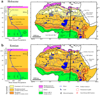
Lake Ptolemy is a former lake in Sudan. This lake formed during the Holocene in the Darfur region, during a time when the monsoon over Africa was stronger. The existence of the lake is dated between about 9,100–2,400 years before present. This lake could have reached a surface area of 30,750 square kilometres (11,870 sq mi), larger than present-day Lake Erie, although estimates of its size vary and it might have been much smaller. The shorelines in some places, insofar as they are recognizable, feature riparian landscapes and reeds. The lake was a freshwater lake replenished by groundwater and runoff from neighbouring mountains and might itself have been the source for the Nubian Sandstone Aquifer System. The lake featured a diverse ecosystem with a number of species, and possibly facilitated the spread of species between the Nile and Lake Chad.
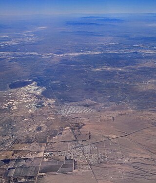
Lake Palomas is a former lake in New Mexico, United States, and Chihuahua, Mexico. This lake was relatively large and reached a size of about 9,100 square kilometres (3,500 sq mi) during its highstands. Preceded by Lake Cabeza de Vaca, it formed during the Pleistocene and continued into the Holocene, when several different lake phases occurred. Presently its basin is a major source of airborne dust in the region.

Lake Suguta is a former lake in Africa. It formed in the Suguta Valley, which is part of the East African Rift, south of Lake Turkana during the Holocene African humid period.
Lake Tengger is a paleolake in China. It formed within the Tengger Desert during the Pleistocene and in reduced form during the Holocene as well. It is not certain when it existed.

Miscanti Lake (Spanish: Laguna Miscanti) is a brackish water lake located in the altiplano of the Antofagasta Region in northern Chile. Cerro Miñiques volcano and Cerro Miscanti tower over this lake. This 13.5 square kilometres (5.2 sq mi) large heart-shaped lake has a deep blue colour and developed in a basin formed by a fault. South of Miscanti lies Laguna Miñiques, another lake which is separated from Miscanti by a lava flow that was emplaced there during the Pleistocene.

The African humid period is a climate period in Africa during the late Pleistocene and Holocene geologic epochs, when northern Africa was wetter than today. The covering of much of the Sahara desert by grasses, trees and lakes was caused by changes in the Earth's axial tilt; changes in vegetation and dust in the Sahara which strengthened the African monsoon; and increased greenhouse gases. During the preceding Last Glacial Maximum, the Sahara contained extensive dune fields and was mostly uninhabited. It was much larger than today, and its lakes and rivers such as Lake Victoria and the White Nile were either dry or at low levels. The humid period began about 14,600–14,500 years ago at the end of Heinrich event 1, simultaneously to the Bølling–Allerød warming. Rivers and lakes such as Lake Chad formed or expanded, glaciers grew on Mount Kilimanjaro and the Sahara retreated. Two major dry fluctuations occurred; during the Younger Dryas and the short 8.2 kiloyear event. The African humid period ended 6,000–5,000 years ago during the Piora Oscillation cold period. While some evidence points to an end 5,500 years ago, in the Sahel, Arabia and East Africa, the end of the period appears to have taken place in several steps, such as the 4.2-kiloyear event.
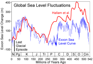
Paleohydrology, or palaeohydrology, is the scientific study of the movement, distribution, and quality of water on Earth during previous periods of its history. The discipline uses indirect evidence to infer changes in deposition rates, the existence of flooding, changes in sea levels, changes in groundwater levels and the erosion of rocks. It also deals with alterations in the floral and faunal assemblages which have come about in previous periods because of changes in hydrology.

Lake Modoc is a former lake in California and Oregon, in the location of present-day Upper Klamath Lake, Lower Klamath Lake and Tule Lake. It existed during the Pliocene and Pleistocene epochs, its formation probably influenced by volcanism and faulting. The bed of the former lake had plentiful resources for early humans, and today it is used for agriculture.

Lake Donggi Cona is a freshwater lake located 4090 m above sea level at the northeastern Tibetan Plateau.
References
- 1 2 Bridges, Edwin Michael (1990). World Geomorphology. Cambridge University Press. pp. 41–42. ISBN 978-0-521-28965-8.
- 1 2 3 Armitage, S.J.; Drake, N.A.; Stokes, S.; El-Hawat, A.; Salem, M.J.; White, K.; Turner, P.; McLaren, S.J. (2007). "Multiple phases of North African humidity recorded in lacustrine sediments from the Fazzan Basin, Libyan Sahara". Quaternary Geochronology. 2 (1–4): 181–186. doi:10.1016/j.quageo.2006.05.019.
- ↑ Geyh, Mebus A.; Thiedig, Friedhelm (2008). "The Middle Pleistocene Al Mahrúqah Formation in the Murzuq Basin, northern Sahara, Libya evidence for orbitally-forced humid episodes during the last 500,000 years". Palaeogeography, Palaeoclimatology, Palaeoecology. 257 (1–2): 1–21. doi:10.1016/j.palaeo.2007.07.001.
- 1 2 Smith, J. R. (2012). "Spatial and Temporal Variation in the Nature of Pleistocene Pluvial Phase Environments Across North Africa". In Hublin, Jean-Jacques; McPherron, Shannon P. (eds.). Modern Origins: A North African Perspective. Springer Science & Business Media. pp. 38–39. doi:10.1007/978-94-007-2929-2_3. ISBN 978-94-007-2929-2.
- ↑ Drake, N.A.; El-Hawat, A.S.; Turner, P.; Armitage, S.J.; Salem, M.J.; White, K.H.; McLaren, S. (2008). "Palaeohydrology of the Fazzan Basin and surrounding regions: The last 7 million years". Palaeogeography, Palaeoclimatology, Palaeoecology. 263 (3–4): 131–145. doi:10.1016/j.palaeo.2008.02.005.