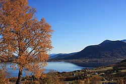
Vestnes is a municipality in Møre og Romsdal county, Norway. Vestnes is part of the traditional district of Romsdal. The administrative centre of the municipality is the village of Vestnes. Other villages in the municipality include Vikebukt, Vik, Øverås, Fiksdal, Tomrefjord, and Tresfjord.
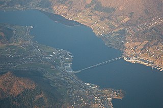
Ikornnes is a village in Sykkylven Municipality in Møre og Romsdal county, Norway. It is located along the Sykkylvsfjorden, about 4 kilometres (2.5 mi) east of Tusvik, 7 kilometres (4.3 mi) north of Straumgjerde, and about 3 kilometres (1.9 mi) west of the municipal center of Aure via the Sykkylven Bridge.

Larsnes is the administrative centre of the municipality of Sande in Møre og Romsdal county, Norway. It is located on the southwest side of the island of Gurskøya, about 8 kilometres (5.0 mi) east of the island of Kvamsøya, 8 kilometres (5.0 mi) southwest of the village of Gursken, and about 25 kilometres (16 mi) southwest of the town of Ulsteinvik.
Fiskåbygd or Fiskå is a coastal village that is also the administrative centre of Vanylven Municipality in Møre og Romsdal county, Norway. The village is located about 100 kilometres (62 mi) southwest of the city of Ålesund, about 12 kilometres (7.5 mi) east of the village of Myklebost, and about 30 kilometres (19 mi) southwest of the village of Rovdane. Fiskåbygd lies along the shores of the Vanylvsfjorden, east of the Stadlandet peninsula in Selje Municipality.

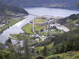
Sogndalsfjøra is the administrative center of the municipality of Sogndal in Sogn og Fjordane county, Norway. It is located where the river Sogndalselvi runs out in the Sogndalsfjorden, a branch of the large Sognefjorden. The village is located about 3.5 kilometres (2.2 mi) northwest of the village of Kjørnes, about 10 kilometres (6.2 mi) northwest of the village of Kaupanger, and about 31 kilometres (19 mi) southeast of the village of Fjærland.

Sande is the administrative centre of the municipality of Gaular in Sogn og Fjordane county, Norway. The village is located along the Gaula River, about 10 kilometres (6.2 mi) from where the river meets the Dalsfjorden. The 0.59-square-kilometre (150-acre) village has a population (2013) of 745, giving the village a population density of 1,263 inhabitants per square kilometre (3,270/sq mi). Sande Church is located in this village, serving the people of the central part of the municipality.
Skei is the administrative centre of the municipality of Jølster in Sogn og Fjordane county, Norway. The village is located at the northeastern end of the lake Jølstravatnet. Skei is 20 kilometres (12 mi) south of the village of Byrkjelo, 25 kilometres (16 mi) northeast of the villages of Vassenden/Langhaugane, and about 13 kilometres (8.1 mi) east of the village of Ålhus. Skei is located just west of Jostedalsbreen National Park. The village lies at the intersection of two major regional highways: European route E39 and Norwegian National Road 5.

Dale or Dale i Sunnfjord is the administrative centre of the municipality of Fjaler in Sogn og Fjordane county, Norway. The village is located at the mouth of the river Vassdalselva on the southern shore of the Dalsfjorden in the northern part of Fjaler, about 6.5 kilometres (4.0 mi) northeast of the village of Flekke and about 20 kilometres (12 mi) west of the village of Bygstad.

Vikedal or Vikadal is a village in Vindafjord municipality in Rogaland county, Norway. The village is located along the krosfjorden, about 7 kilometres (4.3 mi) south of the village of Sandeid and about 8 kilometres (5.0 mi) northwest of the village of Imslandsjøen. Vikedal Church is located in this village.

Etnesjøen or Etne is the administrative centre of Etne municipality in Hordaland county, Norway. The village is located at the inner end of the Etnefjorden, along the European route E134 highway, about 8 kilometres (5.0 mi) south of the village of Skånevik and about 10 kilometres (6.2 mi) northeast of the village of Ølensjøen.

Raudeberg is a village in Vågsøy Municipality in Sogn og Fjordane county, Norway. It is located on the east side of the island of Vågsøy. The villages of Refvika, Vedvika, and Langeneset are located a few kilometers to the north, and the town of Måløy is about 6 kilometres (3.7 mi) to the south. The island of Silda is located about 2 kilometres (1.2 mi) northeast of the village of Raudeberg. Nord-Vågsøy Church is located on the eastern edge of the village, right along the coast.
Bru or Ploganes is a village in the municipality of Kvam in Hordaland county, Norway. It's located in the Strandebarm area, on the northern shore of the Hardangerfjorden. It is located about 6 kilometres (3.7 mi) north of the village of Omastranda and about 10 kilometres (6.2 mi) northwest from the village of Kysnesstranda in Jondal Municipality.
Bryggja is a village in eastern part of Vågsøy Municipality in Sogn og Fjordane county, Norway. It is located on the mainland, along the northern shore of the Nordfjorden. The village is located about 15 kilometres (9.3 mi) east of the urban area of Måløy–Deknepollen–Tennebø in Vågsøy and it is about 25 kilometres (16 mi) west of Stårheim in neighboring Eid municipality. The small village of Totland lies just west of Bryggja.

Skei is a village and the administrative center of Surnadal Municipality in Møre og Romsdal county, Norway. The village is located at near the end of the Surnadalsfjorden along the river Surna. It is about 1 kilometre (0.62 mi) northeast of the village of Surnadalsøra and about 2 kilometres (1.2 mi) southeast of the village of Sylte. There are two churches near Skei: Øye Church and Ranes Church.

Hermansverk or Leikanger is a large village in the municipality of Leikanger in Sogn og Fjordane county, Norway. The village serves as the administrative centre of both the municipality of Leikanger and also Sogn og Fjordane county.

Selje is the administrative centre of Selje Municipality in Sogn og Fjordane county, Norway. The village is located at the southwestern base of the Stadlandet peninsula at the entrance to the Moldefjorden. The village lies about 17 kilometres (11 mi) northeast of the town of Måløy and about 65 kilometres (40 mi) southwest of the town of Ålesund. The small island of Selja lies just off the coast of the village. The 0.65-square-kilometre (160-acre) village has a population (2013) of 651, giving the village a population density of 1,002 inhabitants per square kilometre (2,600/sq mi). Selje Church is located in the village.
Naustdal is the administrative centre of Naustdal Municipality in Sogn og Fjordane county, Norway. The village is located on the northern shore of the Førdefjorden at the mouth of the river Nausta, which flows through the Naustdalen valley. The village sits about 12 kilometres (7.5 mi) northwest of the town of Førde and about 10 kilometres (6.2 mi) northeast of the village of Helle. Kletten Hill rises southeast of the village.

Jondal is the administrative centre of Jondal municipality in Hordaland county, Norway. The village is located on the southern shore of the Hardangerfjorden, about 55 kilometres (34 mi) southeast of the city of Bergen. It is located on the Folgefonna peninsula, about 12 kilometres (7.5 mi) northwest of the Folgefonna glacier in Folgefonna National Park. The village of Kysnesstranda lies about 15 kilometres (9.3 mi) to the south. The 0.59-square-kilometre (150-acre) village has a population (2013) of 379, giving the village a population density of 642 inhabitants per square kilometre (1,660/sq mi).