Finschhafen District

Last updated
Finschhafen District
Finschaffen.png
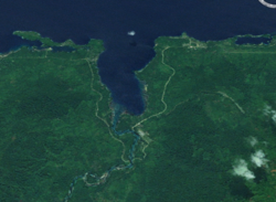
Satellite view
Papua New Guinea location map.svg
Red pog.svg
Finschhafen District
Location within Papua New Guinea
Coordinates: 6°36′S147°51′E / 6.600°S 147.850°E / -6.600; 147.850
Country Papua New Guinea
Province Morobe Province
Capital Finschhafen
LLGs
Government
   MP Rainbo Paita
Area
  Total2,642 km2 (1,020 sq mi)
Population
 (2011 census)
  Total54,672
  Density21/km2 (54/sq mi)
Time zone UTC+10 (AEST)

Finschhafen is a district on the north-east coast of the Morobe province of Papua New Guinea. It is named after the port town of the same name, Finschhafen.

The port was discovered (for Europeans) in 1884 by the German researcher Otto Finsch. In 1885 the German colony of German New Guinea created a town on the site and named it after the discoverer (-hafen = -harbor). Evangelical Lutheran missionaries, organized by Johann Flierl, settled near the town, establishing a Mission station at Simbang, and later at Sattelberg, approximately 5 kilometres (3 mi) away. Malaria was the bane of the town from the start. An epidemic in 1891 caused the colonists to briefly leave and only to return and then leave again ten years later in 1901. Other New Guinea towns were favoured instead, especially Rabaul.

During the Second World War Finschhafen was fought over by Japan and Australia, along with the United States. The Japanese first occupied the town on 10 March 1942. Australian forces, as part of US Rear Admiral Daniel E. Barbey's task force, landed nearby and seized the town in October 1943. (See New Guinea campaigns.)

Many of the original houses were destroyed during the war, and the city was re-developed somewhat further away, in the proximity of the military airport built by the Japanese. The airport was established as an important base for the US Army. Today this airport is used for civilian use (designation FIN).

The district is commonly spelled "Finschaffen" in PNG media. The US World War II base is usually written as "Finschafen" and occasionally "Finschaven" is also used.


Related Research Articles

Port Moresby Capital of Papua New Guinea

Port Moresby, also referred to as Pom City or simply Moresby, is the capital and largest city of Papua New Guinea and the largest city in the South Pacific outside of Australia and New Zealand. It is located on the shores of the Gulf of Papua, on the south-western coast of the Papuan Peninsula of the island of New Guinea. The city emerged as a trade centre in the second half of the 19th century. During World War II it was a prime objective for conquest by the Imperial Japanese forces during 1942–43 as a staging point and air base to cut off Australia from Southeast Asia and the Americas.

Rabaul Place in East New Britain, Papua New Guinea

Rabaul is a township in East New Britain province, on the island of New Britain, in the country of Papua New Guinea. It lies about 600 kilometres to the east of the island of New Guinea. Rabaul was the provincial capital and most important settlement in the province until it was destroyed in 1994 by falling ash from a volcanic eruption in its harbor.

Lae City in Morobe, Papua New Guinea

Lae is the capital of Morobe Province and is the second-largest city in Papua New Guinea. It is located near the delta of the Markham River and at the start of the Highlands Highway, which is the main land transport corridor between the Highlands region and the coast. Lae is the largest cargo port of the country and is the industrial hub of Papua New Guinea. The city is known as the Garden City and home of the University of Technology.

Madang Town in Madang Province, Papua New Guinea

Madang is the capital of Madang Province and is a town with a population of 27,420 on the north coast of Papua New Guinea. It was first settled by the Germans in the 19th century.

Ramu

The Ramu River is a major river in northern Papua New Guinea. The headwaters of the river are formed in the Kratke Range from where it then travels about 640 km (398 mi) northwest to the Bismarck Sea.

Morobe Province Place in Papua New Guinea

Morobe Province is a province on the northern coast of Papua New Guinea. The provincial capital and largest city is Lae. The province covers 33,705 km², with a population of 674,810, and since the division of Southern Highlands Province in May 2012 it is the most populous province. It includes the Huon Peninsula, the Markham River, and delta, and coastal territories along the Huon Gulf. The province has nine administrative districts. At least 101 languages are spoken, including Kâte and Yabem language. English and Tok Pisin are common languages in the urban areas, and in some areas pidgin forms of German are mixed with the native language.

Samarai

Samarai is an island and former administrative capital in Milne Bay Province, Papua New Guinea.

Territory of New Guinea Australian territory 1919–1975

The Territory of New Guinea was an Australian administered territory on the island of New Guinea from 1914 until 1975. In 1949, the Territory and the Territory of Papua were established in an administrative union by the name of the Territory of Papua and New Guinea. That administrative union was renamed as Papua New Guinea in 1971. Notwithstanding that it was part of an administrative union, the Territory of New Guinea at all times retained a distinct legal status and identity until the advent of the Independent State of Papua New Guinea.

II Corps (Australia) Australian Army corps

II Corps was an Australian Army corps, one of three that were raised by the Army during the Second World War. Formed in mid-1942 as part of defensive measures to protect the eastern coast of Australia from invasion, the corps was initially composed mainly of home defence troops drawn from the Militia. For a brief period in 1942, a US infantry division was also assigned to the corps prior to its dispatch to fight the Japanese in New Guinea.

Operation Mo

Operation Mo or the Port Moresby Operation was a Japanese plan to take control of the Australian Territory of New Guinea during World War II as well as other locations in the South Pacific with the goal of isolating Australia and New Zealand from their ally the United States. The plan was developed by the Imperial Japanese Navy and supported by Admiral Isoroku Yamamoto, the commander-in-chief of the Combined Fleet. The operation was ultimately abandoned.

Huon Peninsula

Huon Peninsula is a large rugged peninsula on the island of New Guinea in Morobe Province, eastern Papua New Guinea. It is named after French explorer Jean-Michel Huon de Kermadec. The peninsula is dominated by the steep Saruwaged and Finisterre and Cromwell Mountains. The nearest large town is the Morobe provincial capital Lae to the south, while settlements on the north coast include the former German town of Finschhafen, the district capital of Wasu, Malalamai and Saidor with its World War II era Saidor Airport.

Huon Peninsula campaign

The Huon Peninsula campaign was a series of battles fought in north-eastern Papua New Guinea in 1943–1944 during the Second World War. The campaign formed the initial part of an offensive that the Allies launched in the Pacific in late 1943 and resulted in the Japanese being pushed north from Lae to Sio on the northern coast of New Guinea over the course of a four-month period. For the Australians, a significant advantage was gained through the technological edge that Allied industry had achieved over the Japanese by this phase of the war, while the Japanese were hampered by a lack of supplies and reinforcements due to Allied interdiction efforts at sea and in the air.

Salamaua–Lae campaign

The Salamaua–Lae campaign was a series of actions in the New Guinea campaign of World War II. Australian and United States forces sought to capture two major Japanese bases, one in the town of Lae, and another one at Salamaua. The campaign to take the Salamaua and Lae area began after the successful defence of Wau in late January, which was followed up by an Australian advance towards Mubo as the Japanese troops that had attacked Wau withdrew to positions around Mubo. A series of actions followed over the course of several months as the Australian 3rd Division advanced north-east towards Salamaua. After an amphibious landing at Nassau Bay, the Australians were reinforced by a US regimental combat team, which subsequently advanced north up the coast.

Finschhafen Place in Morobe Province, Papua New Guinea

Finschhafen is a town 80 kilometers (50 mi) east of Lae on the Huon Peninsula in Morobe Province of Papua New Guinea. The town is commonly misspelt as Finschafen or Finschaven. During World War II, the town was also referred to as Fitch Haven in the logs of some U.S. Navy men.

20th Brigade (Australia) Infantry brigade of the Australian Army during World War II

The 20th Brigade was a brigade-sized infantry unit of the Australian Army. First raised in 1912 as a Militia formation to provide training under the compulsory training scheme, the brigade was later re-raised on 7 May 1940 as part of the all volunteer Second Australian Imperial Force for service during the World War II. The brigade was initially assigned to the 7th Division, but was later transferred to the 9th Division in early 1941. They subsequently took part in the Siege of Tobruk that year, and then the First and Second Battles of El Alamein in 1942. In early 1943, the brigade was returned to Australia to join the fighting against the Japanese in the Pacific. In late 1943, the brigade took part in the capture of Lae and then the Huon Peninsula campaign. Withdrawn to Australia in early 1944, its final campaign came during the Battle of North Borneo in the final months of the war. It was disbanded in February 1946.

Landing at Scarlet Beach

The Landing at Scarlet Beach took place in New Guinea during the Huon Peninsula campaign of the Second World War, involving forces from Australia, the United States and Japan. Allied forces landed at Scarlet Beach, north of Siki Cove and south of the Song River, to the east of Katika and about 10 kilometres (6.2 mi) north of Finschhafen. The capture of Finschhafen allowed the construction of air base and naval facilities to assist Allied air and naval forces to conduct operations against Japanese bases in New Guinea and New Britain.

Battle of Finschhafen

The Battle of Finschhafen was part of the Huon Peninsula campaign in New Guinea during World War II and was fought between Australian and Japanese forces. The fighting took place between 22 September and 24 October 1943 following the landing at Scarlet Beach, which was followed by a two-pronged advance on Finschhafen as the Australian 20th Infantry Brigade advanced on the town from the north, while the 22nd Infantry Battalion drove from the south, having advanced from the landing beaches east of Lae. After the capture of Finschhafen, the Japanese forces in the area withdrew towards Sattelberg where they sought to hold the Australians before launching a counteroffensive, which subsequently threatened the landing beach. This attack was repelled by American and Australian forces, with heavy casualties being inflicted on the Japanese. In the aftermath, the Australians went on the offensive, capturing Sattelberg, and then advancing towards the Wareo plateau.

2/15th Battalion (Australia) Former infantry battalion of the Australian Army

The 2/15th Battalion was an infantry battalion of the Australian Army that served during World War II. Formed in May 1940 primarily from Queensland volunteers, the battalion saw action in North Africa in 1941–1942 as part of the 20th Brigade, which was part of the 7th Division before being reassigned to the 9th Division.

History of Lae

As the township of Lae, in Morobe Province, Papua New Guinea is a relatively new entity, the history of the Lae environs is much older.

Battle of Madang

The Battle of Madang, fought between early February and late April 1944, was the break-out and pursuit phase of the Markham and Ramu Valley – Finisterre Range and Huon Peninsula campaigns, which were part of the wider New Guinea campaign of World War II. After overcoming the Japanese defences around Shaggy Ridge, the Australian forces descended the steep slopes of the Finisterre Range and pursued the withdrawing Japanese towards Bogadjim and then Madang on the north coast of New Guinea. There they linked up with US and Australian forces that had advanced along the coast from the Huon Peninsula, while the remnants of three Japanese divisions withdrew towards Wewak, where further fighting would take place throughout late 1944 and into 1945.