
Sandaun Province is the northwesternmost province of Papua New Guinea. It covers an area of 35,920 km2 and has a population of 248,411. The capital is Vanimo. In July 1998 the area surrounding the town Aitape was hit by an enormous tsunami caused by a Magnitude 7.0 earthquake which killed over 2,000 people. The five villages along the west coast of Vanimo towards the International Border are namely; Lido, Waromo, Yako, Musu and Wutung.

Morobe Province is a province on the northern coast of Papua New Guinea. The provincial capital and largest city is Lae. The province covers 33,705 km², with a population of 674,810, and since the division of Southern Highlands Province in May 2012 it is the most populous province. It includes the Huon Peninsula, the Markham River, and delta, and coastal territories along the Huon Gulf. The province has nine administrative districts. At least 101 languages are spoken, including Kâte and Yabem language. English and Tok Pisin are common languages in the urban areas, and in some areas pidgin forms of German are mixed with the native language.

Western Province is a coastal province in southwestern Papua New Guinea, bordering the Indonesian province of Papua. The provincial capital is Daru. The largest town in the province is Tabubil. Other major settlements are Kiunga, Ningerum, Olsobip and Balimo.

East Sepik is a province in Papua New Guinea. Its capital is Wewak. East Sepik has an estimated population of 433,481 people and is 43,426 km square in size.

The National Capital District of Papua New Guinea is the incorporated area around Port Moresby, which is the capital of Papua New Guinea. Although it is surrounded by Central Province, where Port Moresby is also the capital, it is technically not a part of that province. It covers an area of 240 km² and has a population of 364,125. It is represented by three open MPs and an NCD-wide representative in the National Parliament of Papua New Guinea who acts as Governor of the National Capital District; however, these MPs do not have the same powers as elsewhere in the country due to the role of the National Capital District Commission.
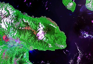
Huon Peninsula is a large rugged peninsula on the island of New Guinea in Morobe Province, eastern Papua New Guinea. It is named after French explorer Jean-Michel Huon de Kermadec. The peninsula is dominated by the steep Saruwaged and Finisterre and Cromwell Mountains. The nearest large town is the Morobe provincial capital Lae to the south, while settlements on the north coast include the former German town of Finschhafen, the district capital of Wasu, Malalamai and Saidor with its World War II era Saidor Airport.

Huon Gulf is a large gulf in eastern Papua New Guinea. It is bordered by Huon Peninsula in the north. Both are named after French explorer Jean-Michel Huon de Kermadec. Huon Gulf is a part of the Solomon Sea. Lae, capital of the Morobe Province, is located on the northern coast of the gulf.
Bukawa is an Austronesian language of Papua New Guinea.
Kala, also known as Kela, is an Austronesian language spoken by about 2200 people in several villages along the south coast of the Huon Gulf between Salamaua Peninsula and the Paiawa River, Morobe Province, Papua New Guinea.

This page is a list of local-level governments (LLGs) of Papua New Guinea. There are 326 LLGs comprising 6,112 wards as of 2018.

Papua New Guinea, a sovereign state in Oceania, is the most linguistically diverse country in the world. According to Ethnologue, there are 839 living languages spoken in the country. In 2006, Papua New Guinea Prime Minister Sir Michael Somare stated that "Papua New Guinea has 832 living languages ," Languages with statutory recognition are Tok Pisin, English, Hiri Motu, and Papua New Guinean Sign Language. Tok Pisin, an English-based creole, is the most widely spoken, serving as the country's lingua franca. Papua New Guinean Sign Language became the fourth officially recognised language in May 2015, and is used by the deaf population throughout the country.
This page is a list of districts of Papua New Guinea.

The Finisterre–Huon languages comprise the largest family within the Trans–New Guinea languages (TNG) in the classification of Malcolm Ross. They were part of the original TNG proposal, and William A. Foley considers their TNG identity to be established. The languages share a small closed class of verbs taking pronominal object prefixes some of which are cognate, strong morphological evidence that they are related.

Kabwum District is a district of the Morobe Province of Papua New Guinea. Its capital is Kabwum. The population of the district was 43,472 at the 2010 census.It is one of the mountainous places in Papua New Guinea. It is made up of four local level governments (LLGs) namely Komba, Selepet, Timbe or Deyamos and Yus. It shares its borders with the following districts of Morobe namely Finchhafen, Nawaeb and Tewai-Siassi. It also shares its border with Raicoast District of Madang Province. There are no direct road link from Lae City, the Provincial Capital to Kabwum District. So the way to get there from Lae is either by small planes or by ship and speed boat. If you choose plane then it will drop you directly at one of the local air-strips in the district. But if you choose ship or speed boats, then they will drop at Wasu where there is a highway road called Kabwum Highway linked to the mountainous part of the District. From there you can choose one of the local PMV to take you to your destiny.
Tewae-Siassi District is a district of the Morobe Province of Papua New Guinea. Its Head Quarter is Sialum. The population of the district was 54,340 at the 2011 census.
Nipa-Kutubu District is a district of the Southern Highlands Province of Papua New Guinea. Its capital is Nipa. The population was 147,005 at the 2011 census.
Jivevaneng is a town located on the Huon Peninsula, in Kotte Rural LLG, Morobe Province, Papua New Guinea.
Katika is a village on the Huon Peninsula, in Siki ward of Kotte Rural LLG, Morobe Province, Papua New Guinea.
The Bitoi River is a river located in Morobe Province, Papua New Guinea. The river flows into the Huon Gulf south of Salamaua.
Proto-Trans–New Guinea is the reconstructed proto-language ancestral to the Trans–New Guinea languages. Reconstructions have been proposed by Malcolm Ross and Andrew Pawley.
