
The snow goose is a species of goose native to North America. Both white and dark morphs exist, the latter often known as blue goose. Its name derives from the typically white plumage. The species was previously placed in the genus Chen, but is now typically included in the "gray goose" genus Anser.

The Kings River, historically called Wimmel-che by the Yokuts, is a 132.9-mile (213.9 km) river draining the Sierra Nevada mountain range in central California in the United States. Its headwaters originate along the Sierra Crest in and around Kings Canyon National Park and form the eponymous Kings Canyon, one of the deepest river gorges in North America. The river is impounded in Pine Flat Lake before flowing into the San Joaquin Valley southeast of Fresno. With its upper and middle course in Fresno County, the Kings River diverges into multiple branches in Kings County, with some water flowing south to the old Tulare Lake bed and the rest flowing north to the San Joaquin River. However, most of the water is consumed for irrigation well upstream of either point.

Lake Missoula was a prehistoric proglacial lake in western Montana that existed periodically at the end of the last ice age between 15,000 and 13,000 years ago. The lake measured about 7,770 square kilometres (3,000 sq mi) and contained about 2,100 cubic kilometres (500 cu mi) of water, half the volume of Lake Michigan.

The Nooksack River is a river in western Whatcom County of the northwestern U.S. state of Washington, draining extensive valley systems within the North Cascades around Mount Shuksan, Mount Baker and the Twin Sisters, and a portion of Fraser Lowland south of the Canada–United States border.

The Skagit River is a river in southwestern British Columbia in Canada and northwestern Washington in the United States, approximately 150 mi (240 km) long. The river and its tributaries drain an area of 1.7 million acres (690,000 hectares) of the Cascade Range along the northern end of Puget Sound and flows into the sound.

The Stillaguamish River is a river in the northwestern region of the U.S. state of Washington. It is mainly composed of two forks, the longer North Fork Stillaguamish and the South Fork Stillaguamish. The two forks join near Arlington. From there the Stillaguamish River proper flows for 22 miles (35 km) to Puget Sound. The river's watershed drains part of the Cascade Range north of Seattle.

The Yolo Bypass is one of the two flood bypasses in California's Sacramento Valley located in Yolo and Solano Counties. Through a system of weirs, the bypass diverts floodwaters from the Sacramento River away from the state's capital city of Sacramento and other nearby riverside communities.

The Kaweah River is a river draining the southern Sierra Nevada in Tulare County, California in the United States. Fed primarily by high elevation snowmelt along the Great Western Divide, the Kaweah begins as four forks in Sequoia National Park, where the watershed is noted for its alpine scenery and its dense concentrations of giant sequoias, the largest trees on Earth. It then flows in a southwest direction to Lake Kaweah – the only major reservoir on the river – and into the San Joaquin Valley, where it diverges into multiple channels across an alluvial plain around Visalia. With its Middle Fork headwaters starting at almost 13,000 feet (4,000 m) above sea level, the river has a vertical drop of nearly two and a half miles (4.0 km) on its short run to the San Joaquin Valley, making it one of the steepest river drainages in the United States. Although the main stem of the Kaweah is only 33.6 miles (54.1 km) long, its total length including headwaters and lower branches is nearly 100 miles (160 km).

Loess Bluffs National Wildlife Refuge is a National Wildlife Refuge in northwestern Missouri, United States, established in 1935 by President Franklin D. Roosevelt as a refuge and breeding ground for migratory birds and other wildlife.

Ross Dam is a 540-foot (160 m)-high, 1,300-foot (400 m)-long concrete thin arch dam across the Skagit River, forming Ross Lake. The dam is in Washington state, while Ross Lake extends 23 miles (37 km) north to British Columbia, Canada. Both dam and reservoir are located in Ross Lake National Recreation Area, is bordered on both sides by Stephen Mather Wilderness and combined with Lake Chelan National Recreation Area they make up North Cascades National Park Complex.

Folsom Dam is a concrete gravity dam on the American River of Northern California in the United States, about 25 mi (40 km) northeast of Sacramento. The dam is 340 ft (100 m) high and 1,400 ft (430 m) long, flanked by earthen wing dams. It was completed in 1955, and officially opened the following year.

The Columbia Slough is a narrow waterway, about 19 miles (31 km) long, in the floodplain of the Columbia River in the U.S. state of Oregon. From its source in the Portland suburb of Fairview, the Columbia Slough meanders west through Gresham and Portland to the Willamette River, about 1 mile (1.6 km) from the Willamette's confluence with the Columbia. It is a remnant of the historic wetlands between the mouths of the Sandy River to the east and the Willamette River to the west. Levees surround much of the main slough as well as many side sloughs, detached sloughs, and nearby lakes. Drainage district employees control water flows with pumps and floodgates. Tidal fluctuations cause reverse flow on the lower slough.
Skagit City was a town on the western bank of the South Fork Skagit River, less than a mile southeast of where the river forks north and south, in the U.S. state of Washington. The Barker's Trading Post along the river, opened in 1869, was partially or fully responsible for drawing people to settle at the townsite, which became an important river transportation center during the late 1800s, most notably in 1872. The city prospered until shortly before the 1880s, after river access to the upstream community of Mount Vernon, Washington was established and Mount Vernon began to prosper. By 1906, only one business remained in the entire town, and soon after World War II the town disappeared entirely. Today, the unincorporated community of Cedardale is the closest community to the former townsite at 2.4 miles (3.9 km) distance, and the name "Skagit City" has become simply a placename on the northeastern tip of Fir Island near where two distributaries diverge and carry Skagit River water into Skagit Bay, which branches off the Strait of Juan de Fuca. Skagit City is sometimes confused with the nearby tiny hamlet of Skagit Forks, which was just to the northwest at the divergence of the North and South Forks of the Skagit River. The town played an integral part in the settlement of Skagit County.
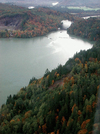
Lake Shannon is a long, narrow reservoir on the Baker River in Skagit County, Washington in the United States. Formed in the 1920s by the construction of an arch dam just above the town of Concrete, the lake is approximately 7.5 miles (12 km) long and averages 0.6 miles (1 km) wide when full. Located just outside the western boundary of North Cascades National Park, Lake Shannon serves as the lower reservoir for Puget Sound Energy's Baker River Hydroelectric Project.

The Willamette River is a 187-mile (301 km) tributary of the Columbia River in the U.S. state of Oregon. The upper tributaries of the Willamette originate in mountains south and southeast of the twin cities of Eugene and Springfield. Formed by the confluence of the Middle Fork Willamette River and Coast Fork Willamette River near Springfield, the main stem meanders generally north from source to mouth. The river's two most significant course deviations occur at Newberg, where the stream turns sharply east, and about 18 miles (29 km) downriver from Newberg, where it turns north again. Near its mouth, the river splits into two channels that flow around Sauvie Island. The main channel enters the Columbia about 101 miles (163 km) from the larger stream's mouth on the Pacific Ocean, and the smaller Multnomah Channel enters the Columbia about 14.5 miles (23.3 km) further downstream near St. Helens in Columbia County.

The Middle Fork American River is one of three forks that form the American River in Northern California. It drains a large watershed in the high Sierra Nevada west of Lake Tahoe and northeast of Sacramento in Placer and El Dorado Counties, between the watersheds of the North Fork American River and South Fork American River. The Middle Fork joins with the North Fork near Auburn and they continue downstream to Folsom Lake as the North Fork, even though the Middle Fork carries a larger volume of water.

The Salt River is a formerly navigable hanging channel of the Eel River which flowed about 9 miles (14 km) from near Fortuna and Waddington, California, to the estuary at the Pacific Ocean, until siltation from logging and agricultural practices essentially closed the channel. It was historically an important navigation route until the early 20th century. It now intercepts and drains tributaries from the Wildcat Hills along the south side of the Eel River floodplain. Efforts to restore the river began in 1987, permits and construction began in 2012, and water first flowed in the restored channel in October 2013.
Leque Island is a small island located in Snohomish County, in Washington, United States. It can be found just beneath the bridge between Camano Island and Stanwood, at the mouth of the Stillaguamish River, in Puget Sound.
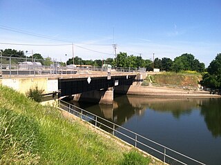
The Delta Cross Channel is a facility in California's Sacramento-San Joaquin Delta that diverts water from the Sacramento River. The facility was built in 1951 in Walnut Grove, California.


