
Coahuila, formally Coahuila de Zaragoza, officially the Free and Sovereign State of Coahuila de Zaragoza, is one of the 32 states of Mexico.

Piedras Negras is a city and seat of the surrounding municipality of the same name in the Mexican state of Coahuila. It stands at the northeastern edge of Coahuila on the Mexico–United States border, across the Rio Grande from Eagle Pass in the U.S. state of Texas. In the 2015 census the city had a population of 163,595 inhabitants, while the metropolitan area had a population of 245,155 inhabitants. The Piedras Negras and the Eagle Pass areas are connected by the Eagle Pass–Piedras Negras International Bridge, Camino Real International Bridge, and the Union Pacific International Railroad Bridge.
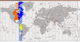
UTC−05:00 is an identifier for a time offset from UTC of −05:00. In North America, it is observed in the Eastern Time Zone during standard time, and in the Central Time Zone during the other eight months. The western Caribbean uses it year round.
The governmental structures of Nuevo León, a Mexican state, are organized according to article 30 of the state constitution, which provides for a republican, representative and popular government, divided into three independent branches that cannot be joined together in a single person or institution. Nuevo León's relation with the federal government of Mexico places it in a similar relation to that federal government as any other Mexican state, but it retains certain aspects of sovereignty with respect to other Mexican states and even toward foreign countries, especially with reference to its own internal affairs.
Jiménez is a town and seat of the municipality of Jiménez in the Mexican state of Coahuila, at an altitude of 250 meters above sea level. It is located on the confluence of the Río San Diego and the Rio Grande bordering with the U.S. state of Texas. It had a population of 1,160 inhabitants in the 2010 census, and is, unusually for a Mexican municipal seat, the second-largest locality in the municipality, after the town of San Carlos.
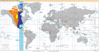
UTC−06:00 is an identifier for a time offset from UTC of −06:00. In North America, it is observed in the Central Time Zone during standard time, and in the Mountain Time Zone during the other eight months. Several Latin American countries and a few other places use it year-round.
XHPNW-TDT is an independent television station in Piedras Negras, Coahuila. The station brands itself as Super Channel 12.

The Seventh Federal Electoral District of Chihuahua(VII Distrito Electoral Federal de Chihuahua) is one of the 300 Electoral Districts into which Mexico is divided for the purpose of elections to the federal Chamber of Deputies and one of nine such districts in the state of Chihuahua.

The Ninth Federal Electoral District of Chihuahua(IX Distrito Electoral Federal de Chihuahua) is one of the 300 Electoral Districts into which Mexico is divided for the purpose of elections to the federal Chamber of Deputies and one of nine such districts in the state of Chihuahua.
The First Federal Electoral District of Nayarit(I Distrito Electoral Federal de Nayarit) is one of the 300 Electoral Districts into which Mexico is divided for the purpose of elections to the federal Chamber of Deputies and one of three such districts in the state of Nayarit.

The Second Federal Electoral District of Coahuila(II Distrito Electoral Federal de Coahuila) is one of the 300 Electoral Districts into which Mexico is divided for the purpose of elections to the federal Chamber of Deputies and one of seven such districts in the state of Coahuila.

The Seventh Federal Electoral District of Coahuila(VII Distrito Electoral Federal de Coahuila) is one of the 300 Electoral Districts into which Mexico is divided for the purpose of elections to the federal Chamber of Deputies and one of seven such districts in the state of Coahuila.

Zaragoza is one of the 38 municipalities of Coahuila, a state in north-eastern Mexico. The municipal seat lies at Zaragoza. The municipality covers an area of 8183.5 km². It is near the Mexico–US border with Texas. It is one of the cities in the "5 manantiales" region in northern Coahuila. The celebrations commemorating Zaragoza's founding on 1 February 1753 are a popular attraction, and feature a traditional "cabalgata" or horse trail ride with horse pulled vintage buggies. On 7 August 1827, the name of the town was changed to San Fernando de Rosas, and to Zaragoza on the 27 February 1868.
This is a list of events that happened in 2011 in Mexico. The article also lists the most important political leaders during the year at both federal and state levels.

Legislative elections were held in Mexico on 7 June 2015, alongside municipal elections.
Events in the year 1970 in Mexico.
Events in the year 1969 in Mexico.
Francisco Saracho Navarro is a Mexican politician from the Institutional Revolutionary Party. He serves in the Chamber of Deputies for the LXIII Legislature of the Mexican Congress from the First Federal Electoral District of Coahuila.
The 2021 Coahuila elections are scheduled to be held on June 6, 2021 to decide the 38 Municipalities top level positions around the state. Municipal elections in Coahuila allow the people to elect members of the Ayuntamiento in each municipality. These are called the 38 Municipal Presidents (Mayors), 74 sindicos and 400 regidores. The term of office of councilors, the mayor and his deputies is, in principle, three years. The municipal elections are sanctioned by Electoral Institute of Coahuila since its creation in 2016.
