Fitzroy Street, Melbourne

Last updated

Fitzroy Street

Midsumma.jpg
Looking east up Fitzroy Street to the corner of Grey Street, during the Midsumma Pride March in 2008
Fitzroy Street, Melbourne
Australia Victoria metropolitan Melbourne location map.svg
Red pog.svg
West end
Red pog.svg
East end
Coordinates
General information
TypeStreet
Length1.1 km (0.7 mi) [1]
Major junctions
West endThe Esplanade
St Kilda, Melbourne
 
East endAustralian state route 3.svg St Kilda Road
Australian state route 29.svg Punt Road
St Kilda, Melbourne
Location(s)
LGA(s) City of Port Phillip

Fitzroy Street is the major thoroughfare of the beachside Melbourne suburb of St Kilda. Its fortunes have risen and fallen along with that of St Kilda itself, from wealthy residential district to a popular working and middle class beachside entertainment district, to cheap and seedy, and popular again in the late 20th century. In recent years Fitzroy Street itself has gone from a popular restaurant strip to the situation in 2017 where only a few restaurants remain amongst kebab shops and convenience stores catering the backpackers and many empty shopfronts. [2] It is named after Charles Augustus FitzRoy, Governor of New South Wales (which included the area of Victoria) in 1842 when St Kilda was first subdivided.

Contents

Route

Fitzroy Street is a wide street running generally downhill from St Kilda Junction to the beach foreshore, the most direct road route from the Melbourne central business district to the popular bay beach. It is an unusually wide street, with wide footpaths and space for a separate tram line right of way, and the two sides have quite different characters. It is sometimes closed to traffic for major events such as the St Kilda Festival, the Melbourne Marathon and the Midsumma Pride March.

The eastern section of the street from St Kilda Junction to Grey Street comprises medium rise apartment buildings on the south side overlooking Albert Park and Lake and the Junction Oval on the north. The corner of Grey Street is dominated by The George, originally a large hotel, now apartments and hospitality spaces. [3]

From Grey Street to The Esplanade, the south side is entirely lined with shops, many with apartments or hotels above. Leo's Spaghetti Bar is the most well known eatery, an early Italian restaurant and gelateria which was opened during the 1956 Summer Olympics.

Opposite The George is the former St Kilda railway station, opened in 1857, converted to retail and other uses when the train line was converted to become part of route 96 in 1987, which continues into Fitzroy Street, where it joins route 16.

Tram routes 16 and 96 run down the street.

History

Like St Kilda as a whole, Fitzroy Street in the middle to late 19th century was mainly a wealthy residential address, lined with grand houses, terraces and hotels. During the interwar years, the mansions were converted to flats or private hotels, and shops built in their front gardens, while others were replaced by flats with shops on the ground floor. The prominent Art Deco Prince of Wales Hotel replaced a Victorian era hotel of the same name on the corner of Acland Street in 1937. [4] In the mid 20th century this development trend was continued, resulting in a continuous row of shops.

From the 1960s to the 1980s, Fitzroy Street became the public face of the transformation of St Kilda from popular seaside entertainment and apartment living to red light district and cheap flats. The street featured cheap late night eateries, prostitution, drag cabaret shows, and The George hotel (renamed The Seaview) became a major venue for the punk and alternative music scene. [5] The suburb and the street, and particularly the Prince of Wales Hotel, [6] became a centre of LGBT culture in Melbourne in the 1980s, an association that continues as the location of the Midsumma Festival since 1995, and in 2017 with the announcement that the Victorian Pride Centre would be located there. [7]

In March 2017, the Gatwick Private Hotel was purchased by the Nine Network for filming of the 2018 season of The Block . [8]

The passing of the Road Management Act 2004 [9] granted the responsibility of overall management and development of Victoria's major arterial roads to VicRoads: in 2013, VicRoads re-declared the road as Fitzroy Street (Arterial #5932), beginning at Canterbury Road and ending at Nepean Highway through St Kilda; [10] the remainder of the street west to The Esplanade remains undeclared.

See also

Australia road sign W5-29.svg   Australian Roadsportal

Related Research Articles

<span class="mw-page-title-main">St Kilda, Victoria</span> Suburb of Melbourne, Victoria, Australia

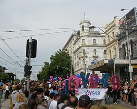
St Kilda is an inner seaside suburb in Melbourne, Victoria, Australia, 6 km south-east of the Melbourne central business district, located within the City of Port Phillip local government area. St Kilda recorded a population of 19,490 at the 2021 census.

<span class="mw-page-title-main">City of Port Phillip</span> Local government area in Victoria, Australia

The City of Port Phillip is a local government area of Victoria, Australia on the northern shores of Port Phillip, south of Melbourne's central business district. It has an area of 20.7 km² and had a population of 113,200 in June 2018.

<span class="mw-page-title-main">St Kilda West, Victoria</span> Suburb of Melbourne, Victoria, Australia

St Kilda West is an inner suburb in Melbourne, Victoria, Australia, 5 km south of Melbourne's Central Business District, located within the City of Port Phillip local government area. St Kilda West recorded a population of 2,951 at the 2021 census.

<span class="mw-page-title-main">Fitzroy, Victoria</span> Suburb of Melbourne, Victoria, Australia

Fitzroy is an inner-city suburb in Melbourne, Victoria, Australia, 3 km (1.9 mi) north-east of Melbourne's Central Business District, located within the City of Yarra local government area. Fitzroy recorded a population of 10,431 at the 2021 census.

<span class="mw-page-title-main">St Kilda Road</span> Road in Melbourne, Victoria, Australia

St Kilda Road is a street in Melbourne, Victoria, Australia. It is part of the locality of Melbourne which has the postcode of 3004, and along with Swanston Street forms a major spine of the city.

<span class="mw-page-title-main">St Kilda light rail station</span> Tram stop in Victoria, Australia

St Kilda station is a current tram stop and former railway station, located in the Melbourne suburb of St Kilda, Australia, and was the terminus of the St Kilda railway line in the Melbourne suburban rail system. It is one of the oldest surviving railway station buildings in Victoria. The building is currently used as retail premises, while the platform serves as stop 132 on tram route 96.

<span class="mw-page-title-main">Melbourne tram route 112</span>

Melbourne tram route 112 was operated by Yarra Trams on the Melbourne tram network from West Preston to St Kilda. The 18 kilometre route was operated out of East Preston depot with A, B and D2 class trams.

<span class="mw-page-title-main">Melbourne tram route 96</span>

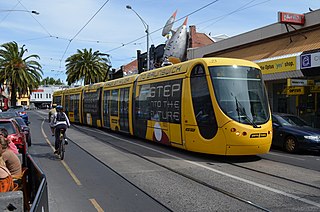
Melbourne tram route 96 is operated by Yarra Trams on the Melbourne tram network from Brunswick East to St Kilda Beach. The 13.9 kilometre route is operated out of Southbank depot with C2 and E class trams.

<span class="mw-page-title-main">Acland Street</span> Road in Melbourne, Australia

<span class="mw-page-title-main">Hoddle Highway</span> Highway in Melbourne, Victoria

Hoddle Highway is an urban highway in Melbourne linking CityLink and the Eastern Freeway, itself a sub-section of Hoddle Main Road. Both these names are not widely known to most drivers, as the entire allocation is still best known as by the names of its constituent parts: Hoddle Street, Punt Road and Barkly Street. This article will deal with the entire length of the corridor for sake of completion, as well to avoid confusion between declarations.

<span class="mw-page-title-main">Brunswick Street, Melbourne</span> Street in Melbourne, Australia

Brunswick Street is a street in inner northern Melbourne, known for cafés, live music venues and alternative fashion shops.

<span class="mw-page-title-main">St Kilda Junction</span> Road intersection in St Kilda, Australia

St Kilda Junction is a major intersection in Melbourne, Australia. It is in the suburb of St Kilda, bordering Windsor and St Kilda East, and is the meeting point of the major roads Punt Road, St Kilda Road, Dandenong Road/Queens Way/Princes Highway and Fitzroy Street.

<span class="mw-page-title-main">Chapel Street, Melbourne</span> Street in Melbourne, Australia

Chapel Street is a street in Melbourne, Victoria, running along the inner suburbs of South Yarra, Prahran, Windsor, St Kilda and St Kilda East.

<span class="mw-page-title-main">Victoria Street, Melbourne</span> Road in Melbourne, Victoria

Victoria Street is one of the major thoroughfares of inner Melbourne, running east–west for over six kilometres between Munster Terrace in North Melbourne and the Yarra River. The road is known as Victoria Parade for over one-and-a-half kilometres of its length, distinguishable with a wide reservation and tramway down the middle.

<span class="mw-page-title-main">Melbourne tram route 3</span>

Melbourne tram route 3 is operated by Yarra Trams on the Melbourne tram network from Melbourne University to Malvern East. The 14.9-kilometre (9.3 mi) route is operated out of Glenhuntly depot with Z and B class trams. Until 29 October 2023, route 3 operated as route 3a on weekends and diverted via St Kilda Beach.

St Kilda Beach is a beach located in St Kilda, Port Phillip, Victoria, Australia, 6 kilometres (3.7 mi) south from the Melbourne city centre. It is Melbourne's most famous beach. The beach is a sandy beach about 700 metres (2,300 ft) long between St Kilda Marina and St Kilda Harbour along Jacka Boulevard and St Kilda Esplanade. It is located at the north-east corner of Port Phillip and is protected from ocean swell, though still affected by strong westerly winds. With Port Phillip Bay being open to the sea, St Kilda Beach is subject to regular tides.

<span class="mw-page-title-main">Beach Road, Melbourne</span> Road in Melbourne, Victoria

Beach Road is a coastal suburban road in Melbourne, Australia that runs along the northeastern shore of Melbourne's Port Phillip Bay, starting at the T-junction with Beacon Street in Port Melbourne to its southern end at the junction with Nepean Highway in Mordialloc.

<span class="mw-page-title-main">Melbourne tram route 12</span> Tram route in metropolitan Melbourne, Victoria, Australia

Melbourne tram route 12 is operated by Yarra Trams on the Melbourne tram network from Victoria Gardens Shopping Centre to St Kilda. The 16.2-kilometre (10.1 mi) is operated out of Southbank depot with A class trams.

The Melbourne tram network began in 1884 with the construction of the Fairfield Horse Tramway. However, the purpose of the line was to increase land prices in the area, and it soon closed during the depression in 1890. The first genuine attempt to construct a tramway network was the construction of the Richmond cable tram line by the Melbourne Tramway & Omnibus Company in 1885. Over the next few years, 16 more cable tram lines were constructed, as well as numerous other horse tramways. The depression of the early 1890s slowed further expansion of the cable network. The first electric tram line was the Box Hill and Doncaster tramway which opened in 1889. This was a pioneering line in what was then the countryside and thus didn't receive much patronage. It closed in 1896. The next attempt at an electric tramway was Victorian Railways' St Kilda to Brighton line, which opened in 1906. Later that year, the North Melbourne Electric Tramway & Lighting Company opened lines to Essendon and Maribyrnong. Many local councils formed their own tramway trusts and built tramways within their own constituency. The most successful of these was the Prahran & Malvern Tramways Trust.

References

  1. Google (15 December 2021). "Fitzroy Street" (Map). Google Maps . Google. Retrieved 15 December 2021.
  2. "Fitzroy Street's decline a tale of old and new St Kilda". The Age . Retrieved 18 March 2017.
  3. "Pots Punks and Punters". St Kilda Historical Series. St Kilda Historical Society. Retrieved 18 March 2017.
  4. "Pots Pubs and Punkers". St Kilda Historical Series. St Kilda Historical Society. Retrieved 18 March 2017.
  5. "Pots, Punks and Punters". St Kilda Historical Series. St Kilda Historical Society. Retrieved 18 March 2017.
  6. "The POW starts to bend". St Kilda Music Walking Tours 2013. Retrieved 18 March 2017.
  7. "Fitzroy St to become home to Australia's first Australia's first Pride Centre". Port Phillip Leader. 17 March 2017. Retrieved 18 March 2017.
  8. Channel Nine confirms Gatwick Hotel purchased for future season of The Block The Age 22 March 2017
  9. State Government of Victoria. "Road Management Act 2004" (PDF). Government of Victoria. Archived (PDF) from the original on 18 October 2021. Retrieved 19 October 2021.
  10. "Register of Public Roads (Part A) 2015". VicRoads. pp. 944–5. Archived from the original on 1 May 2020. Retrieved 19 October 2021.