Calheta is a municipality on the island of São Jorge, in the Portuguese autonomous region of Azores. The municipality includes the eastern portion of the island of São Jorge and borders the municipality of Velas. The population in 2011 was 3,773, in an area of 126.26 km2.

Santa Cruz das Flores is a municipality situated in the north half of the island of Flores, in the Portuguese archipelago of the Azores. Situated in the sparsely populated Western Group, the population in 2021 was 2,020 inhabitants in an area that covers approximately 70.91 square kilometres (27.38 sq mi), bordering the southern municipality of Lajes das Flores.

Horta is a municipality and city in the Portuguese archipelago of the Azores encompassing the island of Faial. The population in 2011 was 15,038 in an area of 173.06 square kilometres (66.82 sq mi) The city of Horta itself has a population of about 7,000.

Faial Island, also known as Fayal Island, is a Portuguese island of the Central Group or Grupo Central of the Azores, in the Atlantic Ocean.

Angústias is one of the three freguesia that comprise the urban area of the city of Horta, on the island of Faial in the Portuguese archipelago of the Azores. This is an economically active, densely populated area. The population in 2011 was 2,418, in an area of 3.79 km2. Due to its commercial nature, the parish is one of the island's primary destinations for tourism, due to the concentration of historical sights and shopping. It contains the localities Caminho do Meio, Courelas, Pasteleiro, Port Pim, Termo da Igreja and Vigia.
Cedros is a freguesia in the northern part of the municipality of Horta on the island of Faial in the Portuguese archipelago of the Azores. The population in 2011 was 907, in an area of 24.5 square kilometres (264,000,000 sq ft). The northernmost parish on the island, it is located 19 kilometres (12 mi) northwest of Horta and is linked via the Estrada Regional E.R. 1-1ª roadway to the rest of the island. The tree-covered hills and pasture-lands cover the interior, and hedged farmlands extend to the Atlantic coastline cliffs, a natural plateau above the sea, that was settled by early Flemish and Spanish colonists in the late part of the 15th century. Primarily an agricultural community, the population is comparable in size to other parishes on the island, though this has decreased by half since the 1950s. Today, it remains an agricultural centre of the island of Faial, anchored by the Cooperativa Agrícola dos Lactícinios do Faial, one of the primary rural industries on the island, responsible for sales of milk, cheese and butter.

Conceição is a freguesia in the municipality of Horta in the Portuguese Azores. The population in 2011 was 1,138, in an area of 3.08 km². It is the second smallest parish within the administration of Horta.

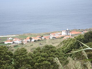
Feteira is a civil parish in the southern part of the municipality of Horta, on the island of Faial in the Portuguese archipelago of the Azores. The population in 2011 was 1,899, in an area of 14.46 km2. It occupies the southern foothills of the Caldeira Volcano, along the coast. The name Feteira is derived from the Portuguese word for "fern", and indicates a "location of [many] ferns"; the name likely refers to the original colonists' discovery of this area covered with ferns.

Matriz is a freguesia in the municipality of Horta, in the Portuguese Azores, which is part of the urbanized core of the city of Horta. The population in 2011 was 2,562, in an area of 1.81 km². It is the smallest and most populous parish on the island. It contains the localities Matriz and Dutras.

Praia do Almoxarife is a freguesia in the municipality (concelho) of Horta, of the Portuguese archipelago of the Azores. The population in 2011 was 834, in an area of 9.20 km2. Although it was the beachhead of early settlement on the island, its population has not grown significantly since it was settled. It has become an important summer destination and tourist center for its long black sand beach.

Ribeira Grande is a municipality in the northern part of the island of São Miguel in the Portuguese Azores. The population in 2011 was 32,112, in an area of 180.15 km2. The municipal seat is located in the civil parish of Matriz, with a population of about 4000 inhabitants, part of the urbanized core of what is commonly referred to as the city of Ribeira Grande.

The Faial-Pico Channel is an 8.3 kilometres (5.2 mi) long channel that separates the islands of Faial and Pico in the central group of the archipelago of the Azores. The strait is divided into various depressions, calderas and micro-systems, referred to as Baixas.

D. Willem van der Haegen, or Willem De Kersemakere, known in Portuguese as Guilherme da Silveira, or Guilherme Casmaca, was a Flemish-born Azorean entrepreneur, explorer, and colonizer. He was a pioneer colonizer in Azorean history and his descendants formed part of the original Azorean nobility.

Joost De Hurtere, also known by several transliterations was the first settler, and captain-major of the Portuguese island of Faial in the Azores. After 1482, the island of Pico was also incorporated into his captaincy. His son, Joss de Utra would later inherit the captaincy from him after his death.

Fort of Santa Cruz, is a 16th-century fortification located in the civil parish of Angústias, municipality of Horta, on the island of Faial in the Portuguese Azores. Occasionally referred to as the Castelo de Santa Cruz by locals, it is situated in the historic centre of the city, on the edge of Horta Bay. It was constructed to work in conjunction with the Fort of Bom Jesus at the mouth of the Ribeira da Conceição and Fort of Greta along the coast of the extinct spatter cone Monte da Guia, to defend the entrance to the harbour and southern access to the Bay.

The Nature Park of Faial, or simply Faial Nature Park (PNF), developed from the intention of better managing the protected areas of the island of Faial, and was instituted by the Secretaria Regional do Ambiente e do Mar of the Autonomous Regional Government of the Azores.

The Botanical Garden of Faial is an ecological garden, component of the Faial Nature Park, established in 1986 to educate and protect the biodiversity common on Faial, an island of the Azores archipelago.

The Fort of Greta is a medieval fortification, whose remnants are located on the cinder cone of Monte da Guia, along the southern coast of the civil parish of Angústias, in Horta, island of Faial, in the Portuguese Azores.
The Church of Santa Bárbara is a church in the civil parish of Cedros, municipality of Horta, on the Portuguese island of Faial in the archipelago of the Azores. Its parish falls within the Roman Catholic Diocese of Angra, and serves the parishioners of the northern coast from the border with Salão to Ribeira Funda.

The Azores Geopark is a network of 121 geographically-dispersed sites of geographic heritage and marine areas that covers the nine volcanic islands of the archipelago of the Azores. This network is managed by the Azores Geopark Association, a non-profit association, with its headquarters in Horta on the island of Faial, established 19 May 2010. It is part of the European Geoparks Network and the UNESCO Global Geoparks Network. The Association's mission is to ensure the geological conservation, environmental education and sustainable development, while promoting the well-being of the population and a respect for the environment.