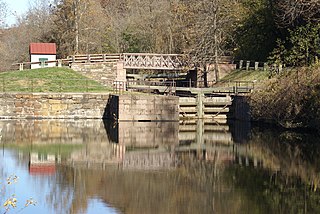
Phoenixville is a borough in Chester County, Pennsylvania, United States, 28 miles (45 km) northwest of Philadelphia, at the junction of French Creek with the Schuylkill River. It is located in the Philadelphia Metro Area. The population is 16,440 as of the 2010 Census. As noted by Forbes, Phoenixville is a former beaten-down mill town with a recent downtown revitalization plan that led to 10 craft breweries and a distillery. Downtown Phoenixville has more breweries per square foot than anywhere else in America.

The Schuylkill River is a river running northwest to southeast in eastern Pennsylvania, which was improved by navigations into the Schuylkill Canal. Several of its tributaries drain major parts of the center-southern and easternmost Coal Regions in the state. It flows for 135 miles (217 km) from Pottsville to Philadelphia, where it joins the Delaware River as one of its largest tributaries.

The Allegheny Portage Railroad was the first railroad constructed through the Allegheny Mountains in central Pennsylvania, United States; it operated from 1834 to 1854 as the first transportation infrastructure through the gaps of the Allegheny that connected the midwest to the eastern seaboard across the barrier range of the Allegheny Front. Approximately 36 miles (58 km) long overall, both ends connected to the Pennsylvania Canal, and the system was primarily used as a portage railway, haulting river boats and barges over the divide between the Ohio and the Susquehanna Rivers. Today, the remains of the railroad are preserved within the Allegheny Portage Railroad National Historic Site operated by the National Park Service.

The Union Canal was a towpath canal that existed in southeastern Pennsylvania in the United States during the 19th century. First proposed in 1690 to connect Philadelphia with the Susquehanna River, it ran approximately 82 mi from Middletown on the Susquehanna below Harrisburg to Reading on the Schuylkill River.

Manayunk is a neighborhood in the section of Lower Northwest Philadelphia in the state of Pennsylvania. Located adjacent to the neighborhoods of Roxborough and Wissahickon and also on the banks of the Schuylkill River, Manayunk contains the first canal begun in the United States. The area's name is derived from the language of the Lenape Indians. In 1686-dated papers between William Penn and the Lenape, the Lenape referred to the Schuylkill River as "Manaiung", their word for "river", which literally translates as "place to drink"; the word was later altered and adopted as the town's name.
The Schuylkill Expressway, locally known as "the Schuylkill", is a two to eight lane freeway through southwestern Montgomery County and the city of Philadelphia, and the easternmost segment of Interstate 76 in the U.S. state of Pennsylvania. It extends from the Valley Forge exit of the Pennsylvania Turnpike in King of Prussia, paralleling its namesake Schuylkill River for most of the route, to the Walt Whitman Bridge in South Philadelphia. It serves as the primary corridor into Philadelphia from points west. Maintenance and planning are administered through Pennsylvania Department of Transportation (PennDOT) District 6. Constructed over a period of ten years from 1949 to 1959, a large portion of the expressway predates the 1956 introduction of Interstate Highway System; many of these portions were not built to contemporary standards. The rugged terrain, limited riverfront space covered by the route and narrow spans of bridges passing over the highway have largely stymied later attempts to upgrade or widen the highway. With the road being highly over capacity, it has become notorious for its chronic congestion. An average of 163,000 vehicles use the road daily in Philadelphia County, and an average of 109,000 use the highway in Montgomery County, making it the busiest road in commonwealth of Pennsylvania. Its narrow lane and left shoulder configuration, left lane entrances and exits, common construction activity and generally congested conditions have led to many accidents, critical injuries and fatalities, leading to the highway's humorous nickname of the "Surekill Expressway" or in further embellishment, the "Surekill Distressway" or the “Surekill Crawlway".
The Schuylkill Valley Metro (SVM) was a proposal for a 62-mile railway system that would link Philadelphia, Pennsylvania with the city of Reading, Pennsylvania in central Berks County, using the SEPTA Manayunk/Norristown Line and Cynwyd Line, plus two Norfolk Southern Railway freight-only lines. The proposal was rejected by the Federal Transit Administration; there are no plans to move forward with the project.

The Schuylkill Canal, or Schuylkill Navigation, was a system of interconnected canals and slack-water pools along the Schuylkill River in the U.S. state of Pennsylvania, built as a commercial waterway in the early 19th-century. Chartered in 1815, the navigation opened in 1825 to provide transportation and water power. At the time, the river was the least expensive and most efficient method of transporting bulk cargo, and the eastern seaboard cities of the U.S. were experiencing an energy crisis due to deforestation. It fostered the mining of anthracite coal as the major source of industry between Pottsville and eastern markets. Along the tow-paths, mules pulled barges of coal from Port Carbon through the water gaps to Pottsville; locally to the port and markets of Philadelphia; and some then by ship or through additional New Jersey waterways, to New York City markets.

The Schuylkill River Trail is a multi-use trail along the banks of the Schuylkill River in southeastern Pennsylvania. Partially complete as of 2018, the trail is ultimately planned to run about 140 miles (230 km) from the river's headwaters in Schuylkill County to Fort Mifflin in Philadelphia.
The Lebanon and Tremont Branch of the Philadelphia & Reading Railroad was a railroad line in Lebanon and Schuylkill County, Pennsylvania, built to tap the coal fields in the West End of Schuylkill County and send coal southward to Lebanon.

The Harrisburg Subdivision is a railroad line owned by CSX Transportation in the U.S. state of Pennsylvania. The line is located in the city of Philadelphia, connecting Greenwich Yard and the Philadelphia Subdivision with the Trenton Subdivision along a former Pennsylvania Railroad line. Much of the Harrisburg Subdivision is the High Line or West Philadelphia Elevated along 31st Street over the 30th Street Station area.

The Harrisburg Line is a rail line owned and operated by the Norfolk Southern Railway (NS) in the U.S. state of Pennsylvania. The line runs from Philadelphia west to Harrisburg.

The Schuylkill Branch was a rail line owned and operated by the former Pennsylvania Railroad in the U.S. state of Pennsylvania. The line ran from the Philadelphia to Harrisburg Main Line at 52nd Street in Philadelphia north via Norristown, Reading, and Pottsville to Delano Junction. From Delano Junction, the PRR had trackage rights over the Lehigh Valley Railroad's Hazleton Branch and Tomhicken Branch to Tomhicken, where the PRR's Catawissa Branch began. In conjunction with the Catawissa Branch, Nescopeck Branch, and Wilkes-Barre Branch, the Schuylkill Branch gave the PRR a direct line from Philadelphia to Wilkes-Barre.

52nd Street is a closed train station that was located at the intersection of North 52nd Street & Landsdowne Avenue in the West Philadelphia section of Philadelphia, Pennsylvania, United States. It was built by the Pennsylvania Railroad (PRR) at the junction of its Main Line and its Schuylkill Branch. Today, these lines are the SEPTA Regional Rail Paoli/Thorndale Line and Cynwyd Line, respectively.

The Falls Bridge is a steel Pratt truss bridge that spans the Schuylkill River in Fairmount Park in Philadelphia, Pennsylvania. It connects Kelly Drive at Calumet Street with Martin Luther King, Jr. Drive at Neill Drive. It replaced a wooden covered bridge at the same site.

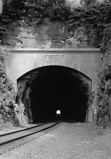
The Black Rock Tunnel is an active rail road tunnel of the old Reading Railroad. The 1835 tunnel was the third rail tunnel constructed in the United States, and is the third oldest still in use. The tunnel is also notable as being the first for which shafts were sunk during construction. The tunnel is cut through a hill in Phoenixville, Pennsylvania, United States. The tunnel and line are now owned by Norfolk Southern as part of its Harrisburg Line.

The Manayunk Bridge is an S-shaped former railroad bridge over the Schuylkill River, Schuylkill Canal and Schuylkill Expressway, that connects Bala Cynwyd, Montgomery County and the Manayunk neighborhood of Philadelphia, Pennsylvania. Closed to rail traffic in 1986, it is now an extension of the Cynwyd Heritage Trail and connects to the Schuylkill River Trail.

The Manayunk/Norristown Line is a commuter rail line in Southeastern Pennsylvania, and one of the 13 lines in SEPTA's Regional Rail network.

The Catawissa Railroad was a railroad that operated in Pennsylvania between 1860 and 1953. For most of its lifespan it was leased by the Reading Company, and was subsequently merged into the Reading.


