Flodday, Loch Maddy

Last updated

Flodday
Scottish Gaelic nameFlodaigh [1]
Old Norse nameFlot-øy
Meaning of name'raft' or 'float' island, from Old Norse [1]
An Glais-eilean Meadhonach - geograph.org.uk - 1510551.jpg
Flodday from the south with the hills east of Loch Portain, North Uist beyond
Location
Outer Hebrides UK relief location map.jpg
Red pog.svg
Flodday
Flodday shown within the Outer Hebrides
OS grid reference NF941696
Coordinates 57°36′47″N7°07′34″W / 57.613°N 7.126°W / 57.613; -7.126
Physical geography
Island group Uists and Barra
Area50 hectares (0.19 sq mi) [2]
Area rank199= [3]
Highest elevation25 m (82 ft) [4]
Administration
Sovereign state United Kingdom
Country Scotland
Council area Na h-Eileanan Siar
Demographics
Population0 [5]
Lymphad3.svg

Flodday (Scottish Gaelic : Flodaigh) is an uninhabited island in Loch Maddy, North Uist in the Outer Hebrides of Scotland.

Contents

The area of the island is recorded as 50 hectares (124 acres) in Rick Livingstone's tables, [2] although it is not listed by Hamish Haswell-Smith in his tabulation of Scottish islands greater in size than 40 hectares (99 acres). [6] No reason for this is given and his area calculation presumably provided a figure smaller than this total.

Loch Maddy contains a bewildering profusion of islands and islets. To the north west lie the smaller island of Fearamas and the complex island of Cliasaigh Mor/Cliasaigh Beag. The entrance to the sea loch is to the south east where lie the waters of The Minch. The village of Lochmaddy is to the west on the far side of the loch. [4] Flodday is separated from North Uist by the narrows of Caolas Loch Portain. [4]

The coastline is described as "lag boulders and gravel intertidal areas" to the north, east and west and rock or rock platform in the south and south east. [7]

Folklore and stories

The Carmichael Watson Project records a brief story concerning a great northern diver. Kenneth MacLean, a local merchant, describes his sighting of this bird, at Flodday in 1884. Although he was familiar with the species it was the sole occasion on which he had seen it in flight. He recorded that "the wings went rapidly and the bird seemed to exert himself greatly". [8] The island is also referred to in the Notebook of Alexander Carmichael, which contains material collected between October 1867 and December 1885. [9]

The freshwater Loch na Beiste lies just beyond Caolas Loch Portain not far from the shore of North Uist. It was reputedly the haunt of a sea-cow. [10]

Citations

  1. 1 2 Mac an Tàilleir, Iain (2003) Ainmean-àite/Placenames. (pdf) Pàrlamaid na h-Alba. Retrieved 26 August 2012.
  2. 1 2 "Rick Livingstone’s Tables of the Islands of Scotland" (pdf) Argyll Yacht Charters. Retrieved 23 September 2013.
  3. Area and population ranks: there are c.300 islands over 20ha in extent and 93 permanently inhabited islands were listed in the 2011 census.
  4. 1 2 3 Ordnance Survey. OS Maps Online (Map). 1:25,000. Leisure.
  5. National Records of Scotland (15 August 2013). "Appendix 2: Population and households on Scotland's Inhabited Islands" (PDF). Statistical Bulletin: 2011 Census: First Results on Population and Household Estimates for Scotland Release 1C (Part Two) (PDF) (Report). SG/2013/126. Retrieved 14 August 2020.
  6. Haswell-Smith (2004) pp. xii, 206, 244
  7. "Coastal Zone Assessment Survey: East Coast of North Uist, Benbecula & South Uist". (pdf) The SCAPE Trust. Retrieved 2 January 2015.
  8. "Story about a great northern diver". Folio 22r, line 14 to folio 22v, line 20. Pròiseact MhicGilleMhìcheil MhicBhatair. Retrieved 2 January 2015.
  9. "Transcription notebook of Alexander Carmichael ". Pròiseact MhicGilleMhìcheil MhicBhatair. Retrieved 2 January 2015.
  10. "Water-horses and Water-bulls". Electric Scotland. Retrieved 2 January 2015.

Related Research Articles

<span class="mw-page-title-main">Ronay</span>

Ronay is an island in the Outer Hebrides of Scotland, which lies a short distance off the east coast of Grimsay.

<span class="mw-page-title-main">Fuday</span>

Fuday is an uninhabited island of about 232 hectares and is one of ten islands in the Sound of Barra, a Site of Community Importance for conservation in the Outer Hebrides of Scotland. It lies just east of Scurrival Point on Barra and west of Eriskay. Fuday is owned by the Scottish Government. Deserted since 1901, its peak population is recorded only as seven.

There are many small islands in Scotland called Flodday or similar and this list provides a guide to their location. The derivation of the name is from the Old Norse floti meaning "raft" or "float". The similar island names Fladda and Flotta are also from the Norse flatr and mean "flat island". Usage is not always consistent in external sources.

Ceann Ear is the largest island in the Monach or Heisgeir group off North Uist in north west Scotland. It is 203 hectares in size and connected by sandbanks to Ceann Iar via Sibhinis at low tide. It is said that it was at one time possible to walk all the way to Baleshare, and on to North Uist, 5 miles away at low tide. In the 16th century, a large tidal wave was said to have washed this away.

Stockinish Island is an uninhabited island off Harris, in the Outer Hebrides.

Stuley is an island lying to the east of South Uist in the Outer Hebrides, Scotland. It lies off the section of coastline between Loch Eynort and Loch Boisdale. It is 45 hectares (0.17 sq mi) and 40 metres (131 ft) at its highest point.

<span class="mw-page-title-main">Nave Island</span>

Nave Island lies to the north of Islay in the Inner Hebrides near the mouth of Loch Gruinart. It is uninhabited.

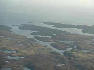
Na h-Eileanan Iasgaich comprise a small uninhabited archipelago in Loch Boisdale, in the south east of the island of South Uist, in the Outer Hebrides, Scotland. The individual islands are separated from one another at high tide, but connected to one another at low tide,. They are around 50 ha in extent and over 20m at their highest point. Their boundaries are ill-defined.

Ceallasaigh Mòr is a low-lying island in Loch Maddy off North Uist in the Outer Hebrides of Scotland. This an area of shallow lagoons filled and drained by the tides each day. Ceallasaigh Beag lies to the south and these two islets are connected by a narrow strip of sand at low tide. Ceallasaigh Mòr may also join mainland North Uist near Bràigh Cheallasaigh at some stages of the tide.

<span class="mw-page-title-main">Lewis and Harris</span> Largest island in Scotland, part of the Outer Hebrides

Lewis and Harris, or Lewis with Harris, is a single Scottish island in the Outer Hebrides, divided by mountains. It is the largest island in Scotland and the third largest in the British Isles, after Great Britain and the island of Ireland, with an area of 841 square miles (2,178 km2), which is approximately 1% of the area of Great Britain. The northern two-thirds is called [the Isle of] Lewis and the southern third [the Isle of] Harris; each is frequently referred to as if it were a separate island.

<span class="mw-page-title-main">Inverness-shire</span> Historic county in Scotland

Inverness-shire is a historic county, registration county and lieutenancy area of Scotland. Covering much of the Highlands and Outer Hebrides, it is Scotland's largest county, though one of the smallest in population, with 67,733 people or 1.34% of the Scottish population.

Stromay is a tidal island off North Uist in the Sound of Harris, Scotland.

<span class="mw-page-title-main">Orosay</span> Tidal Island by Barra, Scotland

Orosay is a small uninhabited tidal island in the Sound of Barra lying at the north end of Traigh Mhòr, the "big beach" on the north east coast of Barra. It is one of ten islands in the Sound of Barra, a Site of Community Importance for conservation in the Outer Hebrides of Scotland. It is about 30 hectares in extent and the highest point is 38 metres (125 ft).

<span class="mw-page-title-main">Fraoch-Eilean</span>

Fraoch-eilean is a small island with an uncertain population north of Benbecula in the Outer Hebrides of Scotland. It is about 55 hectares in extent and the highest point is 11 metres (36 ft). Its name derives from the Gaelic for "heather island".

<span class="mw-page-title-main">Eilean Mhic Chrion</span> Island in Scotland, United Kingdom

Eilean Mhic Chrion is a tidal island sheltering Ardfern in Loch Craignish, Scotland.

<span class="mw-page-title-main">Eileanan Chearabhaigh</span> Tidal islands of Scotland

Eileanan Chearabhaigh is a collection of small uninhabited tidal islands off the south east coast of Benbecula in the Outer Hebrides of Scotland. The English language name Keiravagh Islands is sometimes used.

<span class="mw-page-title-main">Ceallasaigh Beag</span> Island in the Outer Hebrides, Scotland

Ceallasaigh Beag is a low-lying island in Loch Maddy off North Uist in the Outer Hebrides of Scotland. This an area of shallow lagoons filled and drained by the tides each day. Ceallasaigh Mòr lies to the south and these two islets are connected by a narrow strip of sand during some low tides.

<span class="mw-page-title-main">Sursaigh</span> Island off North Uist in the Sound of Harris, Scotland

Sursaigh is an island off North Uist in the Sound of Harris, Scotland. It lies 8 kilometres (5.0 mi) northeast of the village of Lochmaddy and there are numerous nearby islands including Stromay, Sgarabhaigh and Tahay.

References

Haswell-Smith, Hamish (2004). The Scottish Islands. Edinburgh: Canongate. ISBN   978-1-84195-454-7.