Almonaster Avenue is a four-lane divided road in New Orleans, Louisiana, United States, named after 18th-century Spanish philanthropist Don Andres Almonaster y Rojas. It forms in the residential neighborhoods of the Upper Ninth Ward by branching off at a Y-type intersection with Franklin Avenue. Shortly afterwards, the road elevates on an overpass to cross the Norfolk Southern Railway and returns to ground level as it crosses the Industrial Canal on the Almonaster Avenue Bridge, a bascule bridge that it shares with CSX Transportation, proceeding into New Orleans East. The traffic lanes straddle the railroad bridge on either side; this is the only location where Almonaster becomes a two-lane road, albeit divided. It is also the last of the combination railroad/automobile movable bridges. It winds through the New Orleans Business and Industrial District parallel with the Mississippi River Gulf Outlet and Gulf Intracoastal Waterway. It intersects with Interstate 510 before finally ending at the junction with U.S. Highway 90.
The Mississippi River–Gulf Outlet Canal is a 76 mi (122 km) channel constructed by the United States Army Corps of Engineers at the direction of Congress in the mid-20th century that provided a shorter route between the Gulf of Mexico and New Orleans' inner harbor Industrial Canal via the Intracoastal Waterway.

The Ninth Ward or 9th Ward is a distinctive region of New Orleans, Louisiana, which is located in the easternmost downriver portion of the city. It is geographically the largest of the 17 Wards of New Orleans. On the south, the Ninth Ward is bounded by the Mississippi River. On the western or "upriver" side, the Ninth Ward is bounded by Franklin Avenue, then Almonaster Avenue, then People's Avenue. From the north end of People's Avenue the boundary continues on a straight line north to Lake Pontchartrain; this line is the boundary between the Ninth and the city's Eighth Ward. The Lake forms the north and northeastern end of the ward. St. Bernard Parish is the boundary to the southeast, Lake Borgne farther southeast and east, and the end of Orleans Parish to the east at the Rigolets.

The Huey P. Long Bridge, located in Jefferson Parish, Louisiana, is a cantilevered steel through-truss bridge that carries a two-track railroad line over the Mississippi River at mile 106.1, with three lanes of US 90 on each side of the central tracks. It is several kilometers upriver from the city of New Orleans. The East Bank entrance is at Elmwood, Louisiana, and the West Bank at Bridge City.

The Industrial Canal is a 5.5-mile (8.9 km) waterway in New Orleans, Louisiana, United States. The waterway's proper name, as used by the U.S. Army Corps of Engineers and on NOAA nautical charts, is Inner Harbor Navigation Canal (IHNC). The more common "Industrial Canal" name is used locally, both by commercial mariners and by landside residents.

Though Hurricane Katrina did not deal the city of New Orleans a direct hit on August 29, 2005, the associated storm surge precipitated catastrophic failures of the levees and flood walls. The Mississippi River Gulf Outlet ("MR-GO") breached its levees in approximately 15 places. The major levee breaches in the city include the 17th Street Canal levee, the London Avenue Canal, and the wide, navigable Industrial Canal, which left approximately 80% of the city flooded.

The Lower Ninth Ward is a neighborhood in the city of New Orleans, Louisiana. As the name implies, it is part of the 9th Ward of New Orleans. The Lower Ninth Ward is often thought of as the entire area within New Orleans downriver of the Industrial Canal; however, the City Planning Commission divides this area into the Lower Ninth Ward and Holy Cross neighborhoods.

On Monday, August 29, 2005, there were over 50 failures of the levees and flood walls protecting New Orleans, Louisiana, and its suburbs following passage of Hurricane Katrina. The failures caused flooding in 80% of New Orleans and all of St. Bernard Parish. In New Orleans alone, 134,000 housing units—70% of all occupied units—suffered damage from Hurricane Katrina and the subsequent flooding.

ING 4727 was a barge belonging to Ingram Barge Company that became infamous when it went over or through a levee and landed in a residential neighborhood of New Orleans, Louisiana during Hurricane Katrina.

The Inner Harbor Navigation Canal Lock—commonly known as Industrial Canal Lock or simply Industrial Lock—is a navigation lock in New Orleans. It connects the Lower Mississippi River to the Industrial Canal and other sea-level waterways. Because it is shorter and narrower than most modern locks on the Mississippi River System, the 1920s vintage lock has become a bottleneck between the nation's two highest-tonnage waterways—the Mississippi and the Gulf Intracoastal Waterway.
Louisiana Highway 23 is a north–south state highway in Louisiana that serves Plaquemines and Jefferson Parishes. It spans 74.0 miles (119.1 km) in roughly a southeast to northwest direction. It is known locally as Belle Chasse Highway and Lafayette Street.

U.S. Highway 90 (US 90), one of the major east–west U.S. Highways in the Southern United States, runs through southern Louisiana for 297.6 miles (478.9 km), serving Lake Charles, Lafayette, New Iberia, Morgan City, and New Orleans. Much of it west of Lafayette and east of New Orleans has been supplanted by Interstate 10 (I-10) for all but local traffic, but the section between Lafayette and New Orleans runs a good deal south of I-10.

The Claiborne Avenue Bridge, officially known as the Judge William Seeber Bridge, is a vertical lift bridge in New Orleans, Louisiana over the Industrial Canal. It was built by the Louisiana Department of Highways and opened to vehicular traffic in 1957. The bridge has suffered numerous disasters: A barge hit the bridge in 1993, Hurricane Katrina damaged it in 2005, and a car plunged into the canal in 2008 due to a malfunction.
The St. Claude Avenue Bridge is a bascule bridge with four vehicular lanes over the Industrial Canal in New Orleans, Louisiana. The bridge was designed by the Strauss Bascule Bridge Company of Chicago and built in 1919 by the Bethlehem Steel Bridge Corporation. It was originally a combination railroad and automobile bridge, with two pairs of railroad tracks in the center of the lift span and automobile lanes straddling it. The railroad is no longer there, its place on the bridge taken by additional vehicular lanes. One lane in each direction passes through the truss of the bridge and one lane passes alongside the truss. The bridge is integrated into the Industrial Canal Lock structure, on the river side of the lock chamber; it raises when marine traffic enters or exits the lock.

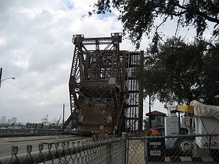
The Almonaster Avenue Bridge is a bascule bridge in New Orleans, Louisiana. The bridge has two vehicular lanes of Almonaster Avenue and two railroad tracks over the Industrial Canal.
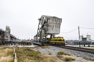
The Seabrook Railroad Bridge is a bascule bridge in New Orleans, Louisiana running adjacent to the Seabrook Bridge. It is often confused with this vehicular bridge to the north, officially called the Senator Ted Hickey Bridge; therefore, it is commonly called the Seabrook Railroad Bridge, that now carries only trains across the canal. The bridge has a horizontal clearance of 79 feet (24 m) with unlimited vertical clearance when fully retracted.

The Inner Harbor Navigation Canal Lake Borgne Surge Barrier is a storm surge barrier constructed near the confluence of and across the Gulf Intracoastal Waterway (GIWW) and the Mississippi River Gulf Outlet (MRGO) near New Orleans. The barrier runs generally north-south from a point just east of Michoud Canal on the north bank of the GIWW and just south of the existing Bayou Bienvenue flood control structure.

The Inner Harbor Navigation Canal (IHNC) Seabrook Floodgate Structure is a flood barrier in the Industrial Canal in New Orleans, Louisiana. The floodgate is designed to protect the Industrial Canal and the surrounding areas from a storm surge from Lake Pontchartrain. It consists of two 50-foot (15 m) wide vertical lift gates and a 95-foot (29 m) wide sector gate.

There are three outfall canals in New Orleans, Louisiana – the 17th Street, Orleans Avenue and London Avenue canals. These canals are a critical element of New Orleans’ flood control system, serving as drainage conduits for much of the city. There are 13 miles (21 km) of levees and floodwalls that line the sides of the canals. The 17th Street Canal is the largest and most important drainage canal and is capable of conveying more water than the Orleans Avenue and London Avenue Canals combined.

