
Streetcars have been an integral part of the public transportation network of New Orleans since the first half of the 19th century. The longest of the city's streetcar lines, the St. Charles Avenue line, is the oldest continuously operating street railway system in the world. Today, the streetcars are operated by the New Orleans Regional Transit Authority (RTA).
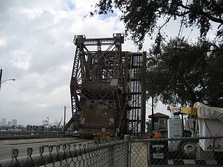
Almonaster Avenue is a four-lane divided road in New Orleans, Louisiana, United States, named after 18th-century Spanish philanthropist Don Andres Almonaster y Rojas. It forms in the residential neighborhoods of the Upper Ninth Ward by branching off at a Y-type intersection with Franklin Avenue. Shortly afterwards, the road elevates on an overpass to cross the Norfolk Southern Railway and returns to ground level as it crosses the Industrial Canal on the Almonaster Avenue Bridge, a bascule bridge that it shares with CSX Transportation, proceeding into New Orleans East. The traffic lanes straddle the railroad bridge on either side; this is the only location where Almonaster becomes a two-lane road, albeit divided. It is also the last of the combination railroad/automobile movable bridges. It winds through the New Orleans Business and Industrial District parallel with the Mississippi River Gulf Outlet and Gulf Intracoastal Waterway. It intersects with Interstate 510 before finally ending at the junction with U.S. Highway 90.

The Ninth Ward or 9th Ward is a distinctive region of New Orleans, Louisiana, which is located in the easternmost downriver portion of the city. It is geographically the largest of the 17 Wards of New Orleans. On the south, the Ninth Ward is bounded by the Mississippi River. On the western or "upriver" side, the Ninth Ward is bounded by Franklin Avenue, then Almonaster Avenue, then People's Avenue. From the north end of People's Avenue the boundary continues on a straight line north to Lake Pontchartrain; this line is the boundary between the Ninth and the city's Eighth Ward. The Lake forms the north and northeastern end of the ward. St. Bernard Parish is the boundary to the southeast, Lake Borgne farther southeast and east, and the end of Orleans Parish to the east at the Rigolets.

The Huey P. Long Bridge, located in Jefferson Parish, Louisiana, is a cantilevered steel through-truss bridge that carries a two-track railroad line over the Mississippi River at mile 106.1, with three lanes of US 90 on each side of the central tracks. It is several kilometers upriver from the city of New Orleans. The East Bank entrance is at Elmwood, Louisiana, and the West Bank at Bridge City.

The Industrial Canal is a 5.5-mile (8.9 km) waterway in New Orleans, Louisiana, United States. The waterway's proper name, as used by the U.S. Army Corps of Engineers and on NOAA nautical charts, is Inner Harbor Navigation Canal (IHNC). The more common "Industrial Canal" name is used locally, both by commercial mariners and by landside residents.

The Florida Avenue Bridge is a vertical lift bridge spanning the Industrial Canal in New Orleans, Louisiana. The bridge has one railroad track, two vehicle lanes and two sidewalks. A parallel high-elevation four-lane roadway bridge is planned.

The 8th Ward is a section of New Orleans, Louisiana. It is one of the Downtown Wards of New Orleans, with a Creole history.

Gentilly is a broad, predominantly middle-class and racially diverse section of New Orleans, Louisiana. The Gentilly neighborhood is bounded by Lake Pontchartrain to the north, France Road to the east, Bayou St. John to the west, and CSX Transportation railroad tracks to the south.

Elysian Fields Avenue is a broad, straight avenue in New Orleans named after the Avenue des Champs-Élysées in Paris. It courses south to north from the Lower Mississippi River to Lake Pontchartrain, a distance of approximately 5 miles (8.0 km). The avenue intersects with Interstate 610, Interstate 10, and U.S. Highway 90, Gentilly Boulevard passing by Brother Martin High School. The part between North Claiborne Avenue and Gentilly Boulevard is Louisiana Highway 3021 ; the piece from N. Claiborne Avenue south to St. Claude Avenue carries Louisiana Highway 46.

U.S. Highway 90 Business is a business route of U.S. Highway 90 located in and near New Orleans, Louisiana. It runs 14.25 miles (22.93 km) in a general east–west direction from US 90 in Avondale to a junction with Interstate 10 (I-10) and US 90 in the New Orleans Central Business District.
U.S. Highway 90 (US 90), one of the major east–west U.S. Highways in the Southern United States, runs through southern Louisiana for 297.6 miles (478.9 km), serving Lake Charles, Lafayette, New Iberia, Morgan City, and New Orleans. Much of it west of Lafayette and east of New Orleans has been supplanted by Interstate 10 (I-10) for all but local traffic, but the section between Lafayette and New Orleans runs a good deal south of I-10.

The Claiborne Avenue Bridge, officially known as the Judge William Seeber Bridge, is a vertical lift bridge in New Orleans, Louisiana over the Industrial Canal. It was built by the Louisiana Department of Highways and opened to vehicular traffic in 1957. The bridge has suffered numerous disasters: A barge hit the bridge in 1993, Hurricane Katrina damaged it in 2005, and a car plunged into the canal in 2008 due to a malfunction.

Louisiana Highway 47 (LA 47) is a state highway located in southeastern Louisiana. It runs 15.91 miles (25.60 km) in a general southeast to northwest direction from the Mississippi River levee in Chalmette to the intersection of Hayne Boulevard and Downman Road in New Orleans.
The St. Claude Avenue Bridge is a bascule bridge with four vehicular lanes over the Industrial Canal in New Orleans, Louisiana. The bridge was designed by the Strauss Bascule Bridge Company of Chicago and built in 1919 by the Bethlehem Steel Bridge Corporation. It was originally a combination railroad and automobile bridge, with two pairs of railroad tracks in the center of the lift span and automobile lanes straddling it. The railroad is no longer there, its place on the bridge taken by additional vehicular lanes. One lane in each direction passes through the truss of the bridge and one lane passes alongside the truss. The bridge is integrated into the Industrial Canal Lock structure, on the river side of the lock chamber; it raises when marine traffic enters or exits the lock.
The Danziger Bridge is a vertical lift bridge that carries seven vehicular lanes of U.S. Route 90 across the Industrial Canal in New Orleans, Louisiana. Built to replace the old Danziger Bridge, a draw bridge constructed in 1931–1932, the current Danziger Bridge was constructed on the south side of the old bridge between 1983 and 1987 and officially opened in February 1988. Named after a New Orleans lawyer and businessman, it became the widest lift bridge in the world. Most marine traffic is accommodated in the down position.
The Seabrook Railroad Bridge is a bascule bridge in New Orleans, Louisiana running adjacent to the Seabrook Bridge. It is often confused with this vehicular bridge to the north, officially called the Senator Ted Hickey Bridge; therefore, it is commonly called the Seabrook Railroad Bridge, that now carries only trains across the canal. The bridge has a horizontal clearance of 79 feet (24 m) with unlimited vertical clearance when fully retracted.

U.S. Highway 11 (US 11) is a part of the United States Numbered Highway System that spans 1,645 miles (2,647 km) from New Orleans, Louisiana, to Rouses Point, New York. Within the state of Louisiana, the highway travels 31 miles (50 km) from the national southern terminus at US 90 in New Orleans to the Mississippi state line south of Picayune.

Louisiana Highway 3082 was a state highway in Louisiana that served Orleans and St. Bernard Parishes. It spanned 6.2 miles (10.0 km) in a west–east direction along the present route of LA 39 between New Orleans and Chalmette. It was essentially a temporary designation for the relocation of LA 39 north (west) of LA 47.

Louisiana Highway 613 was a collection of four state-maintained streets in Metairie and New Orleans established with the 1955 Louisiana Highway renumbering. All four routes have since been deleted from the state highway system.


