
Snowdonia, or Eryri, is a mountainous region and national park in North Wales. It contains all 15 mountains in Wales over 3000 feet high, including the country's highest, Snowdon, which is 1,085 metres (3,560 ft) tall. These peaks are all part of the Snowdon, Glyderau, and Carneddau ranges in the north of the region. The shorter Moelwynion and Moel Hebog ranges lie immediately to the south.

Arenig Fawr is a mountain in Snowdonia, North Wales, close to Llyn Celyn reservoir, alongside the A4212 between Trawsfynydd and Bala.

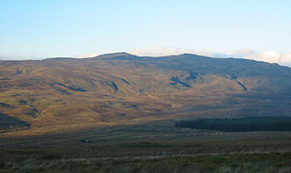
Arenigs is an informal term for a group of mountains in central Snowdonia, in north Wales. They are not strictly defined, but normally include at least the following peaks:

Rhobell Fawr is the site of an ancient volcano that was active during the Early Ordovician period in the Arenig range within the Snowdonia National Park.

Llyn Arenig Fawr is a lake and reservoir located near the summit of Arenig Fawr, a mountain in North Wales.

The Migneint is a large expanse of moorland in central Snowdonia, north-west Wales. It is part of the Migneint-Arenig-Dduallt Special Area of Conservation, along with the mountains Arenig Fawr, Arenig Fach and Dduallt, covering a range of nearly 200 square kilometres (77 sq mi). It is either the largest area of blanket bog in Wales, or the second largest, after the Berwyn range, further to the east.
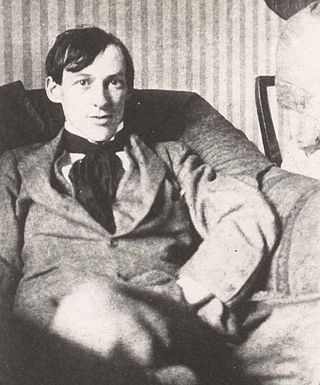
James Dickson Innes was a Welsh painter, mainly of mountain landscapes but occasionally of figure subjects. He worked in both oils and watercolours.

Carnedd y Filiast is a mountain near Cerrigydrudion on the border of the Snowdonia National Park, North Wales and is 669 metres (2,195 ft) high.

Arenig Fach is a mountain in southern Snowdonia, north Wales. It is a peak in the Arenig range and lies to the north of its parent peak Arenig Fawr.

Moel Llyfnant is a mountain in the southern portion of the Snowdonia National Park in Gwynedd, Wales. It is a peak in the Arenig mountain range. It lies to the west of Arenig Fawr. It has one notable top, the twin peaked Gallt y Daren, being at the end of its west ridge.
Gallt y Daren is a peak in the southern half of the Snowdonia National Park in Gwynedd, North Wales, and forms part of the Arenig mountain range. It is a top of Moel Llyfnant, and is twin peaked. It lies to the west of Moel Llyfnant.

Carnedd Llechwedd-llyfn is a subsidiary summit of Carnedd y Filiast on the border of Snowdonia National Park in Llandderfel, in Gwynedd. The northern slopes of the peak lie in Ysbyty Ifan, in Conwy. It is part of the Arenig mountain range, and rises from the shore of Llyn Celyn.

Waun Garnedd-y-filiast is a top of Carnedd y Filiast on the border of the Snowdonia National park near Cerrigydrudion in North Wales. It is part of the Arenig mountain range. It is also a peak in an area of moorland known as the Migneint.

Arenig Fawr South Top is the twin top of Arenig Fawr in southern Snowdonia, North Wales. It is the second highest member of the Arenig range, being 18 m less than its twin. From here the south ridge continues into an area of rocky knolls and small tarns, where Arenig Fawr South Ridge Top can be found.

Arenig Fawr South Ridge Top is a top of Arenig Fawr in southern Snowdonia, North Wales. It lies in area of rocky knolls and small tarns, found on the broad south ridge of Arenig Fawr.

Y Gamallt is a mountain located in the Migneint in Snowdonia, North Wales. It forms part of the Arenig mountain range being separated from the Moelwynion range at the head of Cwm Teigl.

Trinodus is a very small to small blind trilobite, a well known group of extinct marine arthropods, which lived during the Ordovician, in what are now the Yukon Territories, Virginia, Italy, Czech Republic, Poland, Denmark, Sweden, Svalbard, Ireland, Scotland, Wales, Iran, Kazakhstan and China. It is one of the last of the Agnostida order to survive.
Moel y Gydros is a hill located just outside the Snowdonia National Park on the Gwynedd / Conwy border in North Wales. The B4501, Frongoch to Cerrigydrudion road skirts the hills lower slopes.

Cadair Ifan Goch is a crag located above the Conwy Valley in North Wales in the community of Llanddoged and Maenan, and owned by the National Trust. The views extend across the whole of the valley to the Carneddau mountains, and even as far south as the Arenig mountains. The summit of the hill, a bit further up from the crag, reaches 207 metres (679 ft) above sea level.

Rhyd-uchaf is a hamlet in Gwynedd, Wales, approximately 2.4 miles (3.9 km) northwest of Bala and 1.4 miles (2.3 km) south of Frongoch, on an unnamed road which provides access to Arenig Fawr. The community population taken at the 2011 census was 78.
