
The Glyderau are a mountain group in Snowdonia, North Wales. The name derives from the highest peaks in the range, Glyder Fawr and Glyder Fach. According to Sir Ifor Williams, the word "Glyder" derives from the Welsh word "Cludair", meaning a heap of stones.

Glyder Fawr is a mountain in Snowdonia, Wales, the highest peak in the Glyderau range at just over 1,000 metres. It is the fifth-highest mountain in Wales and has several walking and scrambling routes leading to its summit. According to Sir Ifor Williams, the word "Glyder" derives from the Welsh word "Gludair", meaning a heap of stones.
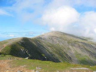
Carnedd Dafydd is a mountain peak in the Carneddau range in Snowdonia, Wales, and is the third highest peak in Wales, or the fourth if Crib y Ddysgl on the Snowdon ridge is counted. Situated south-west of Carnedd Llewelyn and north of Pen yr Ole Wen, Carnedd Dafydd is on the main ridge of the Carneddau, and on the border between Gwynedd and Conwy. The average annual temperature of the mountain is around 3–4 °C (38–40 °F).

Arenig Fawr is a mountain in Snowdonia, North Wales, close to Llyn Celyn reservoir, alongside the A4212 between Trawsfynydd and Bala.

Foel-fras (944 m) is a mountain in the Carneddau range, about 10 km east of Bethesda in North Wales. It lies on the border between the counties of Gwynedd and Conwy. With a summit elevation of 944 m it is officially the eleventh-highest summit in Wales. Foel-fras is located at the northern end of the main ridge of the Carneddau, between Drum to the north and Foel Grach to the south, with the subsidiary summit of Garnedd Uchaf (925 m) between it and Foel Grach. Due south and 400 m below lies the reservoir of Llyn Dulyn, while the smaller reservoir of Llyn Anafon lies to the north.

Rhinog Fawr is a mountain in Snowdonia, North Wales and forms part of the Rhinogydd range. It is the third highest summit of the Rhinogydd, losing out to Y Llethr and Diffwys respectively. Its smaller cousin Rhinog Fach lies to the south, separated by the pass of Bwlch Drws Ardudwy, while its other neighbour, Moel Ysgyfarnogod lies to the north.

Fan Brycheiniog is the highest peak at a height of 802.5 metres (2,633 ft) in the Black Mountain region of the Brecon Beacons National Park in southern Wales. There is a trig point at the peak and on the edge of the escarpment, and nearby, a stone shelter with an inner seat. It lies just inside the historic county of Brecknockshire which gives the mountain its Welsh name. A subsidiary top, less than a kilometre from the summit along the ridge to the northwest, is the highest point of the neighbouring county of Carmarthenshire. Fan Brycheiniog is also within the Fforest Fawr Geopark designated in 2005 in recognition of the area's geological heritage. The views of the moorland and open country to the north are spectacular when the weather is clear, and reveals the isolation of the range, especially when compared with the more popular Pen y Fan range to the east.
The Black Mountain is a mountain range in South, Mid and West Wales, straddling the administrative boundary between Carmarthenshire and Powys and forming the westernmost range of the Brecon Beacons National Park. Its highest point is Fan Brycheiniog at 802 metres or 2,631 ft. The Black Mountain also forms a part of the Fforest Fawr Geopark.

Pumlumon Fach is a top of Pen Pumlumon Fawr on the Plynlimon massif, a part of the Cambrian Mountains in the county of Ceredigion, Wales. It lies on small ridge heading north-west from the summit of Pen Pumlumon Fawr.

Corn Du is a summit of the twin topped Pen y Fan and the second highest peak in South Wales at 871.5 m (2,864 ft), situated in the Brecon Beacons National Park. The summit itself is marked by a well structured Bronze Age cairn with a central burial cist like that on nearby Pen y Fan. The two summits are visible from great distances owing to their height above the surrounding moorland, and are famous landmarks. The views from the peaks are also panoramic and very extensive, the Black Mountain and Fforest Fawr being especially obvious to the west. Mynydd Epynt is visible to the north behind the county town of Brecon, and other parts of the escarpment to the east.

Aran Benllyn is a subsidiary summit of Aran Fawddwy in southern Snowdonia, North Wales, Wales, United Kingdom. It is the second highest peak in the Aran mountain range.

Carnedd y Filiast is a mountain near Cerrigydrudion on the border of the Snowdonia National Park, North Wales and is 669 metres (2,195 ft) high.

Moel Llyfnant is a mountain in the southern portion of the Snowdonia National Park in Gwynedd, Wales. It is a peak in the Arenig mountain range. It lies to the west of Arenig Fawr. It has one notable top, the twin peaked Gallt y Daren, being at the end of its west ridge.

Foel Goch is a mountain in north-east Wales, and forms part of the Arenig mountain range. It is the only member of the Arenig group that lies outside of the Snowdonia National Park.

Carnedd Llechwedd-llyfn is a subsidiary summit of Carnedd y Filiast on the border of Snowdonia National Park in Llandderfel, in Gwynedd. The northern slopes of the peak lie in Ysbyty Ifan, in Conwy. It is part of the Arenig mountain range, and rises from the shore of Llyn Celyn.

Picws Du is the second highest peak of the Carmarthen Fans in the Carmarthenshire section of the Black Mountain in the west of the Brecon Beacons National Park in south Wales. The highest peak is Fan Foel immediately next along the ridge and it is a subsidiary summit of Fan Brycheiniog. Picws Du falls within Fforest Fawr Geopark and its prominent summit is marked by a large Bronze Age round barrow at a height of 2457 feet above sea level. Waun Lefrith is the other, lower summit of the Bannau Sir Gâr / Carmarthen Fans situated to the west. The peak overlooks the glacial lake of Llyn y Fan Fach in the cwm below. As the peak sits on the edge of the escarpment on a ridge which juts out into the valley below, the views from the summit are panoramic and extensive. The views to the north are especially impressive when the weather is clear, looking towards the Cambrian Mountains, Mynydd Epynt and Brecon. Swansea and the Bristol Channel can just be seen on the horizon to the south, across the gently falling dip slope. Pen y Fan and Corn Du are distinctive landmarks seen directly to the east across Fforest Fawr.

Y Gamallt is a mountain located in the Migneint in Snowdonia, North Wales. It forms part of the Arenig mountain range being separated from the Moelwynion range at the head of Cwm Teigl.

Moel Emoel is a hill within the Snowdonia National Park in Gwynedd, North Wales.
Moel y Gydros is a hill located just outside the Snowdonia National Park on the Gwynedd / Conwy border in North Wales. The B4501, Frongoch to Cerrigydrudion road skirts the hills lower slopes.

Moel y Garnedd is a hill within the Snowdonia National Park in Gwynedd, North Wales.

