Foley Charles Prendergast Vereker

Last updated

Foley Charles Prendergast Vereker (21 June 1850 - 24 October 1900) was a Royal Navy Officer and hydrographic surveyor. He is particularly noted as an artist who produced navigational views and illustrations of the places he worked.

HMS Nassau with Mount Burney in the background. From Cunningham (1871) Vereker Mount Burney from the Otter Isles Cunningham 1871 Notesonnaturalhi00cunn 0008.jpg
HMS Nassau with Mount Burney in the background. From Cunningham (1871)

Vereker was born at Whitehall, London, the second son of the fourth Viscount Gort, and attended Burney's Academy, a Naval preparatory school in Gosport, Hampshire. He entered the Royal Navy in 1863, and joined the surveying branch in 1868 as a midshipman on HMS Nassau, surveying in the Strait of Magellan. [2] His illustration of Nassau in the Strait was used as the frontispiece of the published account of the natural history of the voyage. [1]

Vereker's illustration of the 1871 Camiguin eruption, from the Illustrated London News Camiguin Eruption ILN 1871.jpg
Vereker's illustration of the 1871 Camiguin eruption, from the Illustrated London News

Vereker was promoted to sub-lieutenant in 1870, and moved with Nassau to the China Station, where he worked on the survey of the Sulu Archipelago. In the following year he observed a volcanic eruption on the island of Camiguin in the Philippines, and made an illustration of the event. In 1872 he was in charge of a boat at the destruction of the pirate haunt of Carang-Carang. [2] In 1873 he was promoted to Lieutenant, and was employed surveying on the east coast of Africa, still with Nassau. [3] :159–160 [4] :337–340 In 1875 he took part in the bombardment of Mombasa in support of the Sultan of Zanzibar against a rebel chief. [5] In 1876 he married Ellen melia Wilshere. [6] He returned to work in the Magellan Strait in HMS Alert, and in 1879 joined the Royal Yacht Victoria and Albert . He was promoted to Commander in 1881. [2]

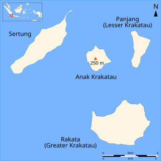
Vereker returned to surveying in 1883, taking command of his first ship, HMS Magpie for work on the China Station. On the 27th August of that year, working off the coast of Borneo,they heard sounds like distant gunfire. The sun, when low, showed a greenish hue. They were later informed of the eruption of Krakatoa a thousand miles away and ordered to the Sunda Strait. [4] :345–347 In October they entered the Strait, and Vereker published an illustrated account of his observations on the aftermath of the eruption. [7]

Vereker 1883 Sunda Strait Plate 2.jpg

Views of Krakatoa after the eruptions of 1883. From Vereker (1883) [7]

Admiralty Chart of Diego Garcia, surveyed by Vereker in 1885 Admiralty Chart No 920 Diego Garcia, from Entrance to East Point, Published 1886.jpg
Admiralty Chart of Diego Garcia, surveyed by Vereker in 1885

In 1884, Vereker commissioned HMS Rambler and the following January set off from Plymouth on what Day has described as a "formidabke years's cruise". Work was carried out in Malta, Trinkitat (Port Mornington) on the Red Sea coast of Sudan, Diego Garcia in the Indian Ocean, where a detailed survey was carried out, and Singapore, arriving in Hong Kong in June. A continuous chain of meridian distances was run from Plymouth to Hong Kong. They then surveyed Haitan Island in the Taiwan Strait. [3] :148

From 1887 to 1889, Vereker was in command of HMS Myrmidon surveying north-west Australia. [8] [9] He was promoted to captain in 1888. [2] He commanded HMS Research in home waters from 1891 to 1895. The surveying work included a re-sounding of the approaches to Portsmouth. He was next employed in preparing sketches of the coasts of Britain and Ireland on HMS Seahorse. In July 1897, Vereker became Adviser to the Harbour Department at the Board of Trade. [3] :159–160 In 1898 he was elected an associate of the Institution of Civil Engineers. He died in 1900 at his home in Isleworth. [2] He was survived by his wife Ellen. [10]

Related Research Articles

<span class="mw-page-title-main">Krakatoa</span> Volcanic caldera in the Sunda Strait

Krakatoa, also transcribed Krakatau, is a caldera in the Sunda Strait between the islands of Java and Sumatra in the Indonesian province of Lampung. The caldera is part of a volcanic island group comprising four islands. Two, Lang and Verlaten, are remnants of a previous volcanic edifice destroyed in eruptions long before the infamous 1883 eruption; another, Rakata, is the remnant of a much larger island destroyed in the 1883 eruption.

<span class="mw-page-title-main">Sunda Strait</span> Strait between the Indonesian islands of Java and Sumatra

The Sunda Strait is the strait between the Indonesian islands of Java and Sumatra. It connects the Java Sea with the Indian Ocean.

<span class="mw-page-title-main">Phillip Parker King</span> Australian explorer and politician (1791–1856)

Rear Admiral Phillip Parker King, FRS, RN was an early explorer of the Australian and Patagonian coasts.

<span class="mw-page-title-main">Rakata</span> Volcano island in the Krakatoa caldera

Rakata, also called Greater Krakatau, is a partially collapsed and uninhabited stratovolcano on the Indonesian island of Krakatoa in the Sunda Strait between the islands of Sumatra and Java. Standing 813 m (2,667 ft) tall, it was the largest and southernmost of three volcanoes that formed the island Krakatoa and the only one not totally destroyed in the 1883 eruption. Rakata is the last remnant of the original island prior to its destruction. However, Rakata did lose its northern half in that eruption, leaving just its southern half. The exposed cliff is quite striking visually, partially of a large exposed dike terminating in a large lenticular extrusion at the middle of the almost vertical cliff. The feature has been called "the Eye of Krakatoa."

<span class="mw-page-title-main">Anak Krakatoa</span> Volcanic island in the Sunda Strait

Anak Krakatoa is a volcanic island in Indonesia. On 29 December 1927, Anak Krakatoa first emerged from the caldera formed in 1883 by the explosive volcanic eruption that destroyed the island of Krakatoa. There has been sporadic eruptive activity at the site since the late 20th century, culminating with a large underwater collapse of the volcano that caused a deadly tsunami in December 2018. There has been subsequent activity since. Due to its young age, the island is one of several in the area that are of interest to, and the subject of extensive study by, volcanologists.

<i>Krakatoa, East of Java</i> 1968 film

Krakatoa, East of Java is a 1968 American disaster film starring Maximilian Schell and Brian Keith. During the 1970s, the film was re-released under the title Volcano. The story is loosely based on events surrounding the 1883 eruption of the volcano on the island of Krakatoa, with the characters engaged in the recovery of a cargo of pearls from a shipwreck perilously close to the volcano. The film was nominated for the Academy Award for Best Special Visual Effects.

<i>Krakatoa: The Last Days</i> 2006 British TV docudrama film directed by Sam Miller

Krakatoa: The Last Days is a BBC Television docudrama that premiered on 7 May 2006 on BBC One. The program is based upon four eyewitness accounts of the 1883 eruption of Krakatoa, an active stratovolcano between the islands of Sumatra and Java, present day Indonesia.

Perboewatan was one of the three main volcanic cones on the island of Krakatoa, in the Sunda Strait, in Indonesia. It was the lowest and northernmost of the cones. Perboewatan was completely destroyed during the 1883 eruption; the caldera is approximately 820 feet (250 m) deep at its former location.

Danan was one of the three volcanic cones on the island of Krakatoa, in the Sunda Strait, in Indonesia. It stood 450 metres (1,480 ft), lay in the central area of the island, and may have been a twin volcano. Danan was almost entirely destroyed in the 1883 eruption of Krakatoa; only a rocky islet named Bootsmansrots remains of it.

Gouverneur Generaal Loudon was a mail steamer and excursion vessel which survived the 1883 eruption of Krakatoa.

<span class="mw-page-title-main">Richard Mayne (explorer)</span>

Rear-Admiral Richard Charles Mayne was a Royal Navy officer and explorer, who in later life became a Conservative politician.

Krakatoa, in the Sunda Strait in Indonesia, has attracted a significant literature and media response to the 1883 eruption and subsequent events in the vicinity.

<span class="mw-page-title-main">1883 eruption of Krakatoa</span> Catastrophic volcanic eruption

The 1883 eruption of Krakatoa in the Sunda Strait occurred from 20 May until 21 October 1883, peaking in the late morning hours of 27 August when over 70% of the island of Krakatoa and its surrounding archipelago were destroyed as it collapsed into a caldera.

<span class="mw-page-title-main">William Wharton (Royal Navy officer)</span> British admiral and Hydrographer of the Navy

Admiral Sir William James Lloyd Wharton was a British admiral and Hydrographer of the Navy.

HMS <i>Myrmidon</i> (1867) Gunvessel of the Royal Navy

HMS Myrmidon was a Cormorant-class gunvessel of the Royal Navy, built at Chatham Dockyard and launched in 1867. She served on the North America and West Indies Station and surveyed parts of the Australian coast before being sold at Hong Kong in 1889.

Thomas Graves was an officer of the Royal Navy and naturalist who worked extensively as a surveyor in the Mediterranean.

<span class="mw-page-title-main">Hydrographic Survey Bench Mark, East Trinity</span> Historic site in Queensland, Australia

Hydrographic Survey Bench Mark is a heritage-listed survey marker at Bessie Point, off Pine Creek-Yarrabah Road, East Trinity, Cairns Region, Queensland, Australia. It was designed by Royal Navy and built in 1878 by Royal Navy. It is also known as Bessie Point. It was added to the Queensland Heritage Register on 9 May 2014.

Admiral Byron Drury (1815–1888) was a British naval officer.

<span class="mw-page-title-main">Arthur Mostyn Field</span>

Admiral Sir Arthur Mostyn Field, was a senior officer in the Royal Navy who served as Hydrographer of the Navy from 1904 to 1909.

<span class="mw-page-title-main">Herbert Purey-Cust</span>

Sir Herbert Edward Purey-Cust, KBE, CB was an officer in the Royal Navy and Hydrographer of the Navy from 1909 to 1914.

References

  1. 1 2 Cunningham, Robert O. (1871). Notes on the Natural History of the Strait of Magellan and West Coast of Patagonia Made During the Voyage of H.M.S. Nassau in the Years 1866, 67, 68, & 69. Edinburgh: Edmonston and Douglas.
  2. 1 2 3 4 5 "OBITUARY. THE HON. FOLEY CHARLES PRENDERGAST VEREKER, CAPTAIN RN, 1850-1900". Minutes of the Proceedings of the Institution of Civil Engineers. 143: 342–343. 1901. doi: 10.1680/imotp.1901.18905 .
  3. 1 2 3 Day, Archibald (1967). The Admiralty Hydrographic Service, 1795-1919. H.M. Stationery Office. OCLC   1082894797.
  4. 1 2 Ritchie, G.S. (1967). The Admiralty Chart. London: Hollis & Carter.
  5. "NAVAL ENGAGEMENT NEAR ZANZIBAR". The Argus (Melbourne) . No. 9, 040. Victoria, Australia. 5 June 1875. p. 10. Retrieved 28 February 2023 via National Library of Australia.
  6. "Foley Charles Prendergast Vereker R.N." The Victorian Royal Navy. Retrieved 28 February 2023.
  7. 1 2 Vereker, F.C.P. (1883). "Extracts from a Report on the Volcanic Eruption in Sunda Strait". Proceedings of the Royal Society of London. 36: 198–199. JSTOR   114436.
  8. Vereker, Foley C. P., "4 p. ; 34 cm.", Report by Captain the Honorable Foley C. P. Vereker of the work carried out by H. M. Surveying vessel "Myrmidon" at Cambridge Gulf during the season of 1888., Perth, nla.obj-2618608071, retrieved 28 February 2023 via Trove
  9. Ingram, Terry. "Library wins fight for journal of ship with exotic battle history". The Australian Art Sales Digest. John Furphy Pty. Ltd., Melbourne, Australia. Retrieved 28 February 2023.
  10. Vereker, Foley C; Vereker, Ellen (1888), Journal of Captain Foley Vereker, 1888-1889 , retrieved 28 February 2023