
James City County is a county located in the Commonwealth of Virginia. As of the 2010 census, the population was 67,009. Although politically separate from the county, the county seat is the adjacent independent city of Williamsburg.

Christiansburg is a town in Montgomery County, Virginia, United States. The population was 21,041 at the 2010 census. It is the county seat of Montgomery County. Christiansburg, Blacksburg and the city of Radford are the three principal municipalities of the Blacksburg–Christiansburg Metropolitan Statistical Area, which encompasses those municipalities, all of Montgomery County, and three other counties.

Orange is a town in, and county seat of, Orange County, Virginia. The population was 4,721 at the 2010 census, representing a 14.5% increase since the 2000 census. Orange is 28 miles (45 km) northeast of Charlottesville, 88 miles (142 km) southwest of Washington, D.C., and 4 miles (6 km) east of James Madison's plantation of Montpelier.

The town of Washington, Virginia, is an historic village located in the eastern foothills of the Blue Ridge Mountains near Shenandoah National Park. It was established as a town by an act of the Virginia General Assembly in 1796 and as the county seat of Rappahannock County, Virginia, in 1833. The town was incorporated in 1894 and was rechartered by the Virginia General Assembly in 1985. A large portion of the town was designated as the Washington Historic District on the Virginia Landmarks Register and the National Register of Historic Places in 1975 and is considered to be the best preserved of county-seat communities in the Piedmont. The town is led by a 7-member elected Town Council composed of a mayor, a treasurer, and five other members, all of whom serve 4-year terms. The internationally recognized Inn at Little Washington is located in the town. The town combines a mixture of open spaces, residences, village commerce, tourism facilities, historic buildings, cultural offerings, and local government activities. Its population was 135 people in the 2010 census and was estimated to be 125 people in 2018. The area of the town is 182 acres (74 ha).

Fort Ashby is a census-designated place (CDP) in Mineral County, West Virginia, USA, along Patterson Creek. It is part of the Cumberland, MD-WV Metropolitan Statistical Area. The population was 1,380 at the 2010 census. The community was originally chartered as Frankfort and then known as Alaska before it took the name of its well-known historic landmark.

Union is a town in Monroe County, West Virginia. The population was 565 at the 2010 census. It is the county seat of Monroe County.

The North Carolina General Assembly of 1777 met in two sessions in New Bern, North Carolina, from April 7 to May 9, 1777, and from November 15 to December 24, 1777. This was the first North Carolina legislature elected after the last provincial congress wrote the first North Carolina Constitution. This assembly elected Richard Caswell as the state's first constitutional governor.

Warwick County was a county in Southeast Virginia that was created from Warwick River Shire, one of eight created in the Virginia Colony in 1634. It became the City of Warwick on July 16, 1952. Located on the Virginia Peninsula on the northern bank of the James River between Hampton Roads and Jamestown, the area consisted primarily of farms and small unincorporated villages until the arrival of the Peninsula Extension of the Chesapeake and Ohio Railway in 1881 and development led by industrialist Collis P. Huntington.
Thomas Lewis was an Irish-American surveyor, lawyer, and a pioneer of early Virginia. He was a signatory to the Fairfax Resolves preceding the American War for Independence, and after the conflict, contributed to the settlement of western Virginia in an area that would one day become part of West Virginia.
George Hamilton was a Canadian merchant and politician, who founded the city of Hamilton, Ontario.

Sweet Springs is an unincorporated community in Monroe County in the U.S. state of West Virginia. Sweet Springs lies at the intersection of West Virginia Route 3 and West Virginia Route 311.
John West was acting colonial Governor of Virginia from 1635 to 1637, the third West brother to serve as Governor.

Pence Springs is an unincorporated community in Summers County, West Virginia, United States. It lies along the Greenbrier River to the east of the city of Hinton, the county seat of Summers County. Its elevation is 1,539 feet, and it is located at 37°40′41″N80°43′30″W. Although it is unincorporated, it had a post office, with the ZIP code of 24962 until it was closed in October 2011.
Sweet Springs Resort and spa was founded in Sweet Springs, West Virginia, United States in 1792. Once known as Old Sweet Springs, this historic resort hotel is currently undergoing renovation by the nonprofit Sweet Springs Resort Park Foundation. The property enjoys notoriety for its natural hot spring.
Romney Academy was an educational institution for higher learning in Romney, Virginia. Romney Academy was first incorporated by the Virginia General Assembly on January 11, 1814, and was active until 1846 when it was reorganized as the Romney Classical Institute. In addition to the Romney Classical Institute, Romney Academy was also a forerunner institution to Potomac Seminary. Romney Academy was one of the earliest institutions for higher learning within the present boundaries of the state of West Virginia.

Flippin is an unincorporated community located in Monroe County, Kentucky, United States. A small residential village is located on Highway 249, approximately 3.6 miles (5.8 km) south of the Monroe-Barren County line. The village and community surround the intersection of Highway 249, Highway 678, and Highway 100. Flippin is situated northwest of Gamaliel, west of Tompkinsville, and east of Fountain Run. Flippin's post office (42132) closed in 1964.
Richard Stafford was a land speculator and pioneer of Hampshire County, West Virginia. He was one of the founding trustees of Fort Ashby, West Virginia, in 1787.
Andrew Wodrow (1752–1814) was a prominent Scottish American merchant, militia officer, clerk of court, lawyer, and landowner in the colony of Virginia.
Isaac Parsons was an American slave owner, politician, and militia officer in the U.S. state of Virginia. Parsons served as a member of the Virginia House of Delegates representing Hampshire County from 1789 until his death in 1796. Following an act of the Virginia General Assembly in 1789, Parsons was appointed to serve as a trustee for the town of Romney. In 1790, Parsons began serving as a justice for Hampshire County. He served as a captain in command of a company in the Virginia militia during the American Revolutionary War and continued to serve as a captain in the Hampshire County militia following the war. Parsons operated a public ferry across the South Branch Potomac River, and later died from drowning in the river in 1796. Parsons was the grandfather of Isaac Parsons (1814–1862), who also represented Hampshire County in the Virginia House of Delegates and served as an officer in the Confederate States Army.

New London is currently an unincorporated community and former town in Campbell County, Virginia, United States. The site of the colonial community is eleven miles southwest of downtown Lynchburg, Virginia. In 1754, Bedford County was formed and New London was established as the county seat. Situated near the intersection of the Great Wagon Road and the Wilderness Road, the town was an important stopping point for settlers heading west.
 Sweet Springs, General View
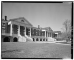 Main building "Sweet Springs Hotel", State Route 311, Sweet Springs in 1933
