
The Northern Belle was an American transatlantic ship which ran aground near Thanet, England, on 5 January 1857. No lives on her were lost, thanks to heroic rescue efforts, in blizzard conditions. However, another ship sank, en route to the scene, the Margate lugger Victory which was lost along with her crew.
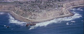
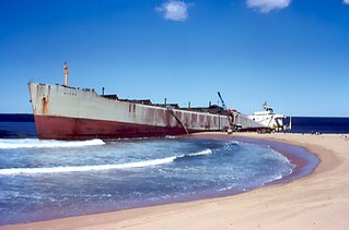
SS Dominator, a freighter, ran ashore on the Palos Verdes Peninsula in the South Bay area of California in 1961 due to a navigational error while lost in fog. Its remains can still be seen today and serves as a point of interest for hikers and kayakers.
MV Sygna was a Norwegian bulk carrier built by Austin & Pickersgill for J. Ludwig Mowinckels Rederi in 1967. It ran aground on Stockton Beach in Australia during a major storm in 1974. After its bow section was refloated, its stern remained beached and became an icon and landmark for the local area, until the visible remains of the wreck collapsed into the sea in 2016.
SS Appomattox was a wooden-hulled, American Great Lakes freighter that ran aground on Lake Michigan, off Atwater Beach off the coast of Shorewood, Wisconsin in Milwaukee County, Wisconsin, United States in 1905. On January 20, 2005 the remnants of the Appomattox were listed on the National Register of Historic Places.

Pasha Bulker, later known as MV Drake and now MV Anthea, is a Panamax bulk carrier of 76,741 tonnes deadweight (DWT) operated by the Lauritzen Bulkers shipping company and owned by Japanese Disponent Owners. While waiting in the open ocean outside Newcastle harbour to load coal, Pasha Bulker ran aground during a major storm on 8 June 2007 on Nobbys Beach, New South Wales, Australia. It was refloated and moved to a safe location offshore on 2 July 2007 before being towed to Japan for major repairs on 26 July 2007.
George was an Australian sloop launched in 1802 and wrecked in 1806. She spent her brief career seal hunting in Bass Strait.
Blackpool and the Fylde coast have become a ship graveyard for a number of vessels over the years. Most of the shipwrecks occurred at or near Blackpool, whilst a few happened a little further afield but have strong connections with the Blackpool area. For this article, Blackpool means the stretch of coast from Fleetwood to Lytham St Annes.
The Moltke was a three-masted barque built in Hamburg, Germany in 1870. The vessel was wrecked off the coast of northern Queensland, Australia in 1890 before being refloated and hulked. In 1911 the vessel was scuttled off Geoffrey Bay, Magnetic Island. The wreck of the vessel now hosts a wide range of underwater life and is a popular open-water dive site.
RMS Duke of Lancaster was a steam turbine passenger ship operated by the London Midland and Scottish Railway from 1928 to 1956 between England and Northern Ireland across the Irish Sea.

Gallinipper was a schooner that sank in Lake Michigan off the coast of Centerville, Manitowoc County, Wisconsin, United States. In 2010, the shipwreck site was added to the National Register of Historic Places.

Carmel Head is a prominent coastal headland on the northwest tip of the island of Anglesey.

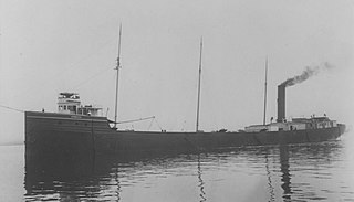
The SS Northwestern, originally SS Oriziba, was a passenger and freight steamship launched in 1889 by the Delaware River Iron Ship Building and Engine Works, Chester, Pennsylvania which spent most of its career in service in the waters of the Territory of Alaska. The ship from early in its career had a reputation for trouble, and was frequently involved in groundings, collisions with other ships, and with port facilities. She first served as a transport in the West Indies as Oriziba, and was acquired by the Northwestern Steamship Company in 1906, sailed around Cape Horn, and renamed Northwestern. For the next thirty years she worked along the Alaska coast, transporting people, mail, and goods, as well as ore from mining operations at Kennecott.

Long Reef is a prominent headland on the Northern Beaches of Sydney, Australia. Connected to the mainland by a tombolo, the reef has an extensive wave-cut platform. Long Reef is a popular recreational destination and is one of the more interesting geological areas in Sydney.
