The Queen Elizabeth Range is a rugged mountain range that parallels the eastern side of Marsh Glacier for nearly 100 nmi from Nimrod Glacier in the north to Law Glacier in the south. Mount Markham, 4,350 metres (14,270 ft) high, is the highest elevation in the range.

The Pensacola Mountains are a large group of mountain ranges and peaks that extend 280 nautical miles in a northeast–southwest direction in the Transantarctic Mountains System, Queen Elizabeth Land region of Antarctica. They comprise the Argentina Range, Forrestal Range, Dufek Massif, Cordiner Peaks, Neptune Range, Patuxent Range, Rambo Nunataks and Pecora Escarpment. These mountain units lie astride the extensive Foundation Ice Stream and Support Force Glacier which drain northward to the Ronne Ice Shelf.
The Argentina Range is a range of rock peaks and bluffs, 42 nautical miles long, lying 35 nautical miles east of the northern part of Forrestal Range in the northeastern portion of the Pensacola Mountains of Antarctica.
The Neptune Range is a mountain range, 70 nautical miles long, lying west-southwest of Forrestal Range in the central part of the Pensacola Mountains, Antarctica. The range comprises Washington Escarpment with its associated ridges, valleys and peaks, the Iroquois Plateau, the Schmidt and the Williams Hills.
The Patuxent Range is a major range of the Pensacola Mountains, Antarctica. It comprises the Thomas Hills, Anderson Hills, Mackin Table and various nunataks and ridges bounded by the Foundation Ice Stream, Academy Glacier and the Patuxent Ice Stream.
The Support Force Glacier is a major glacier in the Pensacola Mountains, draining northward between the Forrestal Range and Argentina Range to the Filchner-Ronne Ice Shelf.

The Churchill Mountains is a major range of mountains and associated elevations bordering the western side of the Ross Ice Shelf, between Byrd Glacier and Nimrod Glacier. They are south of the Britannia Range and north of the Geologists Range, Miller Range and Queen Elizabeth Range.
Foundation Ice Stream is a major ice stream in the Pensacola Mountains of Antarctica. The ice stream drains northward for 150 nautical miles along the west side of the Patuxent Range and the Neptune Range to enter the Ronne Ice Shelf westward of Dufek Massif.

The Dufek Massif is a rugged, largely snow-covered massif 27 nautical miles long, standing west of the Forrestal Range in the northern part of the Pensacola Mountains, Antarctica.
The Jaeger Table is the ice-covered summit plateau of Dufek Massif, in the Pensacola Mountains of Antarctica, rising to 2,030 metres (6,660 ft) at Worcester Summit.
The Boyd Escarpment is a rock and snow escarpment which extends northeast for 10 nautical miles from Wujek Ridge, in the Dufek Massif, Pensacola Mountains, Antarctica. It includes Bennett Spur, Cox Nunatak and Rankine Rock.
Neuburg Peak is a jagged rock peak in Antarctica, 1,840 metres (6,040 ft) high, rising 2.5 nautical miles east of Walker Peak in the southwest part of Dufek Massif, Pensacola Mountains.
The Cordiner Peaks are a group of peaks extending over an area of 6 nautical miles standing 8 nautical miles southwest of Dufek Massif in the northern part of the Pensacola Mountains, Antarctica.
Davis Valley is an ice-free valley just east of Floridas Ridge in north-east Dufek Massif, in the Pensacola Mountains, Antarctica.
The Lexington Table is a high, flat, snow-covered plateau, about 15 nautical miles long and 10 nautical miles wide, standing just north of Kent Gap and Saratoga Table in the Forrestal Range, Pensacola Mountains, Antarctica.
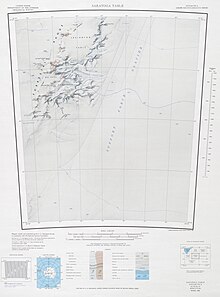
The Saratoga Table is a high, flat, snow-covered plateau, 8 nautical miles long and 6 nautical miles wide, standing just south of Kent Gap and Lexington Table in the southern Forrestal Range, Pensacola Mountains, Antarctica.
Mount Malville is a mountain, 1,030 metres (3,380 ft) high, standing 5 nautical miles southwest of Ackerman Nunatak in the northern part of the Forrestal Range, Pensacola Mountains, Antarctica.
Sallee Snowfield is a large snowfield between the Dufek Massif and northern Forrestal Range in the Pensacola Mountains, Antarctica.
Torbert Escarpment is an escarpment, 15 nautical miles long, marking the west margin of Median Snowfield in the Neptune Range, Pensacola Mountains, Antarctica.
The Kester Peaks are three aligned rock peaks standing together 5 nautical miles south of Mount Malville on the east side of the Forrestal Range, in the Pensacola Mountains, [Antarctica.

