Fort Antes

Last updated
Fort Antes
USA Pennsylvania location map.svg
Red pog.svg
Map of the U.S. state of Pennsylvania showing the location of Fort Antes
Location Nippenose Township, Pennsylvania, USA
Nearest city Jersey Shore, Pennsylvania
Coordinates 41°11′28″N77°14′19″W / 41.19111°N 77.23861°W / 41.19111; -77.23861
Area0.75 acres (3,000 m2)
Built/founded1777 or 1778
PHMC dedicatedJune 8, 1917
May 1, 1947

Fort Antes was a stockade surrounding the home of Colonel John Henry Antes, built circa 1778 in Revolutionary Pennsylvania in the United States. The fort was built under the direction of Colonel Antes, who was a member of the Pennsylvania militia. It was on the east side of Antes Creek, overlooking and on the left bank of the West Branch Susquehanna River on a plateau in Nippenose Township south of modern day Jersey Shore in western Lycoming County. The local militia held the fort for a short period of time until it was ordered to abandon Fort Antes during the Big Runaway by Colonel Samuel Hunter. [1] Despite being abandoned and attempts by the attacking British forces to burn it down, Fort Antes was one of only two structures in the valley to survive the Big Runaway.

Contents

John Henry Antes

John Henry Antes settled along the West Branch Susquehanna River circa 1772. His property was on the very edge of the Pennsylvania frontier. Antes’ neighbors on the north side of the West Branch Susquehanna and west of Lycoming Creek were outside the jurisdiction of the colonial government of Pennsylvania. They banded together to form the Fair Play Men. Antes, as a Justice of the Peace for what was then Northumberland County, worked closely with the Fair Play Men. He conducted their weddings and his stockade provided some protection against raids conducted by local Native Americans, who began fighting back against the encroachment of the Europeans. [2] Antes built a gristmill along Antes Creek in 1773. It was the most advanced construction of any kind in frontier north-central Pennsylvania. [1] John Henry Antes served as a Justice of the Peace from July 29, 1775, until January 24, 1776, when he was appointed captain of 58 militiamen under Colonel James Potter. After participating in a raid conducted by Colonel William Plunket against settlers from Connecticut in the Wyoming Valley near Wilkes-Barre, Antes returned to his gristmill, home and future fort in mid-1777. He also was promoted to Lieutenant Colonel that same year.

Frontier Outpost

The Lenape allies of the British began conducting raids on the Pennsylvania frontier soon after the outset of the American Revolution. An attack at the mouth of Pine Creek in December 1777 and another attack further upstream, near modern Lock Haven, prompted action by Pennsylvania's militia to try to protect the frontiersmen on the West Branch Susquehanna River. Colonel Samuel Hunter ordered Colonel Antes to gather a force of men from the West Branch Valley to gather at Antes' property. The men of the militia built a stockade that was at least 12 feet (4 m) high around the Antes home. [1] The stockade enclosed approximately three quarters of an acre (3,000 m²). Colonel Antes was forced to defend an extensive frontier that was under steady attack from Native American and Tory forces that were dispatched to Pennsylvania from Fort Niagara on Lake Ontario in New York.

This historical marker for Fort Antes is in Jersey Shore, Pennsylvania, across the West Branch Susquehanna River from Nippenose Township. Fort Antes Marker.JPG
This historical marker for Fort Antes is in Jersey Shore, Pennsylvania, across the West Branch Susquehanna River from Nippenose Township.

Two settlers who were staying near Fort Antes were killed in June 1777. A party of four men and two women had left the safety of the fort and crossed the West Branch of the Susquehanna River to milk some cows that had been left there to pasture. Zephaniah Miller, Abel Cady, and James Armstrong left the riverbank and meadow to gather a cow who had wandered into the surrounding woods. These three men came under attack by a group of warriors who had been hiding in the woods. Sounds of fighting stirred the men at the fort. They crossed the river despite the objections of Colonel Antes who thought that the Native Americans might have set a trap. Upon reaching the other side of the river, the militiamen found Miller dead and Cady and Armstrong mortally wounded. Only Bouser and the women, one of them Cady's wife, survived the attack. This was just one of many attacks in the West Branch Valley that continued to make life more dangerous for the settlers, who were encroaching on tribal land.

All of these attacks and the lack of military help from the Pennsylvania government disheartened the settlers along the West Branch of the Susquehanna. News of impending attacks caused much worry among the settlers and the leaders of the militia. This news was provided by a friendly Native American named Job Chilloway at Fort Reed (modern Lock Haven), who had been converted to Christianity by Moravian missionaries. The Battle of Wyoming occurred on July 3, 1778 (near what is now Wilkes-Barre). A mass attack there overwhelmed small settler forts. Widely reported, but since discredited, reports of a massacre caused the local authorities to order the evacuation of the whole West Branch valley. [2] Although Colonel Antes and his men were successful in building Fort Antes, they were forced to abandon their efforts in July 1778 during the Big Runaway. The raiding parties of Indians and Tories were too numerous for the militia and farmers to defend their lives and property.

The Big Runaway

Robert Covenhoven, who had served under George Washington in the Continental Army, rode west along the ridge of Bald Eagle Mountain to warn settlers and the militia at Fort Antes. [3] Covenhoven followed the ridge for two reasons: first, experience told him that the Native Americans would not be on the level summit of the ridge, thus making him safe from personal attack, and second, he would be able to scout the situation in the valley from atop the ridge. Covenhoven, who was joined by an unnamed employee of Culbertson's Mill in modern Duboistown, was able to see Fort Antes from the ridge. As he slowly approached the stockade, Covenhoven heard the report of a rifle shot and made a run for the fort thinking that he was under fire. This proved to be false - although there were Native Americans in the area and one did fire his weapon, the fire was not aimed at Robert Covenhoven. Instead, a young woman outside the stockade milking a cow was the target, as evidenced by the bullet hole that pierced the folds of her dress. After giving the orders that prompted the Big Runaway, Covenhoven returned to Fort Augusta. [1] Covenhoven is listed as a Fair Play Man and one of the signers of the Tiadaghton Declaration of Independence. Following the war, he continued to serve as a scout on the frontier before retiring to Piatt Township on the north side of the West Branch Susquehanna River. [4]

Map of fortifications and streams in north-central Pennsylvania during the Big Runaway. Fort Antes is in western Lycoming County on the south side of the West Branch Susquehanna River. Big Runaway Map.PNG
Map of fortifications and streams in north-central Pennsylvania during the Big Runaway. Fort Antes is in western Lycoming County on the south side of the West Branch Susquehanna River.

Most settlers had already gathered at Fort Antes, prior to Covenhoven's arrival, but now the fort and the settlers' homes and fields were abandoned, with livestock driven along and a few possessions floated on rafts on the river east to what is now Muncy, then further south to Fort Augusta at what is now Sunbury. Women and children rode on the rafts, while the men walked on the river bank to protect them and to drive along the livestock they had been able to save. Their abandoned property was burnt by the attackers. Some settlers reported fleeing at night, with the glow of their burning settlements lighting the sky behind them.

Fort Horn and the other Fair Play Men settlements were all destroyed. Only Fort Antes (made of hard-to-burn peeled oak logs) and the fortified Wallis House (made of stone) in Muncy Township survived the flames. The property losses were estimated at £40,000, and there were deaths among the settlers. Colonel Hunter, the commander of Fort Augusta who had ordered the mass evacuation, was criticized roundly. Many at the time felt that military assistance would have allowed the settlers to withstand the attackers. [3]

Post war years

Colonel Henry Antes was one of the first settlers to return to the West Branch Valley following the Big Runaway. He found that his mill had been destroyed, but that his home within the fort had not. Antes soon built a larger home on Antes Creek and the fort was abandoned. It gradually decayed before being dismantled. The ground was leveled and then farmed, and today there are no remnants of Fort Antes to be seen above the ground. Colonel Antes was elected the sheriff of Northumberland County in 1782, thirteen years before Lycoming County was established. John Henry Antes died on May 18, 1820, when he was 83 years old.

Colonel Antes' grave marker Colonel Antes Tombstone.JPG
Colonel Antes' grave marker

Related Research Articles

<span class="mw-page-title-main">Jersey Shore, Pennsylvania</span> Borough in Pennsylvania, United States

Jersey Shore is a borough in Lycoming County, Pennsylvania, United States. It is on the West Branch Susquehanna River, 15 miles (24 km) west by south of Williamsport. It is part of the Williamsport, Pennsylvania Metropolitan Statistical Area. In the past, Jersey Shore held farms, railroad shops, cigar factories, a foundry, and a large silk mill. The population was 4,158 at the 2020 census.

<span class="mw-page-title-main">Lewis Township, Lycoming County, Pennsylvania</span> Township in Pennsylvania, United States

Lewis Township is a township in Lycoming County, Pennsylvania, United States. The population was 987 at the 2010 census, down from 1,139 in 2000. It is part of the Williamsport Metropolitan Statistical Area.

<span class="mw-page-title-main">Loyalsock Township, Pennsylvania</span> Township in Pennsylvania, United States

Loyalsock Township is a township in Lycoming County, Pennsylvania, United States. The population was 11,561 at the 2020 census. It is part of the Williamsport Metropolitan Statistical Area. It is the second largest municipality in Lycoming County, in terms of population, behind the county seat, Williamsport.

<span class="mw-page-title-main">Muncy Township, Lycoming County, Pennsylvania</span> Township in Pennsylvania, United States

Muncy Township is a township in Lycoming County, Pennsylvania, United States. The population was 1,177 at the 2020 census. It is part of the Williamsport Metropolitan Statistical Area.

<span class="mw-page-title-main">Nippenose Township, Pennsylvania</span> Township in Pennsylvania, United States

Nippenose Township is a township in Lycoming County, Pennsylvania, United States. The population was 662 at the 2020 census. It is part of the Williamsport, Pennsylvania Metropolitan Statistical Area.

<span class="mw-page-title-main">Old Lycoming Township, Pennsylvania</span> Township in Pennsylvania, United States

Old Lycoming Township is a township in Lycoming County, Pennsylvania, United States. The population was 4,973 at the 2020 census down from 4,938 in 2010. It is part of the Williamsport Metropolitan Statistical Area.

<span class="mw-page-title-main">Piatt Township, Pennsylvania</span> Township in Pennsylvania, United States

Piatt Township is a township in Lycoming County, Pennsylvania, United States. The population was 1,045 at the 2020 census. It is part of the Williamsport Metropolitan Statistical Area.

<span class="mw-page-title-main">Porter Township, Lycoming County, Pennsylvania</span> Township in Pennsylvania, United States

Porter Township is a township in Lycoming County, Pennsylvania, United States. The population was 1,535 at the 2020 census. It is part of the Williamsport Metropolitan Statistical Area.

<span class="mw-page-title-main">Washington Township, Lycoming County, Pennsylvania</span> Township in Pennsylvania, United States

Washington Township is a township in Lycoming County, Pennsylvania, United States. The population was 1,769 at the 2020 census. It is part of the Williamsport Metropolitan Statistical Area.

<span class="mw-page-title-main">Woodward Township, Lycoming County, Pennsylvania</span> Township in Pennsylvania, United States

Woodward Township is a township in Lycoming County, Pennsylvania, United States. The population was 2,043 at the 2020 census, down from 2,200 in 2010. It is part of the Williamsport Metropolitan Statistical Area.

<span class="mw-page-title-main">West Branch Susquehanna River</span> River in Pennsylvania, United States

The West Branch Susquehanna River is one of the two principal branches, along with the North Branch, of the Susquehanna River in the Northeastern United States. The North Branch, which rises in upstate New York, is generally regarded as the extension of the main branch, with the shorter West Branch being its principal tributary.

<span class="mw-page-title-main">Lycoming Creek</span> River in Pennsylvania, United States

<span class="mw-page-title-main">White Deer Hole Creek</span> Tributary of the West Branch Susquehanna River

White Deer Hole Creek is a 20.5-mile (33.0 km) tributary of the West Branch Susquehanna River in Clinton, Lycoming and Union counties in the U.S. state of Pennsylvania. A part of the Chesapeake Bay drainage basin, the White Deer Hole Creek watershed drains parts of ten townships. The creek flows east in a valley of the Ridge-and-valley Appalachians, through sandstone, limestone, and shale from the Ordovician, Silurian, and Devonian periods.

<span class="mw-page-title-main">Fair Play Men</span>

The Fair Play Men were illegal settlers (squatters) who established their own system of self-rule from 1773 to 1785 in the West Branch Susquehanna River valley of Pennsylvania in what is now the United States. Because they settled in territory claimed by Native Americans, they had no recourse to the Pennsylvania colonial government. Accordingly they established what was known as the Fair Play System, with three elected commissioners who ruled on land claims and other issues for the group. In a remarkable coincidence, the Fair Play Men made their own declaration of independence from Britain on July 4, 1776 beneath the "Tiadaghton Elm" on the banks of Pine Creek.

Fort Augusta was a stronghold in Northumberland County, Pennsylvania, in the upper Susquehanna Valley from the time of the French and Indian War to the close of the American Revolution. At the time, it was the largest British fort in Pennsylvania, with earthen walls more than two hundred feet long topped by wooden fortifications. With a garrison of over 300 troops and walls specially constructed to resist artillery, it presented a formidable defense and was never attacked. It served as a refuge for local settlers during the French and Indian War and during the American Revolutionary War. It was abandoned in 1780 and dismantled in 1796.

<span class="mw-page-title-main">West Branch Susquehanna Valley</span>

The West Branch Susquehanna Valley of central Pennsylvania, United States, in the Ridge-and-valley Appalachians, is the low-lying area draining into the West Branch Susquehanna River southeast of the Allegheny Front, northeast of the Bald Eagle Valley, southwest of the Wyoming Valley and north of the water gap formed between Shamokin Mountain and Montour Ridge.

<span class="mw-page-title-main">History of Lycoming County, Pennsylvania</span>

This article details a history of Lycoming County, Pennsylvania.

<span class="mw-page-title-main">Big Runaway</span>

The Big Runaway was a mass evacuation in June and July 1778 of settlers from the frontier areas of north central Pennsylvania during the American Revolutionary War. A major campaign by Loyalists and Native Americans allied with the British devastated the small communities on the northern and western branches of the Susquehanna River, prompting local militia leaders to order the evacuation. Most of the settlers relocated to Fort Augusta at modern-day Sunbury at the confluence of the North and West Branches of the Susquehanna River, while their abandoned houses and farms were all burnt.

Williamsport was incorporated as a borough on March 1, 1806, and as a city on January 15, 1866. The city is the original home of Little League Baseball, founded in 1939 as a three-team league.

<span class="mw-page-title-main">Fort Granville</span>

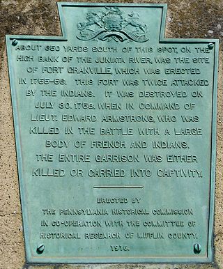
Fort Granville was a militia stockade located in the colonial Province of Pennsylvania. Its site was about a mile from Lewistown, in what is now Granville Township, Mifflin County. Active from 1755 until 1756, the stockade briefly sheltered pioneer settlers in the Juniata River valley during the French and Indian War. The fort was attacked on August 2, 1756, by a mixed force of French troops and Native Americans, mostly Lenape warriors. The fort’s garrison surrendered the strongpoint to these attackers, who celebrated their victory and destroyed the stockade.

References

  1. 1 2 3 4 Buckalew, John M. (1896). REPORT OF THE COMMISSION TO LOCATE THE SITE OF THE FRONTIER FORTS IN PENNSYLVANIA: The Frontier Forts Within The North And West Branches of the Susquehanna River (VOLUME ONE ed.). Harrisburg, PA: Clarence M. Bush: State Printer of Pennsylvania. Retrieved 2007-04-24.
  2. 1 2 Meginness, John Franklin (1892). http://www.usgennet.org/usa/pa/county/lycoming/history/Chapter-34.html. History of Lycoming County, Pennsylvania: including its aboriginal history; the colonial and revolutionary periods; early settlement and subsequent growth; organization and civil administration; the legal and medical professions; internal improvement; past and present history of Williamsport; manufacturing and lumber interests; religious, educational, and social development; geology and agriculture; military record; sketches of boroughs, townships, and villages; portraits and biographies of pioneers and representative citizens, etc. etc (1st ed.). Chicago, IL: Brown, Runk & Co. ISBN   0-7884-0428-8 . Retrieved 2007-04-24. (Note: ISBN refers to Heritage Books July 1996 reprint. URL is to a scan of the 1892 version with some OCR typos).{{cite book}}: |chapter-url= missing title (help)
  3. 1 2 A Picture of Lycoming County. The Lycoming County Unit of the Pennsylvania Writers Project of the Work Projects Administration (First ed.). The Commissioners of Lycoming County Pennsylvania. 1939. Archived from the original (PDF) on 2009-04-21. Retrieved 2007-04-24.{{cite book}}: CS1 maint: others (link)
  4. Robin Van Auken. "A Heroic Duo". Originally appeared in the Williamsport Sun Gazette. Archived from the original on 2012-02-09. Retrieved 2012-02-15.