Fort Bainbridge

Last updated
Fort Bainbridge
Boromville, Alabama in United States
Fort Bainbridge.jpg
USA Alabama location map.svg
Red pog.svg
Fort Bainbridge
Usa edcp location map.svg
Red pog.svg
Fort Bainbridge
Coordinates 32°19′08″N85°26′06″W / 32.31889°N 85.43500°W / 32.31889; -85.43500
TypeEarthen fort
Site information
OwnerPrivate
Controlled byPrivate
Open to
the public
No
Site history
BuiltMarch 1814
Built byNorth Carolina militia
In use1814
Battles/wars Creek War

Fort Bainbridge was an earthen fort located along the Federal Road on what is today the county line between Macon and Russell counties in Alabama. [1] Fort Bainbridge was located twenty-five miles west of Fort Mitchell. [2]

Contents

History

Creek War

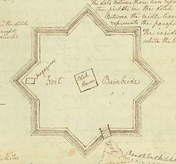
Fort Bainbridge was named in honor of naval captain William Bainbridge. [3] [4] Fort Bainbridge was built in the style of a bastion fort with eight outcroppings. The bastions were surrounded by a ditch that was filled with pickets and the fort was entered by a drawbridge. [5] It was constructed in March 1814 by North Carolina militia under the command of General Joseph Graham in an effort to protect the supply route from Fort Hull to Fort Mitchell. [6] Captain Jett Thomas directed the fort's construction. [7] Fort Bainbridge allowed supply wagons to travel between Fort Mitchell and Hull in one-day intervals and was garrisoned by 100 to 300 troops. [8] Fort Bainbridge was garrisoned by Tennessee militia until July 31, 1814. [2]

Postwar

In 1820 on his North American tour, Adam Hodgson described Fort Bainbridge as being a "small stockaded mound". [7] Captain Kendall Lewis (who commanded Benjamin Hawkins' scouts), along with his Creek chief father-in law, Big Warrior, operated a tavern as a stagecoach stop about 400 yards west of Fort Bainbridge, which stayed open under the care of Lewis' widow until at least 1836. [9] During his return tour, the Marquis de Lafayette stayed at the Lewis Tavern for his first night in Alabama. [10] Prince Bernhard of Saxe-Weimar-Eisenach stayed at the Lewis Tavern on his 1826 travels through North America. [11] The site of the fort also lies along naturalist William Bartram's four-year journey through the Southern United States, during which he documented the flora, fauna and Native Americans of the area. [12] The fort site was later used as a plantation. [13]

Fort Bainbridge (located in the center) as portrayed in Henry Schenck Tanner's 1830 The Traveler's Pocket Map of Alabama. Fort Bainbridge and Decatur.jpg
Fort Bainbridge (located in the center) as portrayed in Henry Schenck Tanner's 1830 The Traveler's Pocket Map of Alabama.

Present

Today, it remains unmarked and its legacy lies in a small unincorporated community, Boromville, that developed from it. [14] Though unmarked, the location is known and the area has been damaged by relic hunters. [15]

Related Research Articles

<span class="mw-page-title-main">Creek War</span> 1813–14 US Indian War

The Creek War, was a regional conflict between opposing Native American factions, European powers, and the United States during the early 19th century. The Creek War began as a conflict within the tribes of the Muscogee, but the United States quickly became involved. British traders and Spanish colonial officials in Florida supplied the Red Sticks with weapons and equipment due to their shared interest in preventing the expansion of the United States into regions under their control.

<span class="mw-page-title-main">Fort Mims massacre</span> Part of the Creek War (1813)

The Fort Mims massacre took place on August 30, 1813, during the Creek War, when a force of Creek Indians belonging to the Red Sticks faction, under the command of head warriors Peter McQueen and William Weatherford, stormed the fort and defeated the militia garrison. Afterward, a massacre ensued and almost all of the remaining mixed Creek, white settlers, and militia at Fort Mims were killed. The fort was a stockade with a blockhouse surrounding the house and outbuildings of the settler Samuel Mims, located about 35 miles directly north of present-day Mobile, Alabama.

<span class="mw-page-title-main">Fort Williams (Alabama)</span> United States historic site

Fort Williams was a supply depot built in early 1814 in preparation for the Battle of Horseshoe Bend. It was located in Alabama on the southeast shore where Cedar Creek meets the Coosa River, near Talladega Springs.

Creek Stand is an unincorporated community in Macon County, Alabama, United States.

Old Alabama Town is a collection of restored 19th- and 20th-century structures reflecting the lives of the people who settled and developed central Alabama. It stretches along six blocks in the heart of historic downtown Montgomery, Alabama, depicting a cross-section of architecture, history, and lifestyles from an elegant townhouse to rural pioneer living.

<span class="mw-page-title-main">Fort Strother</span> United States historic site

Fort Strother was a stockade fort at Ten Islands in the Mississippi Territory, in what is today St. Clair County, Alabama. It was located on a bluff of the Coosa River, near the modern Neely Henry Dam in Ragland, Alabama. The fort was built by General Andrew Jackson and several thousand militiamen in November 1813, during the Creek War and was named for Captain John Strother, Jackson's chief cartographer.

<span class="mw-page-title-main">Canoe Fight (Creek War)</span> Skirmish with Native Indians

<span class="mw-page-title-main">Fort Claiborne</span> United States historic site in Alabama

Fort Claiborne was a stockade fort built in 1813 in present-day Monroe County, Alabama during the Creek War.

Snowdoun is an unincorporated community in Montgomery County, Alabama, United States. Snowdoun is located on U.S. Highway 331 9.5 miles (15.3 km) south of Montgomery.

Pintlala, also known as Pint Lala or Colquitt, is an unincorporated community in Montgomery County, Alabama, United States, located on U.S. Route 31, 15.6 miles (25.1 km) south of Montgomery.

Waugh is an unincorporated community in Montgomery County, Alabama, United States, located at the intersection of U.S. Route 80 and Alabama State Route 126, 15.3 miles (24.6 km) east of Montgomery.

<span class="mw-page-title-main">Fort Decatur (Alabama)</span> United States historic site

Fort Decatur was an earthen fort established in March 1814 on the banks of the Tallapoosa River as part of the Creek War and the larger War of 1812. The fort was located on the east bank of the Tallapoosa River, near the modern community of Milstead. Fort Decatur was also located near the Creek town of Tukabatchee. It was most likely named for Stephen Decatur.

<span class="mw-page-title-main">Fort Dale</span> Stockade fort built in present-day Butler County, Alabama, United States

Fort Dale was a stockade fort built in present-day Butler County, Alabama by Alabama Territory settlers. The fort was constructed in response to Creek Indian attacks on settlers in the surrounding area.

<span class="mw-page-title-main">Fort Hull</span> American historical site in Alabama

Fort Hull was an earthen fort built in present-day Macon County, Alabama in 1814 during the Creek War. After the start of hostilities, the United States decided to mount an attack on Creek territory from three directions. The column advancing west from Georgia built Fort Mitchell and then clashed with the Creeks. After a pause in operations, the column from Georgia continued its march and built Fort Hull. The fort was used as a supply point and was soon abandoned after the end of the Creek War.

Sehoy, or Sehoy I, was an 18th-century matriarch of the Muscogee Confederacy and a member of the Wind clan.

<span class="mw-page-title-main">Fort Madison (Alabama)</span> United States historic site in Alabama

Fort Madison was a stockade fort built in August 1813 in present-day Clarke County, Alabama, during the Creek War, which was part of the larger War of 1812. The fort was built by the United States military in response to attacks by Creek warriors on encroaching American settlers. The fort shared many similarities to surrounding stockade forts in its construction but possessed a number of differences in its defenses. The fort housed members of the United States Army and settlers from the surrounding area, and it was used as a staging area for raids on Creek forces and supply point on further military expeditions. Fort Madison was subsequently abandoned at the conclusion of the Creek War and only a historical marker exists at the site today.

Fort Montgomery was a stockade fort built in August 1814 in present-day Baldwin County, Alabama, during the Creek War, which was part of the larger War of 1812. The fort was built by the United States military in response to attacks by Creek warriors on encroaching American settlers and in preparation for further military action in the War of 1812. Fort Montgomery continued to be used for military purposes but in less than a decade was abandoned. Nothing exists at the site today.

<span class="mw-page-title-main">Fort Okfuskee</span> United States historic site in Alabama

Fort Okfuskee was the name of two separate forts built by Great Britain in what is now Tallapoosa County, Alabama. The first fort was built to ensure British trade with the Creek Indians after the French constructed Fort Toulouse. The fort was abandoned a little over a decade after construction after facing difficulties in being supplied. A second Fort Okfuskee was built a year later, but was abandoned in less than a year due to lack of colonial support.

Fort Pierce, was two separate stockade forts built in 1813 in present-day Baldwin County, Alabama, during the Creek War, which was part of the larger War of 1812. The fort was originally built by settlers in the Mississippi Territory to protect themselves from attacks by Creek warriors. A new fort of the same name was then built by the United States military in preparation for further action in the War of 1812, but the fort was essentially abandoned within a few years. Nothing exists at the site today.

<span class="mw-page-title-main">Sandfort, Alabama</span> Unincorporated community in Alabama, United States

Sandfort, also rendered Sand Fort or Sanfort and also known as Lexington, is an unincorporated community in Russell County, Alabama, United States.

References

  1. Harris 1977, pp. 36.
  2. 1 2 Jackson 1927, pp. 23.
  3. Bunn & Williams 2008, pp. 42.
  4. Brannon, Peter A. (April 17, 1932). "Fort Bainbridge, In Russell". The Montgomery Advertiser. Montgomery, Alabama. Retrieved September 4, 2021.
  5. Waselkov & Christopher 2012, pp. 42.
  6. Waselkov & Christopher 2012, pp. 222.
  7. 1 2 Brannon, Peter A. (April 17, 1932). "Fort Bainbridge, In Russell". The Montgomery Advertiser. Montgomery, Alabama. Retrieved September 4, 2021.
  8. Owsley 2008, pp. 60.
  9. "Stage Stops and Taverns of Early Alabama Prior to 1840". Genealogy Trails. Retrieved 5 March 2017.
  10. "Alabama threw parties for Lafayette [photographs] and Selma played a prank on the citizens of their town". Alabama Pioneers. 3 May 2016. Retrieved 5 March 2017.
  11. Waselkov & Christopher 2012, pp. 204.
  12. Bartram Trail Conference 1979, pp. 134.
  13. Braund, Waselkov & Christopher 2019, pp. 100.
  14. "Highlights". The Ridge Macon County Archaeology Project. Retrieved 2 May 2021.
  15. Braund 2012, pp. 249.

Sources