E-ZPass is an electronic toll collection system used on toll roads, toll bridges, and toll tunnels in the Eastern United States, Midwestern United States, and Southern United States. The E-ZPass Interagency Group (IAG) consists of member agencies in several states, which use the same technology and allow travelers to use the same transponder on toll roads throughout the network.

The Kansas Turnpike is a 236-mile-long (380 km), freeway-standard toll road that lies entirely within the US state of Kansas. It runs in a general southwest–northeast direction from the Oklahoma border to Kansas City. It passes through several major Kansas cities, including Wichita, Emporia, Topeka, and Lawrence. The turnpike is owned and maintained by the Kansas Turnpike Authority (KTA), which is headquartered in Wichita.

SunPass is an electronic toll collection system within the state of Florida, United States. It was created in 1999 by the Florida Department of Transportation's (FDOT's) Office of Toll Operations, operating now as a division of Florida's Turnpike Enterprise (FTE). The system utilizes windshield-mounted RFID transponders manufactured by TransCore and lane equipment designed by companies including TransCore, SAIC, and Raytheon.
State Highway 360 is a 28-mile (45 km) north–south state highway in the Dallas–Fort Worth metroplex in the U.S. state of Texas. It runs north from an at-grade intersection with US 287 in Mansfield, near the Ellis-Johnson county line to a partial interchange with SH 121 in Grapevine, near Dallas/Fort Worth International Airport. The highway serves as a local north–south route running through the center of the metroplex, linking together the southern and northern suburbs to the core. Between US 287 and Camp Wisdom Road/Sublett Road, SH 360 follows a pair of frontage roads along a four-lane tollway known as the 360 Tollway, a tollway operated by the NTTA. Between Camp Wisdom Road/Sublett Road and SH 121, SH 360 follows a toll-free freeway maintained by TxDOT.
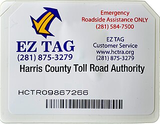
EZ TAG is an electronic toll collection system in Houston, Texas, United States, that allows motorists to pay tolls without stopping at toll booths. Motorists with the tags are allowed to use lanes reserved exclusively for them on all Harris County Toll Road Authority (HCTRA) roads. As of late 2003, the EZ TAG can also be used on all lanes of tolled roadways in Texas that accommodate electronic toll collection.

State Highway 99, also known as the Grand Parkway, is a ring road in the U.S. state of Texas. Its first section opened on August 31, 1994. When the route is completed, it will be the longest beltway in the U.S., the world's seventh-longest ring road, and the third (outer) loop of the Houston–The Woodlands–Sugar Land metropolitan area, with Interstate 610 being the first (inner) loop and Beltway 8 being the second (middle) loop. The proposed 170-mile (270 km) loop has been divided into 11 separate segments for construction and funding purposes. In May 2019, the Texas Department of Transportation gave the Grand Parkway a secondary designation as the Mayor Bob Lanier Memorial Parkway, honoring Bob Lanier, who served as the mayor of Houston from 1992 to 1998 and who had spearheaded the creation of the Grand Parkway.
The President George Bush Turnpike (PGBT) is a 52-mile (84 km) toll road running through the northern, northeastern and western suburbs, forming a partial loop around Dallas, Texas, United States. It is named for the late George H. W. Bush, the 41st president of the United States. At its west end near Belt Line Road in Irving, State Highway 161 continues southwest to Interstate 20 (I-20) in Grand Prairie. The discontinuous free frontage roads along the turnpike from I-35E in Carrollton east to its end at I-30 in Garland are assigned the State Highway 190 designation. SH 190 signage appears only along the Rowlett, Garland, Richardson, Plano, and Carrollton sections of the frontage road with the undersign "frontage road only". At intersections with city streets, only the Bush Turnpike signs are displayed, not the SH 190 signage. Prior to the construction of the main lanes as a tollway, SH 190 was used as the name of the planned main lanes too. Similarly, the part west of I-35E was planned as part of SH 161. Bush Turnpike is signed as a north–south road from I-20 to I-35E, an east–west road from I-35E to the Merritt Main Lane Gantry and as a north–south road from the Merritt Main Lane Gantry to I-30, as Bush Turnpike makes a nearly 90-degree curve in both places.

The Dallas North Tollway is a 30.2-mile (49 km) controlled-access toll road operated by the North Texas Tollway Authority (NTTA), which runs from Interstate 35E near downtown Dallas, Texas (USA), to U.S. Highway 380, in Frisco, Texas.

State Highway 249, also known depending on its location as West Mount Houston Road, the Tomball Parkway, Tomball Tollway, MCTRA 249 Tollway, or the Aggie Expressway, is a 49.443-mile (79.571 km) generally north–south highway in Southeast Texas. The southern terminus is in North Houston at Interstate 45 (I-45). The current northern terminus of the highway is east of Navasota at SH 105.

The Westpark Tollway, also Fort Bend Westpark Tollway, is a limited-access toll road in Texas, serving western Houston and Harris County, and northeastern Fort Bend County. Construction on the facility began in 2001 and portions of the road were opened to traffic in May 2004. Construction of the roadway was completed in August 2005. The Westpark Tollway begins on Westpark Drive just past the South Rice Avenue intersection in the Uptown District of Houston and runs approximately 22 miles (35 km) west to Farm to Market Road 1093 just past Farm to Market Road 723 in Fulshear, Texas. It runs roughly parallel and to the south of Westheimer Road in Harris County and concurrently with FM 1093 in Fort Bend County.

TxTag, operated by the Texas Department of Transportation (TxDOT), is one of three interoperable electronic toll collection systems in Texas. The system is also interoperable with the K-TAG system used in Kansas and the Pikepass system used in Oklahoma.
The North Texas Tollway Authority (NTTA) is an organization that maintains and operates toll roads, bridges, and tunnels in the North Texas area. Functioning as a political subdivision of the State of Texas under Chapter 366 of the Transportation Code, the NTTA is empowered to acquire, construct, maintain, repair and operate turnpike projects; to raise capital for construction projects through the issuance of turnpike revenue bonds; and to collect tolls to operate, maintain and pay debt service on those projects.

The Fort Bend Parkway Toll Road is the Fort Bend County (i.e.,southern) portion of a continuous toll road connecting Sienna in eastern Fort Bend County to US 90A in southwestern Harris County. It is administered by the Fort Bend County Toll Road Authority (FBCTRA). The Harris County Toll Road Authority (HCTRA) administers the Harris County segment of the road — from just south of Beltway 8 at the county line to US 90A — and uses its purple pentagonal shield labeled as Fort Bend Toll Road. It is proposed to reach a northern terminus at the southwestern corner of Interstate 610 in the future, and SH 99 at its southern terminus.
The Harris County Toll Road Authority maintains and operates a 103-mile (165.8 km) toll road system in the Greater Houston area of Texas, United States. Its headquarters are located in Houston's Fairbanks/Northwest Crossing neighborhood.

Sam Houston Tollway Ship Channel Bridge is a span in Harris County, Texas. It was acquired from the then–Texas Turnpike Authority (TTA) on May 5, 1994, and is now a part of the Harris County Toll Road Authority system. The bridge opened to traffic in May 1982 and carries four lanes of the Sam Houston Tollway over the Houston Ship Channel with a clearance of 175 feet (53 m).

There are many toll roads in the United States; as of 2006, toll roads exist in 35 states, with the majority of states without any toll roads being in the West and South. In 2015, there were 5,000 miles (8,000 km) of toll roads in the country.
There are approximately 25 current toll roads in the state of Texas. Toll roads are more common in Texas than in many other U.S. states, since the relatively low revenues from the state's gasoline tax limits highway planners' means to fund the construction and operation of highways.
The Montgomery County Toll Road Authority (MCTRA), formerly the Montgomery County Transportation Program (MCTP), is a government agency created on August 24, 2006 by Montgomery County to oversee all future toll road projects within the county. MCTRA operates one toll road: the MCTRA 249 Tollway, which serves as the tolled mainlines of SH 249. This toll projects are located inside of Montgomery County, in the U.S. state of Texas.
NationalPass is an interoperable service created by TransCore, which is designed to eventually provide single transponder access to all public toll roads and bridges in North America.