
Little Elm is a city in Denton County, Texas, United States, and a part of the Dallas-Fort Worth Metroplex. It is an extended suburb of Denton. The population was 3,646 at the 2000 census. By the 2010 census, the city total had jumped to 25,898, making Little Elm one of the fastest growing municipalities in Texas since 2000 in terms of percentage. As of 2019 the current estimated population of Little Elm is 53,126.

Interstate 355 (I-355), also known as the Veterans Memorial Tollway, is an Interstate Highway and tollway in the western and southwest suburbs of Chicago in the U.S. state of Illinois. Like most other toll roads in the northeastern portion of the state, I-355 is maintained by the Illinois State Toll Highway Authority (ISTHA). I-355 runs from I-80 in New Lenox north to I-290 in Itasca, a distance of 32.5 miles (52.3 km). With the exception of a four-mile (6.4 km) expansion in 2009, from U.S. Route 34 to 75th Street, the highway is six lanes wide for its entire length.
State Highway 121 is a state highway angling from southwest to northeast through north central Texas. It runs from downtown Fort Worth, Texas at the junction of Interstate 35W to Bonham, Texas, just north of a junction with U.S. Highway 82.

State Highway 360 is a 28-mile (45 km) north–south state highway in the Dallas–Fort Worth metroplex in the U.S. state of Texas. It runs north from an at-grade intersection with US 287 in Mansfield, near the Ellis-Johnson county line to a partial interchange with SH 121 in Grapevine, near Dallas/Fort Worth International Airport. The highway serves as a local north–south route running through the center of the metroplex, linking together the southern and northern suburbs to the core. Between US 287 and Camp Wisdom Road/Sublett Road, SH 360 follows a pair of frontage roads along a four-lane tollway known as the 360 Tollway, a tollway operated by the NTTA. Between Camp Wisdom Road/Sublett Road and SH 121, SH 360 follows a toll-free freeway maintained by TxDOT.

White Rock Creek is a 30-mile (48.3 km) creek occupying a chain of four sub-watersheds [1] within the Trinity River Headwaters watershed. From its source near Frisco, Texas at 42°21'36"N/96°46'54.58"W, this creek runs south-by-south-east through suburban Dallas for 23.5 miles (37.8 km) where it widens into White Rock Lake, then continues south for another 8 miles (12.9 km) to its mouth at 32°43'25"N/96°44'02"W on the Trinity River, of which it is a major tributary.
Lewisville Lake, formerly known as Garza-Little Elm Reservoir, is a reservoir in North Texas (USA) on the Elm Fork of the Trinity River in Denton County near Lewisville. Originally engineered in 1927 as Lake Dallas, the reservoir was expanded in the 1940s and 1950s and renamed Lewisville Lake. It was built for flood control purposes and to serve as a water source for Dallas and its suburbs, but residents also use it for recreational purposes.

Beltway 8 (BW8), the Sam Houston Parkway, along with the Sam Houston Tollway, is an 88-mile (142 km) beltway around the city of Houston, Texas, United States, lying entirely within Harris County.
The President George Bush Turnpike (PGBT) is a 52-mile (84 km) toll road running through the northern, northeastern and western suburbs, forming a partial loop around Dallas, Texas, United States. It is named for the late George H. W. Bush, the 41st President of the United States. At its west end near Belt Line Road in Irving, State Highway 161 continues southwest to Interstate 20 (I-20) in Grand Prairie. The discontinuous free frontage roads along the turnpike from I-35E in Carrollton east to its end at I-30 in Garland are assigned the State Highway 190 designation. SH 190 signage appears only along the Rowlett, Garland, Richardson, Plano, and Carrollton sections of the frontage road with the undersign "frontage road only". At intersections with city streets, only the Bush Turnpike signs are displayed, not the SH 190 signage. Prior to the construction of the main lanes as a tollway, SH 190 was used as the name of the planned main lanes too. Similarly, the part west of I-35E was planned as part of SH 161. Bush Turnpike is signed as a north–south road from I-20 to I-35E, an east–west road from I-35E to the Merritt Main Lane Gantry and as a north–south road from the Merritt Main Lane Gantry to I-30, as Bush Turnpike makes a nearly 90-degree curve in both places.

Open road tolling (ORT), also called all-electronic tolling, cashless tolling, or free-flow tolling, is the collection of tolls on toll roads without the use of toll booths. An electronic toll collection system is usually used instead. The major advantage to ORT is that users are able to drive through the toll plaza at highway speeds without having to slow down to pay the toll. In some installations, ORT may also reduce congestion at the plazas by allowing more vehicles per hour/per lane. The disadvantage to ORT is the possibility of "leakage"; that is, "violators" who do not pay. Leakage may either be written off as an expense by the toll operator, or offset in part or whole by fees and fines collected against the violators.

Loop 12 is a state highway that runs mostly within the city limits of Dallas, Texas. The western segment of the loop is named after General Walton Walker, who served and died in South Korea. During the 1950s and 1960s, Loop 12 was the outer beltway in the Dallas area, having since been supplanted by Interstate 635, which is itself being supplanted by the President George Bush Turnpike. Loop 12 is, however, the only state highway in Dallas that forms a complete loop.

The Dallas North Tollway is a 30.2-mile (49 km) controlled-access toll road operated by the North Texas Tollway Authority (NTTA), which runs from Interstate 35E near downtown Dallas, Texas (USA), to U.S. Highway 380, in Frisco, Texas.
The Addison Airport Toll Tunnel, also known as the Addison Airport Tunnel and the Addison Toll Tunnel, is part of the North Texas Tollway Authority (NTTA) system and extends Keller Springs Road under the Addison Airport property.

TxTag, operated by the Texas Department of Transportation (TxDOT), is one of three interoperable electronic toll collection systems in Texas. The system is also interoperable with the K-TAG system used in Kansas and the Pikepass system used in Oklahoma.
The North Texas Tollway Authority (NTTA) is an organization that maintains and operates toll roads, bridges, and tunnels in the North Texas area. Functioning as a political subdivision of the State of Texas under Chapter 366 of the Transportation Code, the NTTA is empowered to acquire, construct, maintain, repair and operate turnpike projects; to raise capital for construction projects through the issuance of turnpike revenue bonds; and to collect tolls to operate, maintain and pay debt service on those projects.
The Harris County Toll Road Authority maintains and operates a 103-mile (165.8 km) toll road system in the Houston/Harris County area. Its headquarters are in Houston.

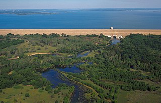
The Lewisville Lake Toll Bridge (LLTB) is a 1.7 mile (2.7km) tied arch bridge crossing Lewisville Lake in Denton County, Texas, USA. The North Texas Tollway Authority (NTTA) worked cooperatively with Denton County to plan and design a toll bridge across the northwestern arm of Lewisville Lake. The four-lane toll bridge connects Swisher Road in Lake Dallas to Eldorado Parkway in Little Elm, Texas. The Lewisville Lake Corridor is approximately 13.8 miles long and is divided into eight sections constructed by Denton County, NTTA, TxDOT, Little Elm, and Frisco, Texas. The bridge is the second longest bridge in the North Texas area, behind the Texas State Highway 66 bridge over Lake Ray Hubbard between Rowlett and Rockwall approximately 30 miles to the southeast.
The Trinity Parkway was a proposed six-lane toll road in Dallas, Texas (USA) to run from the State Highway 183/Interstate 35E interchange to U.S. Highway 175/Interstate 45. The Dallas City Council voted 14–1 in 2007 to support a parkway inside the eastern levee of the Trinity River. Dallas City Council had recommended that a "context-sensitive design" be used for the parkway.
There are approximately 25 current toll roads in the state of Texas. Toll roads are more common in Texas than in many other U.S. states, since the relatively low revenues from the state's gasoline tax limits highway planners' means to fund the construction and operation of highways.
The Sam Rayburn Tollway is a tollway operated by the North Texas Tollway Authority that runs from Grapevine to McKinney. Its frontage road are signed State Highway 121.
Spur 303 is a state highway between Interstate 820 in Fort Worth, and Duncanville Road in Dallas. At 17.4 miles (28.0 km) in length, it is Texas' longest highway spur.
