
Lillooet, formerly Cayoosh Flat, is a community on the Fraser River in British Columbia, Canada, about 240 kilometres (150 mi) up the British Columbia Railway line from Vancouver. Situated at an intersection of deep gorges in the lee of the Coast Mountains, it has a dry climate with an average of 329.5 millimetres (13 in) of precipitation being recorded annually. Lillooet has a long growing season, and once had prolific market gardens and orchard produce. It often vies with Lytton and Osoyoos for the title of "Canada's Hot Spot" on a daily basis in summer.
Yale is an unincorporated town in the Canadian province of British Columbia.
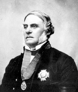
Sir James Douglas, was a Canadian fur trader and politician who became the first Governor of the Colony of British Columbia. He is often credited as "The Father of British Columbia".
British Columbia gold rushes were important episodes in the history and settlement of European, Canadian and Chinese peoples in western Canada.

The Cariboo Road was a project initiated in 1860 by the Governor of the Colony of British Columbia, James Douglas. It involved a feat of engineering stretching from Fort Yale to Barkerville in the Canadian province of British Columbia through extremely hazardous canyon territory in the interior of British Columbia.

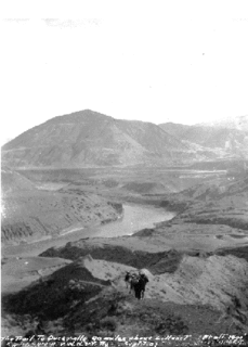
The Fraser Canyon is a major landform of the Fraser River where it descends rapidly through narrow rock gorges in the Coast Mountains en route from the Interior Plateau of British Columbia to the Fraser Valley. Colloquially, the term "Fraser Canyon" is often used to include the Thompson Canyon from Lytton to Ashcroft, since they form the same highway route which most people are familiar with, although it is actually reckoned to begin above Williams Lake, British Columbia at Soda Creek Canyon near the town of the same name.

The Cariboo Gold Rush was a gold rush in the Colony of British Columbia, which earlier joined the Canadian province of British Columbia. The first gold discovery was made at Hills Bar in 1858, followed by more strikes in 1859 on the Horsefly River, and on Keithley Creek and Antler Creek in 1860. The actual rush did not begin until 1861, when these discoveries were widely publicized. By 1865, following the strikes along Williams Creek, the rush was in full swing.

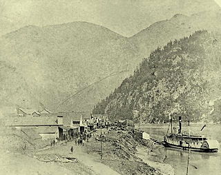
The Fraser Canyon Gold Rush, began in 1858 after gold was discovered on the Thompson River in British Columbia at its confluence with the Nicoamen River a few miles upstream from the Thompson's confluence with the Fraser River at present-day Lytton. The rush overtook the region around the discovery, and was centered on the Fraser Canyon from around Hope and Yale to Pavilion and Fountain, just north of Lillooet.
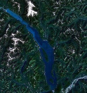
Harrison Lake is the largest lake in the southern Coast Mountains of Canada, being about 250 square kilometres (95 mi²) in area. It is about 60 km (37 mi) in length and at its widest almost 9 km (5.6 mi) across. Its southern end, at the resort community of Harrison Hot Springs, is c. 95 km east of downtown Vancouver. East of the lake are the Lillooet Ranges while to the west are the Douglas Ranges. The lake is the last of a series of large north-south glacial valleys tributary to the Fraser along its north bank east of Vancouver, British Columbia. The others to the west are the Chehalis, Stave, Alouette, Pitt, and Coquitlam Rivers.

The Douglas Road, a.k.a. the Lillooet Trail, Harrison Trail or Lakes Route, was a goldrush-era transportation route from the British Columbia Coast to the Interior. Over 30,000 men are reckoned to have travelled the route in, although by the end of the 1860s it was virtually abandoned due to the construction of the Cariboo Wagon Road, which bypassed the region.

Port Douglas, sometimes referred to simply as Douglas, is a remote community in British Columbia, Canada at east of the mouth of the Lillooet River, and at the head of Harrison Lake, which is the head of river navigation from the Strait of Georgia. Port Douglas was the second major settlement of any size on the British Columbia mainland during the Fraser Canyon Gold Rush. It came into being in 1858 when Governor Douglas ordered that it be laid out.

The Colony of British Columbia was a crown colony in British North America from 1858 until 1866. It was founded by the British Crown, who appointed James Douglas, then Governor of the neighbouring colony of Vancouver's Island as the Colony's first Governor. Richard Clement Moody was the Colony's first Chief Commissioner of Lands and Works. At its creation, it physically constituted approximately half the present day Canadian province of British Columbia, since it did not include the Colony of Vancouver Island, the vast regions north of the Nass and Finlay Rivers, the regions east of the Rocky Mountains, or any of the coastal islands. The Colony of the Queen Charlotte Islands and the Stikine Territory were merged with it in 1863, and it was amalgamated in 1866 with the Colony of Vancouver Island to form a new Colony of British Columbia.

The Okanagan Trail was an inland route to the Fraser Canyon Gold Rush from the Lower Columbia region of the Washington and Oregon Territories in 1858–1859. The route was essentially the same as that used by the Hudson's Bay Company fur brigades, following the Columbia River to the confluence of the Okanogan River, and then up that river's watercourse via Osoyoos, Skaha (Dog) and Okanagan Lakes, then using a pass via Monte Creek to Fort Kamloops, at the confluence of the North and South Thompson Rivers. The route then went west from there down the Thompson River either to the lower gold-bearing bars of the Fraser River between what is now Lytton, British Columbia and Yale, British Columbia, or via Hat Creek and Marble Canyon to the upper Fraser goldfields around present-day Lillooet, British Columbia. A shorter branch-route to the lower Thompson and lower Fraser Canyon diverged from the main route at the confluence of the Similkameen River and the Okanogan. Cayoosh and The Fountains are today's Lillooet, British Columbia and environs.
Soda Creek is a rural subdivision 38 km north of Williams Lake in British Columbia, Canada. Located on the east bank of the Fraser River, Soda Creek was originally the home of the Xat'sull First Nation. Soda Creek Indian Reserve No. 1 is located on the left (E) bank of the Fraser River, one mile south of the Soda Creek BCR (CN) station, 431.10 ha. 52°19′00″N122°16′00″W
The Old Cariboo Road is a reference to the original wagon road to the Cariboo gold fields in what is now the Canadian province of British Columbia. It should not be confused with the Cariboo Road, which was built slightly later and used a different route.
The River Trail was a main route for travel in the colonial era of what is now the Canadian province of British Columbia, running northwards along the Fraser River from to present day Lillooet to Big Bar, British Columbia and points beyond in the Cariboo District. The route was primarily in use during the Fraser Canyon Gold Rush and associated explorations by prospectors northwards in the search for gold in the Cariboo and Omineca Districts.
The Hudson's Bay Brigade Trail, sometimes referred to simply as the Brigade Trail, refers to one of two routes used by Hudson's Bay Company fur traders to transport furs, goods and supplies between coastal and Columbia District headquarters at Fort Vancouver and those in New Caledonia and also in Rupert's Land. Importantly the route was that used by the annual "Hudson's Bay Express", a shipment of the company books and profits to company headquarters.

Cayoosh Creek is a northeast-flowing tributary of the Seton River in the Canadian province of British Columbia. The name Cayoosh Creek remains on the bridge-sign crossing the stream on BC Highway 99 and continues in use locally to refer to the final reaches of the Seton River, formerly Seton Creek, which prior to the renaming ending at the confluence with Cayoosh Creek. The creek is the namesake of Cayoosh Creek Indian Reserve No. 1, one of the main Indian reserves of the Cayoose Creek Indian Band, which lies adjacent to what was renamed the Seton River without local consultation.

This article is about Steamboats of the Lower Fraser River and Harrison Lake. The first steamboat on the Fraser River was the SS Beaver which entered Pacific waters in 1835. It was an itinerant supply for the Hudson's Bay Company roving throughout the lower Columbia River in Oregon and around coastal Washington, British Columbia and southeastern Russian America (Alaska), long before those political entities came into being.
Fort Berens Winery, aka Fort Berens Estate Winery, is a winery and vineyard based in Lillooet, British Columbia, Canada. Located in East Lillooet, near the site of the never-built Hudson's Bay Company's Fort Berens, it is the first successful attempt at a commercial winery in the area in the 20th Century and has won numerous awards for its wines. It is the only commercial winery so far in the newly designated Lillooet wine region, though there are established local vinyards which are non-commercial and a history of wine cultivation at nearby Fountain. It was founded by Rolf de Bruin, who immigrated to Canada with his family in 2008 from the Netherlands with his wife Heleen Pannekoek and their family. They chose Lillooet over the Okanagan because land values there were a quarter what they were in the Okanagan, which is the centre of the BC wine industry. Though the winery's first commercial vintage was made from grapes and wine brought in from the Okanagan, their first bottles made from grapes grown only in Lillooet were opened on April 30, 2012. The winery first started operations in 2009.
