Coconino County is a county in the north-central part of the U.S. state of Arizona. Its population was 145,101 at the 2020 census. The county seat is Flagstaff. The county takes its name from Cohonino, a name applied to the Havasupai people. It is the second-largest county by area in the contiguous United States, behind San Bernardino County, California. It has 18,661 sq mi (48,300 km2), or 16.4% of Arizona's total area, and is larger than the nine smallest states in the U.S.

Mohave County is in the northwestern corner of the U.S. state of Arizona. As of the 2020 census, its population was 213,267. The county seat is Kingman, and the largest city is Lake Havasu City. It is the fifth largest county in the United States.

Yavapai County is near the center of the U.S. state of Arizona. As of the 2020 census, its population was 236,209, making it the fourth-most populous county in Arizona. The county seat is Prescott.

Camp Verde is a town in Yavapai County, Arizona, United States. As of the 2010 census, the population of the town is 10,873.

Dewey–Humboldt is a town in Yavapai County, Arizona, United States. The population of the town was 3,894 according to the 2010 census. The Dewey–Humboldt area was a census-designated place (CDP) at the 2000 census, at which time its population was 6,295.

Lake Montezuma is a census-designated place (CDP) in Yavapai County in the U.S. state of Arizona. The population was 5,111 at the 2020 census. The CDP includes the communities of Rimrock and McGuireville. Located along Interstate 17, it is 20 miles (32 km) south of Sedona and 8 miles (13 km) north of Camp Verde in central Arizona's Verde Valley.

Prescott is a city and the county seat of Yavapai County, Arizona, United States. As of 2020 Census, the city's population was 45,827.

Prescott Valley is a town located in Yavapai County, Arizona, United States, approximately 8 miles (13 km) east of Prescott. According to the 2020 United States Census, Prescott Valley has a population of 46,785 residents.

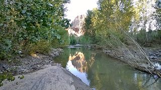
The Verde River is a major tributary of the Salt River in the U.S. state of Arizona. It is about 170 miles (270 km) long and carries a mean flow of 602 cubic feet per second (17.0 m3/s) at its mouth. It is one of the largest perennial streams in Arizona.
The Big Sandy River is both an intermittent and perennial stream in Mohave and La Paz counties in northwestern Arizona in the United States. It begins where Cottonwood Wash and Trout Creek converge in the Hualapai Indian Reservation east of U.S. Route 93 then flows past Wikieup south of Kingman. The Big Sandy River then passes the Signal Ghost Town Site, meanders through the Arrastra Mountain Wilderness, and joins the Santa Maria River in Southern Mohave County to form the Bill Williams River. The Bill Williams River then empties into Alamo Lake State Park. The Big Sandy River is 55.7 miles (89.6 km) long.

The Hualapai is a federally recognized Native American tribe in Arizona with about 2300 enrolled members. Approximately 1353 enrolled members reside on the Hualapai Reservation, which spans over three counties in Northern Arizona.
Arizona's 2nd congressional district is a congressional district located in the U.S. state of Arizona. The district is in the north eastern part of the state and includes Apache, Coconino, Gila, Navajo, and Yavapai counties in their entirety and portions of Graham, Maricopa, Mohave, and Pinal counties. The largest city in the district is Flagstaff.

Fort Whipple is a former United States (U.S.) Army post that was temporarily established at Del Rio Springs, north of present-day Chino Valley, Arizona, and later relocated to a permanent site near present-day Prescott, Arizona.
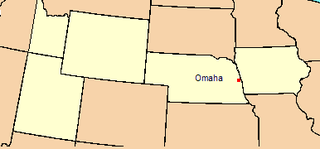
The Department of the Platte was a military administrative district established by the U.S. Army on March 5, 1866, with boundaries encompassing Iowa, Nebraska, Dakota Territory, Utah Territory and a small portion of Idaho. With headquarters in Omaha, the district commander oversaw the army's role initially along the Overland route to Salt Lake City, then later the construction route of the Union Pacific Railroad. The district also included the Montana road through eastern Wyoming. The district was discontinued when the Army's command was reorganized in 1898.
District of Arizona was a subordinate district of the Department of New Mexico territory created on August 30, 1862 and transferred to the Department of the Pacific in March 1865.
The 4th Arizona Territorial Legislative Assembly was a session of the Arizona Territorial Legislature which ran from September 4, 1867, till October 7, 1867, in Prescott, Arizona. Among the sessions accomplishments were establishment of the territory's first "permanent" capital and creation of the territory's first school district.

The Hualapai War, or Walapai War, was an armed conflict fought from 1865 to 1870 between the Hualapai native Americans and the United States in Arizona Territory. The Yavapai also participated on the side of the Hualapai and Mohave scouts were employed by the United States Army. Following the death of the prominent Yavapai leader Anasa in April 1865, the natives began raiding American settlements which provoked a response by the United States Army forces stationed in the area. By the spring of 1869 disease forced the majority of the Hualapais to surrender though some skirmishing continued for almost two more years.
The District of New Mexico was a military district of the United States Army in the Territory of New Mexico that existed from 1865 to 1890. The District of Arizona and the District of New Mexico replaced the Department of New Mexico from June 27, 1865.