Mahim (Marathi: माहिम) is a neighbourhood in Mumbai, Maharashtra, India. The Mahim Junction railway station on the Western Railway and Harbour Railway of the Mumbai Suburban Railway network is the last station of the city, as neighboring Bandra comes in Mumbai Suburb. Mahim is an ethnically and religiously diverse town and has a Hindu temple, church, mosque and Parsi fire-temple existing within a few meters of each other. The town has a large Rich and Upper Middle class Marathi population.
Mahabaleshwar is a small town and a municipal council in Satara district, Maharashtra, India. It is a place of pilgrimage for Hindus because the Krishna River has its origin here. The British colonial rulers developed the town as a hill station, and it served as the summer capital of the Bombay Presidency during the British Raj.

Vasai is a historical place and city located in Palghar district; which was partitioned out of the Thana district in 2014. It also forms a part of Vasai-Virar twin cities in the Konkan division, Maharashtra, India, and comes under the Police Jurisdiction of Mira-Bhayander, Vasai-Virar Police Commissionerate.

The Worli Fort is a fort in Worli, Mumbai, India. Though often incorrectly assumed to have been built by the Portuguese, the fort was built by the British around 1675 on Worli Hill. Worli Fort overlooked Mahim Bay at a time when the city comprised just seven islands and was used as a lookout for enemy ships.

The Bombay East Indians, also called East Indian Catholics or simply East Indians, are an ethno-religious Indian Christian community native to the Seven Islands of Bombay and the neighbouring Mumbai Metropolitan Area of the Konkan division, along the western coast of India.

Fort is a business and art district in the city of Mumbai, Maharashtra, India. The area gets its name from the defensive fort, Fort George, built by the British East India Company around Bombay Castle.

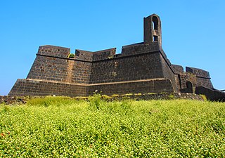
Fort Vasai is a ruined fort of the town of Vasai (Bassein), Konkan Division, Maharashtra, India. The structure was formally christened as the Fort of St Sebastian in the Indo-Portuguese era. The fort is a monument of national importance and is protected by the Archaeological Survey of India.

The Sewri Fort is a fort in Mumbai built by the British at Sewri. Built in 1680, fort served as a watch tower, atop a quarried hill overlooking the Mumbai harbour.
The Mazagaon Fort was a British fort in Mazagaon, Bombay, in the Indian state of Maharashtra, built around 1680. The fort was razed by the Muslim Koli general, Yakut Khan in June 1690. The fort was located at the present-day Joseph Baptista Gardens, atop Bhandarwada Hill outside the Dockyard Road railway station.

The Dongri Fort or the Dongri Hill Fort, locally known as the Janjire Dhavari Fort, is a fort in Mumbai, India. It is located in the Dongri area. It came under Maratha rule in 1739. Since then the locals and the church have been looking after the maintenance of the Fort, which was once repaired. Every year, during the month of October, the feast of Our Lady of Fatima is celebrated there. Many People from far off villages come to offer their prayers there. One can take a 360 degree view of the surroundings from this fort, with the Arabian Sea at the West, the Vasai Fort at the North, the Borivali National Park at the East, and the Essel World and Water Kingdom at the South.

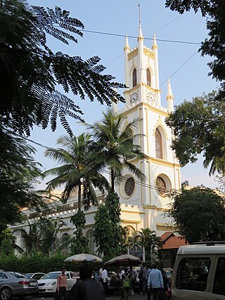
St. Thomas Cathedral, Mumbai, is the 300-year old cathedral church of the Anglican Diocese of Mumbai of the Church of North India. It is named in honour of Saint Thomas the Apostle, who is believed to have first brought Christianity to India. The cathedral is located in Horniman Circle, the historic centre of Mumbai. It is in close proximity to famous Mumbai landmarks such as Flora Fountain and Bombay House. It is the oldest church in Mumbai The Cathedral and John Connon School is run by the cathedral.

Bombay Castle is one of the oldest defensive structures built in the city of Mumbai. The current castle is a structure built by the British on the site of the Manor House built by a Portuguese nobleman Garcia de Orta. Orta had leased the island of Bombay from the King of Portugal between 1554 and 1570.

Kolaba Fort located at Alibag beach is an old fortified maritime base in Alibag, Konkan, India. It is situated in the sea at a distance of 1–2 km from the shores of Alibag, 35 km south of Mumbai, in the Konkan region of Maharashtra, India. It is a popular tourist destination and a protected monument.
Indigenous tribals have inhabited Mumbai (Bombay) since the Stone Age. The Kolis and Aagri were the earliest known settlers of the islands. Between the 2nd century BCE and 10th century CE, the islands came under the control of successive indigenous dynasties: the Satavahanas, Abhiras, Vakatakas, Kalachuris, Konkan Mauryas, Chalukyas, Rashtrakutas, Silharas & Cholas.

Bombay, also called Bom Bahia or Bom Baim in Indo-Portuguese creole, Mumbai in the local language; is the financial and commercial capital of India and one of the most populous cities in the world. It's also the cosmopolitan city centre of the Greater Bombay Metropolitan Area, and the cultural base of the Bollywood film industry. At the time of arrival of the Portuguese Armadas, Bombay was an archipelago of seven islands. Between the third century BCE and 1348, the islands came under the control of successive Hindu dynasties. The Delhi Sultanate had been ruling the area along with Chaul, New Bombay (Thana) & Damaon; with the local administration at Bassein (Vasai) since the raids of Malik Kafur in the Konkan region and across the Indian subcontinent. This territory in North Konkan along with the Bombay islands were later taken over by the Sultan of Guzerat from 1391 to 1534, when he had declared the end of the suzerainty to Delhi, after the Timurid invasion of it. Growing apprehensive of the power of the Moghal emperor Humayun, Sultan Bahadur Shah of Gujarat was obliged to sign the Treaty of Bassein on 23 December 1534; according to which, the Seven Islands of Bombay, Fort San Sebastian of Bassein in strategic town of Bassein (Vasai), and its dependencies were offered to the Portuguese East Indies. The places were only later officially surrendered on 25 October 1535, by the Sultan of Guzerat.

Bombay, also called Bom baim in Portuguese, is the financial and commercial capital of India and one of the most populous cities in the world.
Underi is a fortified island near the mouth of Mumbai harbour south of Prong's Lighthouse. It is a companion fort to Khanderi and currently lies in Raigad district, Maharashtra. These islands of Khanderi and Underi served as one of the landmarks for ships entering Mumbai harbour. Underi is smaller than Khanderi.
Dharavi Island is an island situated at the mouth of Vasai Creek on the western side of Salsette Island, within the city of Mumbai, India. Dharavi Island comprises six villages, Dongri, Uttan, Pali, Chowk, Gorai, and Manori.


