
The Sacramento River is the principal river of Northern California in the United States and is the largest river in California. Rising in the Klamath Mountains, the river flows south for 400 miles (640 km) before reaching the Sacramento–San Joaquin River Delta and San Francisco Bay. The river drains about 26,500 square miles (69,000 km2) in 19 California counties, mostly within the fertile agricultural region bounded by the Coast Ranges and Sierra Nevada known as the Sacramento Valley, but also extending as far as the volcanic plateaus of Northeastern California. Historically, its watershed has reached as far north as south-central Oregon where the now, primarily, endorheic (closed) Goose Lake rarely experiences southerly outflow into the Pit River, the most northerly tributary of the Sacramento.

Fort Crawford was an outpost of the United States Army located in Prairie du Chien, Wisconsin, during the 19th century.

Fort Kearny was a historic outpost of the United States Army founded in 1848 in the western U.S. during the middle and late 19th century. The fort was named after Col. and later General Stephen Watts Kearny. The outpost was located along the Oregon Trail near Kearney, Nebraska. The town of Kearney took its name from the fort. The "e" was added to Kearny by postmen who consistently misspelled the town name. A portion of the original site is preserved as Fort Kearny State Historical Park by the Nebraska Game and Parks Commission.

Clear Creek is a tributary of the upper Sacramento River in northern California.

Fort Gibson is a historic military site next to the modern city of Fort Gibson, in Muskogee County Oklahoma. It guarded the American frontier in Indian Territory from 1824 to 1888. When it was constructed, the fort was farther west than any other military post in the United States. It formed part of the north–south chain of forts that was intended to maintain peace on the frontier of the American West and to protect the southwestern border of the Louisiana Purchase. The fort succeeded in its peacekeeping mission for more than 50 years, as no massacres or battles occurred there.

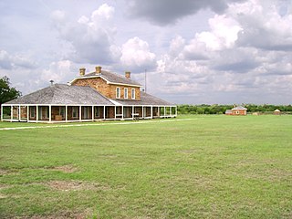
Fort Inge was a frontier fort in Uvalde County, Texas, United States.
Fort Richardson was a United States Army installation located in present-day Jacksboro, Texas. Named in honor of Union General Israel B. Richardson, who died in the Battle of Antietam during the American Civil War, it was active from 1867 to 1878. Today, the site, with a few surviving buildings, is called Fort Richardson State Park, Historic Site and Lost Creek Reservoir State Trailway. It was designated a National Historic Landmark in 1963 for its role in securing the state's northern frontier in the post-Civil War era.
Fort Quitman was a United States Army installation on the Rio Grande in Texas, United States, south of present-day Sierra Blanca, 20 miles southeast of McNary in southern Hudspeth County. The fort, now a ghost town, was named for former Mississippi Governor John A. Quitman, who served as a major general under Zachary Taylor during the Mexican–American War.

Fort Mason was established on July 6, 1851, in present-day Mason County, Texas. It was named in honor of George Thomson Mason, a United States Army second lieutenant killed in the Thornton Affair during the Mexican–American War near Brownsville, April 25, 1846. At various times from 1856 to 1861, this was the home fort for Albert Sidney Johnston, George H. Thomas, Earl Van Dorn, and Robert E. Lee. The fort was abandoned by the military in the 1870s, and restored by a group of local citizens in 1975. Visitors can tour the reproduction officers' quarters at the Fort Mason Museum.
Milton Faver was a pioneering cattle rancher in Presidio County, Texas, the preeminent cattle baron of the Big Bend in the nineteenth century, and one of the most important individual contributors to Big Bend history. Also known in his time by the honorary title, don Melitón, he founded Cibolo Creek Ranch halfway between Marfa and Presidio, Texas in 1857. He was one of the earliest Texas trail drivers, driving his cattle to market in New Orleans in the 1850s and to other markets later. Although his birthplace is not known with certainty, he was most likely born and raised in Missouri around 1822. Local lore contends that, while in his teens, he fought a duel and fled south, believing he had killed his opponent.
Palm Spring Station is a former Butterfield Overland Mail stagecoach station located at Palm Spring in San Diego County, California. This station built in 1858 by division agent, Warren F. Hall is commemorated by California State Historical Marker Number 639 Palm Spring.

Fort Dale was a stockade fort built in present-day Butler County, Alabama by Alabama Territory settlers. The fort was constructed in response to Creek Indian attacks on settlers in the surrounding area.

New San Diego Barracks also called San Diego Barracks, was a United States Army quartermaster supply depot with barracks, warehouses, stables, and a hay house set up by Captain Nathaniel Lyon, with the 2nd U.S. Infantry, in 1850 at New San Diego. The depot had a wharf on San Diego Bay to load and unload supplies. The depot supported Southern California forts, stations and posts with military supplies. New San Diego Barracks was renamed to San Diego Barracks by General Orders No. 2, Military Division of the Pacific, San Francisco on April 5, 1879. The land for the depot was sold to the US Army by Gray, Johns, George F. Hooper, Davis and wife, Jose Aguirre and wife, and the heirs of Miguel de Pedrorena on September 12, 1850. The Great Flood of 1862 turned the depot into a sea of water and mud. One of the forts that San Diego Barracks supported was Fort Yuma used from 1851 to 1883. San Diego Barracks was built in what was called at the time New San Diego, on San Diego Bay, south of Pueblo de San Diego founded in 1835. New San Diego was built up by William Heath Davis in the early 1850s, in that he called New Town San Diego.

Bell's Bridge is a historical site in Redding, California in Shasta County. Battle Rock site is a California Historical Landmark No. 519 listed onMay 28, 1954.

Dersch Homestead is a historical site in Anderson, California in Shasta County. Dersch Homestead site is a California Historical Landmark No. 120 listed on March 31, 1933.

Reading Adobe is a historical site in Cottonwood, California in Shasta County. Pioneer Baby's Grave is a California Historical Landmark No. 10 listed on June 1, 1932. Reading Adobe is listed on the National Register of Historic Places listings in Shasta County, California, listed July 14, 1971 as #71000194.

Reading's Bar is a historical site in Redding, California in Shasta County. Reading's Bar is a California Historical Landmark No. 32 listed on August 1, 1932. Reading's Bar was named after Major Pierson Barton Reading, who discovered gold on the Clear Creek bar in May 1848, starting a California Gold Rush in the surrounding area. Later he found gold on a sandbar on the Trinity River that started the Trinity Alps Gold Rush. Reading's gold discovery was a major part of the California Gold Rush and news of the find created a rush of gold prospecting in Northern California, well north of the better-known gold fields of the Sierra Nevada foothills.

Piety Hill, California is a historical site on Cloverdale Road in Shasta County, near Igo, California. The city was founded in 1849 as part of the California Gold Rush. Like many Gold Rush camps that became a town, the town grew quickly from a few miners to a town of 1,500. Near Piety Hill was Chinatown of 600 that mined and farmed. The large scale Hardscrabble mine opened in 1853. Mining need lot of water and the Dry Creek Tunnel and Fluming Company both ran a water system, with a two-mile ditch, to the town and mines nearby, built with Chinese labor. In 1866 the Hardscrabble's hydraulic mining run off threatened the town. Many fed to nearby Igo. Hydraulic mining was outlawed in 1884 in the anti-debris act. The town ended in the 1920 when the last two Chinese residents died. The Dry Creek Tunnel and Fluming Company water right were transferred to the Happy Valley Land and Water Company that serves the Happy Valley area. There are no remains of this town. The Piety Hill Loop is a 4.1-mile loop trail near Igo. A historical was place near the form town by the Ono Grange #445, E Clampus Vitus, Trintarianus Chapter # 62 and the Department of the Interior and Bureau of Land Management.

Tower House, California was a mining town in Shasta County. The mining District of Tower House was placed on the National Register of Historic Places on July 2, 1973, as #73000257 as the Tower House Historic District. The Tower House Historic District is located just west of the Whiskeytown National Recreation Area. The town started as a California Gold Rush camp. The town is named after Levi Tower, who built the Tower House Hotel and helped establish the town.
Southern's Stage Station was built in 1859 by Simeon Fisher Southern. The Southern's Stage Station site is on 9010 Mears Ridge Road, south of Castella, California in Shasta County. The Southern's Stage Station is a California Historical Landmark No. 33 listed on August 1, 1932. Simeon Fisher Southern and his Sarah Southern operated the Stagecoach Station wife Southern's Stage Station and Southern Hotel were log cabin building built in 1859. Travelers on the stagecoach or riding through could stop for rest and food for the 50 years this station operated till 1909. The town was called Hazel Creek, California, but change to Sims, California in 1871 as Southern's Stage Station and store was the center of the town.


