Related Research Articles

Trempealeau County is a county in the U.S. state of Wisconsin. As of the 2020 census, the population was 30,760. Its county seat is Whitehall.

Pierre Gaultier de Varennes, sieur de La Vérendrye was a French Canadian military officer, fur trader, and explorer. In the 1730s, he and his four sons explored the area west of Lake Superior and established trading posts there. They were part of a process that added Western Canada to the original New France territory that was centred along the Saint Lawrence basin.

Prairie du Chien is a city in and the county seat of Crawford County, Wisconsin, United States. The population was 5,506 at the 2020 census. Often called Wisconsin's second-oldest city, Prairie du Chien was established as a European settlement by French voyageurs in the late 17th century. Its settlement date of June 17, 1673, makes it the fourth colonial settlement by European settlers in the Midwestern United States, after Green Bay, Wisconsin, Sault Ste. Marie, Michigan, and St. Ignace, Michigan. The city has many sites showing its rich history in the region.
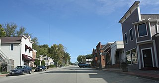
Trempealeau is a village located along the Mississippi River in Trempealeau County in the U.S. state of Wisconsin. The population was 1,843 at the 2020 census. The village is surrounded by the Town of Trempealeau.

The Illinois Country, also referred to as Upper Louisiana, was a vast region of New France claimed in the 1600s that later fell under Spanish and British control before becoming what is now part of the Midwestern United States. While the area claimed included the entire Upper Mississippi River watershed, French colonial settlement was concentrated along the Mississippi and Illinois Rivers in what is now the U.S. states of Illinois and Missouri, with outposts on the Wabash River in Indiana. Explored in 1673 from Green Bay to the Arkansas River by the Canadien expedition of Louis Jolliet and Jacques Marquette, the area was claimed by France. It was settled primarily from the Pays d'en Haut in the context of the fur trade, and in the establishment of missions from Canada by French Catholic religious orders. Over time, the fur trade took some French to the far reaches of the Rocky Mountains, especially along the branches of the broad Missouri River valley. The "Illinois" in the territory's name is a reference to the Illinois Confederation, a group of related Algonquian native peoples.

The Driftless Area, also known as Bluff Country and the Paleozoic Plateau, is a topographical and cultural region in the Midwestern United States that comprises southwestern Wisconsin, southeastern Minnesota, northeastern Iowa, and the extreme northwestern corner of Illinois. The Driftless Area is a USDA Level III Ecoregion: Ecoregion 52. The Driftless Area takes up a large portion of the Upper Midwest forest–savanna transition. The eastern section of the Driftless Area in Minnesota is called the Blufflands, due to the steep bluffs and cliffs around the river valleys. The western half is known as the Rochester Plateau, which is flatter than the Blufflands. The Coulee Region is the southwestern part of the Driftless Area in Wisconsin. It is named for its numerous ravines.
Louisiana or French Louisiana was an administrative district of New France. In 1682 the French explorer René-Robert Cavelier, Sieur de la Salle erected a cross near the mouth of the Mississippi River and claimed the whole of the drainage basin of the Mississippi River in the name of King Louis XIV, naming it "Louisiana". This land area stretched from the Great Lakes to the Gulf of Mexico and from the Appalachian Mountains to the Rocky Mountains. The area was under French control from 1682 to 1762 and in part from 1801 (nominally) to 1803.
Fort de Buade was a French fort in the present U.S. state of Michigan's Upper Peninsula across the Straits of Mackinac from the northern tip of lower Michigan's "mitten". It was garrisoned between 1683 and 1701. The city of St. Ignace developed at the site, which also had the historic St. Ignace Mission founded by Jesuits. The fort was named after New France's governor at the time, Louis de Buade de Frontenac.
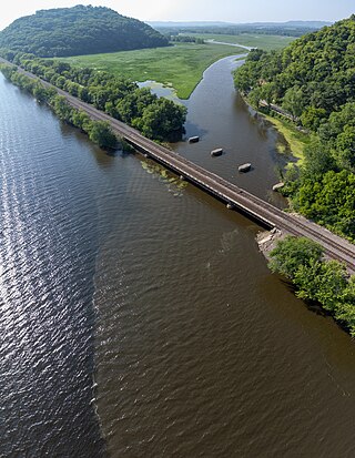
The Trempealeau River is an 81.5-mile-long (131.2 km) tributary of the Mississippi River in the Driftless Area of western Wisconsin in the United States.

The Black River is a river in west-central Wisconsin and tributary of the Mississippi River. The river is approximately 190 miles (310 km) long. During the 19th century, pine logs were rafted down the Black, heading for sawmills at La Crosse and points beyond.

Nicolas Perrot, a French explorer, fur trader, and diplomat, was one of the first European men to travel in the Upper Mississippi Valley, in what is now Wisconsin and Minnesota.

Perrot State Park is a state park in Wisconsin's Driftless Area at the confluence of the Trempealeau and Mississippi rivers. The 1,270-acre (514 ha) park features views of steep limestone bluffs and the river valleys. It has observation platforms for watching wildlife, including the variety of birds which inhabit or migrate through the park. Hiking trails and camping are available. Mountain bike trails penetrate deep inside the park.
The Fox Wars were two conflicts between the French and the Fox people that lived in the Great Lakes region from 1712 to 1733. These territories are known today as the states of Michigan and Wisconsin in the United States. The Wars exemplified colonial warfare in the transitional space of New France, occurring within the complex system of alliances and enmities with native peoples and colonial plans for expansion.
René Godefroy, Sieur de Linctot de Tonnancour was an early Canadien settler. He was from an early, prominent, French Canadian family.

The Pays d'en Haut was a territory of New France covering the regions of North America located west of Montreal. The vast territory included most of the Great Lakes region, expanding west and south over time into the North American continent as the French had explored. The Pays d'en Haut was established in 1610 and depended on the colony of Canada until 1763, when the Treaty of Paris ended New France, and both were ceded to the British as the Province of Quebec.

Fort Saint Antoine was a French fort on Lake Pepin in present-day Wisconsin founded in 1686 by explorer and fur trader Nicholas Perrot and his expedition of Canadiens. They had come to the region to begin trading with Native American tribes of the area.
Fort La Baye was a French military post at La Baye, originally built in 1684, remodeled in 1717, and occupied until 1760.

Trempealeau Mountain State Natural Area is a Wisconsin Department of Natural Resources-designated State Natural Area consisting of a 425-foot conical rock mound surrounded on three sides by the Mississippi and Trempealeau Rivers. It is one of only 3 solid rock islands along the entire Mississippi River.

The Great River State Trail is a 24-mile (39 km) rail trail between Onalaska and Marshland, Wisconsin. It is designed for foot, bicycle, equestrian or light motorized traffic. It is designated as a multiuse trail, offering recreational access to the routes, and is open to the public.
The French Louisianians, also known as Louisiana French, are Latin French people native to the states that were established out of French Louisiana. They are commonly referred to as French Creoles. Today, the most famous Louisiana French groups are the Alabama Creoles, Louisiana Creoles, and the Missouri French.
References
- ↑ "Nicolas Perrot: Early Wisconsinite". www.uwgb.edu. Archived from the original on 2000-05-18.
44°00′53″N91°28′26″W / 44.01473°N 91.47391°W
| | This military base or fortification article is a stub. You can help Wikipedia by expanding it. |