Fortaleza San Felipe

Last updated
Museo de la Fortaleza San Felipe
Fortaleza de San Felipe DR 1.jpg
Fortaleza San Felipe
Established1965
Opened to the Public in 1983
Location Puerto Plata, Dominican Republic
Coordinates 19°48′15″N70°41′45″W / 19.8041°N 70.695925°W / 19.8041; -70.695925
Type History museum

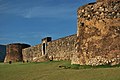
The Fortaleza San Felipe is a historic Spanish fortress located in the north of the Dominican Republic in the province of Puerto Plata. Also known as El Morro de San Felipe, it was used to protect the City of Puerto Plata from foreign invaders, pirates, and privateers. [1] It is located on a hill at the Puntilla del Malecón (the "seawall point"), overlooking the entrance to the city's seaport.

Contents

The fort's construction was commissioned in 1564 and completed in 1577. [2] [3] It was named for King Felipe II of Spain. [4] The fort is one of the oldest European structures in the Caribbean, [5] [6] and is the only remnant of the 16th century in Puerto Plata. [7]

Today, the Fortaleza San Felipe serves as a museum [8] [9] showcasing the important role it has played in the history of Puerto Plata and the Dominican Republic. The fortress houses military artifacts from the 18th and 19th centuries. [8]

History

In 1564 the Spanish commissioned the construction of a fort in Puerto Plata, under the direction of Francisco Ceballos. [10] After Ceballos' death in 1572, construction was taken over by Don Rengifo de Angulo. [2] The fort's construction was completed in 1577. [2] It was named for the King of Spain, Felipe II. [4]

The fort was strategically constructed on a hill overlooking the Atlantic Ocean and entrance to the city's harbor: the Port of Puerto Plata. The fort's purpose was to defend the island's north coast from British and Dutch invaders, as well as from pirate attacks and pillaging. [11]

Over the centuries, the fort was the site of battles, captures, and occupations. In 1659, the fort was temporarily captured by buccaneers. [6] In 1800, the fortress was the scene of one of the few land battles in the Quasi War, against the United States. Specifically, the Battle of Puerto Plata Harbor in May 1800 saw American forces overwhelm both the French and Spanish forces. In 1863, the Spanish took refuge in the Fortaleza de San Felipe when the city was attacked by Dominican patriots on August 27. [12] The fort was captured and occupied by U.S. naval forces in 1916, at the start of the United States occupation of the Dominican Republic that lasted from 1916 to 1924. [13]

The Fortaleza San Felipe was used as a prison multiple times throughout its history, including during the dictatorship of Rafael Trujillo. [11] [14] It was where President Pedro Santana jailed one of the Dominican Republic's founding fathers, Juan Pablo Duarte. During Trujillo's rule, it was where the husbands of the Mirabal sisters were jailed. [14] [15]

The fortress was converted into a museum in 1965. It underwent a major renovation in 1972, and was officially opened to public in 1983. [16] [17] Today, the fortress is the only remnant of the 16th century in Puerto Plata. Other historic areas were destroyed in battles or fires during the War of Restoration. [7]

Related Research Articles

<span class="mw-page-title-main">Dominican Republic</span> Country in the Caribbean

The Dominican Republic is a country on the island of Hispaniola in the Greater Antilles archipelago of the Caribbean Sea, bordered by the Atlantic Ocean to the north. It occupies the eastern five-eighths of the island, which it shares with Haiti, making Hispaniola one of only two Caribbean islands, along with Saint Martin, that is shared by two sovereign states. It is the second-largest nation in the Antilles by area at 48,671 square kilometers (18,792 sq mi), and second-largest by population, with approximately 11.4 million people in 2024, of whom approximately 3.6 million live in the metropolitan area of Santo Domingo, the capital city.

<span class="mw-page-title-main">San Juan de Ulúa</span> Historic fortress off the coast of Veracruz, Mexico

San Juan de Ulúa, now known as Castle of San Juan de Ulúa, is a large complex of fortresses, prisons and one former palace on an island of the same name in the Gulf of Mexico overlooking the seaport of Veracruz, Mexico. Juan de Grijalva's 1518 expedition named the island. On March 30, 1519, Hernan Cortés met with Tendile and Pitalpitoque, emissaries from Moctezuma II's Aztec Empire.

<span class="mw-page-title-main">Culture of the Dominican Republic</span> Overview of the culture of Dominican Republic

The culture of the Dominican Republic is a diverse mixture of different influences from around the world. The Dominican people and their customs have origins consisting predominantly in a European cultural basis, with native Taíno and African influences.

<span class="mw-page-title-main">Castillo San Felipe del Morro</span> Large fortress and citadel in San Juan, Puerto Rico

Castillo San Felipe del Morro, commonly known as El Morro(The Promontory), is a large fortress and citadel in the historic district of Old San Juan, Puerto Rico. Commissioned by Charles I of Spain in 1539, it was first built as a fortified tower in honor of Philip II, who oversaw its expansion into a hornwork fort by 1595. Over the next 200 years, especially in the reign of Charles III, El Morro continued to be developed to reach its current form in 1787. Rising 140 ft from the Atlantic shoreline with 18 to 25 ft thick walls, it stands on a steep, rocky headland promontory on San Juan Islet guarding the entry to San Juan Bay, the harbor of Old San Juan. El Morro, alongside La Fortaleza, San Cristóbal, El Cañuelo, and other forts part of the Walls of Old San Juan, protected strategically and militarily important Old San Juan, La Llave de las Indias , from invasion by competing world powers during the Age of Sail.

<span class="mw-page-title-main">Castillo San Cristóbal (San Juan)</span> Fortress in San Juan, Puerto Rico

Castillo San Cristóbal is a fortress in San Juan, Puerto Rico. It was built by the Spanish to protect against land-based attacks on the historic city of Old San Juan. It is part of San Juan National Historic Site.

<span class="mw-page-title-main">Old San Juan</span> Historic district of San Juan, Puerto Rico

Old San Juan is a historic district located at the "northwest triangle" of the islet of San Juan in San Juan. Its area roughly correlates to the Ballajá, Catedral, Marina, Mercado, San Cristóbal, and San Francisco sub-barrios (sub-districts) of barrio San Juan Antiguo in the municipality of San Juan, Puerto Rico. Old San Juan is the oldest settlement within Puerto Rico and the historic colonial district of the city of San Juan. This historic district is a National Historic Landmark District named Zona Histórica de San Juan and is listed on the United States National Register of Historic Places as the Old San Juan Historic District. Several historical buildings and structures, particularly La Fortaleza, the city walls, and El Morro and San Cristóbal castles, have been inscribed in the UNESCO World Heritage Site list since 1983. Historically the mixed-use commercial and residential real estate in the main streets of Calle Cristo and Calle Fortaleza from Calle Tanca to the Governor’s Mansion is the most valuable in the area and it has kept its value and increased steadily through several years despite the past economic turmoils.

<span class="mw-page-title-main">Santiago de los Caballeros</span> City in Santiago, Dominican Republic

Santiago de los Caballeros, often shortened to Santiago, is the second-largest city in the Dominican Republic and the fourth-largest city in the Caribbean by population. It is the capital of Santiago Province and the largest major metropolis in the Cibao region of the country. Santiago is the largest Caribbean city that is not a capital city, and it is also the largest non-coastal metropolis in the Caribbean islands. The city has a total population of 771,748 inhabitants (2022). Santiago is located approximately 155 km (96 mi) northwest of the capital Santo Domingo with an average altitude of 178 m (584 ft).

<span class="mw-page-title-main">San Juan National Historic Site</span> U.S. national park site in Puerto Rico

San Juan National Historic Site in the Old San Juan section of San Juan, Puerto Rico, is a National Park Service-managed historic site which preserves and interprets the Spanish colonial-era fortification system of the city of San Juan, and features structures such as the San Felipe del Morro and San Cristóbal fortresses. This fortification system is the oldest European construction under United States jurisdiction and one of the oldest in the New World. This national historic site, together with La Fortaleza, have been designated a UNESCO World Heritage Site since 1983.

<span class="mw-page-title-main">Fortín San Juan de la Cruz</span> Fortress in Palo Seco, Toa Baja, Puerto Rico

Fortín San Juan de la Cruz, most commonly known as El Cañuelo, was built on Isla de Cabras in the Palo Seco barrio of the municipality of Toa Baja, at the western end of the entrance to San Juan Bay, in Puerto Rico. The square coastal fort has massive sandstone walls that date back to the 1630s. Although the U.S. Navy bombarded the fort in 1898, the fort survived. Today the fort is part of the San Juan National Historic Site, which is listed as a UNESCO World Heritage Site and on the National Register of Historic Places. The fort is not open to visitors, but it can be viewed from its exterior.

<span class="mw-page-title-main">Puerto Plata, Dominican Republic</span> City in Puerto Plata, Dominican Republic

Puerto Plata, officially known as San Felipe de Puerto Plata, is a major coastal city in the Dominican Republic, and capital of the province of Puerto Plata. The city is a major trading port. Puerto Plata has resorts such as Playa Dorada and Costa Dorada, which are located east of the city proper. There are 100,000 hotel beds in the city. The first aerial tramway of the Caribbean is located in Puerto Plata, in which visitors can ride up to the Pico Isabel de Torres, a 793-meter (2600-foot) high mountain within the city.

Fort San Felipe may refer to:

<span class="mw-page-title-main">Ciudad Colonial (Santo Domingo)</span> Historic district in Distrito Nacional, Dominican Republic

Ciudad Colonial is the historic central neighborhood of the Dominican Republic's capital Santo Domingo. It is the oldest continuously inhabited European-established settlement in the Americas. The area has been declared a World Heritage Site by UNESCO. It is also known as Zona Colonial or more colloquially as "La Zona".

<span class="mw-page-title-main">Fortaleza Ozama</span> UNESCO World Heritage Site in Santo Domingo, Dominican Republic

The Ozama Fortress, also formerly known as the city wall's Homage tower. It is one of the surviving sections of the Walls of Santo Domingo, which is recognized by UNESCO as being the oldest military construction of European origin in the Americas. It was built between 1502-1508 by the Spanish at the entrance to Santo Domingo's Ciudad Colonial, Dominican Republic, and overlooking the Ozama River. Named after this river, the castle, also referred to as "La Fortaleza" or "The Fortress". It was declared by UNESCO as a World Heritage Site, together with the other historical monuments of the Ciudad Colonial.

<span class="mw-page-title-main">Battle of Puerto Plata Harbor</span>

The Battle of Puerto Plata Harbor took place in 1800 with France and Spain on one side, and the United States on the other, during the undeclared Quasi-War officially between the French First Republic and the United States.

<span class="mw-page-title-main">Port of Puerto Plata</span>

El Port of Puerto Plata is found in San Felipe de Puerto Plata, in Dominican Republic. This is the main port on the north coast and is currently used for cargo operations. In December 2021, the new Taino Bay tourist and cargo terminal was inaugurated.

<span class="mw-page-title-main">Fortaleza de Santa Teresa</span> Military museum in Uruguay

The Fortaleza de Santa Teresa, or Fortaleza Santa Tereza is a military fortification located 36 km (22 mi) south of Chuy and 305 km (190 mi) northeast of Montevideo on Route 9, in the Rocha Department of eastern Uruguay. It lies about 800 m (2,600 ft) from the coast at Playa la Moza, almost halfway between Angostura and La Coronilla , north of Punta del Diablo and roughly 4 km (2.5 mi) northeast of the northeast bank of the Laguna Negra. It lies within the Santa Teresa National Park. It was erected from October 1762 by the Portuguese, having abandoned the attempt at building a fort in Maldonado and leaving the Fuerte San Miguel.

Morro may refer to:

The following is a timeline of the history of the city of Santo Domingo in the Dominican Republic.

<span class="mw-page-title-main">Tourism in the Dominican Republic</span> Overview of tourism in the Dominican Republic

Tourism in the Dominican Republic is an important sector of the country's economy. More than 10 million tourists visited the Dominican Republic in 2023, making it the most popular tourist destination in the Caribbean and putting it in the top 5 overall in the Americas. The industry accounts for 11.6% of the nation's GDP and is a particularly important source of revenue in coastal areas of the country. The nation's tropical climate, white sand beaches, diverse mountainous landscape and colonial history attracts visitors from around the world. In 2022, the nation's tourism was named the best-performing nation post-pandemic with over 5% visitors more in comparison to pre-pandemic levels in 2019.

<span class="mw-page-title-main">St. Philip the Apostle Cathedral, Puerto Plata</span> Church in Puerto Plata, Dominican Republic

The Cathedral of St. Philip the Apostle in Puerto Plata Also known as Puerto Plata Cathedral, and as St. Philip the Apostle Cathedral is a cathedral of the Catholic Church that is located in Calle José del Carmen Ariza 36 of the city of Puerto Plata part of the province of the same name to the north of the island of Hispaniola and the Caribbean country of the Dominican Republic, It should not be confused with other cathedrals of the same name in Chile, Puerto Rico and Venezuela.

References

  1. "Tourism Information". Embassy of the Dominican Republic. 2010. Retrieved 2010-07-25.
  2. 1 2 3 "Fortaleza San Felipe: Puerto Plata". El-Bohio.com. 2010. Retrieved 2010-07-25.
  3. "Museo Fortaleza San Felipe". museosrd.gob.do (in Spanish). 2017-11-03. Retrieved 2024-02-02.
  4. 1 2 Hanna, Nick; Stanford, Emma (2007). The Caribbean. National Geographic Books. ISBN   978-1-4262-0141-7.
  5. Harvey, Sean (2013-10-10). The Rough Guide to the Dominican Republic. Rough Guides UK. ISBN   978-1-4093-5042-2.
  6. 1 2 Hanna, Nick; Stanford, Emma (2007). The Caribbean. National Geographic Books. ISBN   978-1-4262-0141-7.
  7. 1 2 "Historia de Puerto Plata". PuertoPlata.com.do. 2010. Retrieved 2010-07-25.
  8. 1 2 "Museo Fortaleza San Felipe | MUSEOSRD" (in Spanish). 2017-11-03. Retrieved 2024-02-03.
  9. "Fortaleza San Felipe: #11 in Best Things To Do in Puerto Plata". pp. U.S. News and World Report.
  10. "Museo Fortaleza San Felipe". museosrd.gob.do (in Spanish). 2017-11-03. Retrieved 2024-02-02.
  11. 1 2 "Fortaleza San Felipe". www.godominicanrepublic.com. Dominican Republic Ministry of Tourism. Retrieved 2024-02-02.
  12. From Quisqueya: In Search of New Horizons. Dominican Cultural Heritage Resource Guide. Board of Education of the City of New York. 1995.
  13. Mcclellan, U. S. M. C., Major Edwin N. (February 1921). Proceedings: Operations Ashore In The Dominican Republic. Vol. 47/2/216. U.S Naval Institute.
  14. 1 2 Roorda, Eric Paul (2016-04-28). Historical Dictionary of the Dominican Republic. Rowman & Littlefield. ISBN   978-0-8108-7906-5.
  15. Gleijeses, Piero (1978). The Dominican Crisis: The 1965 Constitutionalist Revolt and American Intervention. Johns Hopkins University Press. ISBN   978-0-8018-2025-0.
  16. "DATES SOBRE LA REPUBLICA DOMINICANA". Livio.com. 2005. Retrieved 2010-07-25.
  17. "Secretaría de Estado de Cultura". National Secretary of Cultural Affairs. 2005. Archived from the original on 2009-10-20. Retrieved 2010-07-25.

19°48′14.3856″N70°41′45.34″W / 19.803996000°N 70.6959278°W / 19.803996000; -70.6959278