Fortifications of Birgu

Last updated

Fortifications of Birgu
Is-Swar tal-Birgu
Birgu, Malta
Saint John Bastion.jpg
St. John Bastion and the Advanced Gate
Birgu fortifications map.png
Map of Birgu's fortifications
Malta location map.svg
Red pog.svg
Birgu
Coordinates 35°53′10″N14°31′22.8″E / 35.88611°N 14.523000°E / 35.88611; 14.523000
Type City wall
Site information
Owner Government of Malta
ConditionMostly intact
Site history
Builtc. 13th century–1691 (Fort St. Angelo)
1530s–18th century (rest of city walls)
Built by Order of Saint John
Materials Limestone
Battles/wars Attack of 1551
Great Siege of Malta (1565)
Siege of Malta (1798–1800)
Garrison information
Past
commanders
Jean de Valette (1565)

The fortifications of Birgu (Maltese : Is-Swar tal-Birgu) are a series of defensive walls and other fortifications which surround the city of Birgu, Malta. The first fortification to be built was Fort Saint Angelo in the Middle Ages, and the majority of the fortifications were built between the 16th and 18th centuries by the Order of Saint John. Most of the fortifications remain largely intact today.

Contents

Birgu's fortifications have been on Malta's tentative list of UNESCO World Heritage Sites since 1998, as part of the Knights' Fortifications around the Harbours of Malta. [1] They are also listed as monuments in Birgu as part the National Inventory of the Cultural Property of the Maltese Islands (NICPMI).

History

Hospitaller rule

Map of Birgu (top) and Senglea (bottom) during the Great Siege of Malta DetalleSiegeMalta.jpg
Map of Birgu (top) and Senglea (bottom) during the Great Siege of Malta

The first fortification to be built in Birgu was the Castrum Maris . It is popularly attributed to have been built by the Arabs in around 870, but the earliest references to the castle date back to around the 13th century. [2]

In 1526, the Order of Saint John sent a commission of 8 knights to inspect the island of Malta, which had been offered to them by Emperor Charles V as a potential base following their loss of Rhodes. They described Birgu as a small defenceless town, with its only fortification being the obsolete and partially ruined Castrum Maris. [3]

The Order eventually moved to Malta in 1530 and established itself in Birgu. The first modifications were made to the Castrum Maris, which became Fort Saint Angelo and was used as the Grand Master's residence. Later on, the entire town began to be surrounded by walls, in a similar style to the Order's earlier defences in Rhodes. Birgu's land front was built by 1540. [4]

In 1551, Ottomans attempted to attack Birgu but turned back once they saw the new defences. They attacked again with a much larger force fourteen years later in 1565. The siege, which became known as the Great Siege of Malta, lasted for three months and Birgu was heavily bombarded. After the Great Siege, Birgu's fortifications were repaired, but soon lost most of their importance as the Order moved to its new capital Valletta, and built new fortifications there.

In the 17th and 18th centuries, the Santa Margherita Lines and the Cottonera Lines were built around Birgu's and Senglea's land fronts. These new lines increased the strength of the defensive position, but also reduced the importance of Birgu's land front. Birgu's fortifications were extensively rebuilt in the 18th century, under the direction of the architect Charles François de Mondion.

On 18 July 1806, the gunpowder magazine of Birgu exploded, killing over 200 people. [5]

The fortifications of Birgu were included on the Antiquities List of 1925. [6]

Present day

The first plans to restore the fortifications of Birgu were made in 2006, as part of a project that would also involve restoration of the fortifications of Valletta, Mdina and the Cittadella. [7] [8] Restoration of Birgu's fortifications began in January 2008, and is currently ongoing. [9]

During the course of restoration work, a bastion that had been built just before the siege of 1565 as well as an 18th-century caponier were discovered. [10] A 20th-century naval oil depot near the Post of Castile was demolished in 2010 to reveal the view of the bastions, [11] and a breach in St. John Bastion was bridged by an arch the following year. [12]

Birgu's ditch was opened to the public as a recreational area in January 2016. The recreational area includes the 18th-century caponier, which was restored and partially reconstructed, as well as the battery at the left extremity of the ditch. [13]

Layout

The Post of Castile as viewed from Kalkara. Sudika Kalkara Creek.jpg
The Post of Castile as viewed from Kalkara.

The present layout of Birgu's fortifications is mainly a result of the 18th century rebuilding by the French architect Charles François de Mondion, although the general layout dates back to the mid-16th century. The fortifications consist of (listed going clockwise from Fort St. Angelo to Dockyard Creek):

Post of Castile Birgu fortifications and whereabouts 25.jpg
Post of Castile
Couvre Porte Counterguard as viewed from St. John Bastion Sudika Birgu Couvre Porte bastion.jpg
Couvre Porte Counterguard as viewed from St. John Bastion

The entire land front is surrounded by a rock-hewn ditch, which also includes a caponier [24] and another battery. [25] A covertway and glacis were also located close to the land front, but were mostly cleared away in the 19th century. [26]

Birgu had four city gates, three of which still survive. They were designed by Charles François de Mondion in the 18th century, and are in the Baroque style: [27]

Gates of Birgu

Related Research Articles

<span class="mw-page-title-main">Mdina</span> City and Local council in Northern Region, Malta

Mdina, also known by its Italian-language titles Città Vecchia and Città Notabile, is a fortified city in the Northern Region of Malta which served as the island's capital from antiquity to the medieval period. The city is still confined within its walls, and has a population of just under 300, but it is contiguous with the town of Rabat, which takes its name from the Arabic word for suburb, and has a population of over 11,000.

<span class="mw-page-title-main">Fort Ricasoli</span> Historic fort on Malta

Fort Ricasoli is a bastioned fort in Kalkara, Malta, which was built by the Order of Saint John between 1670 and 1698. The fort occupies a promontory known as Gallows' Point and the north shore of Rinella Bay, commanding the entrance to the Grand Harbour along with Fort Saint Elmo. It is not only the largest fort in Malta but also the largest in Europe, and it has been on the tentative list of UNESCO World Heritage Sites since 1998, as part of the Knights' Fortifications around the Harbours of Malta.

<span class="mw-page-title-main">Fort Manoel</span> Star fort in Gzira, Malta

Fort Manoel is a star fort on Manoel Island in Gżira, Malta. It was built in the 18th century by the Order of Saint John, during the reign of Grand Master António Manoel de Vilhena, after whom it is named. Fort Manoel is located to the north west of Valletta, and commands Marsamxett Harbour and the anchorage of Sliema Creek. The fort is an example of Baroque architecture, and it was designed with both functionality and aesthetics in mind.

<span class="mw-page-title-main">Fort Saint Elmo</span> Star fort in Valletta, Malta

Fort Saint Elmo is a star fort in Valletta, Malta. It stands on the seaward shore of the Sciberras Peninsula that divides Marsamxett Harbour from Grand Harbour, and commands the entrances to both harbours along with Fort Tigné and Fort Ricasoli. It is best known for its role in the Great Siege of Malta of 1565.

Charles François de Mondion was a French architect and military engineer who was active in Hospitaller Malta in the early 18th century. He was also a member of the Order of Saint John.

<span class="mw-page-title-main">Fort St. Angelo</span>

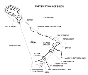
Fort St. Angelo is a bastioned fort in Birgu, Malta, located at the centre of the Grand Harbour. It was originally built in the medieval period as a castle called the Castrum Maris. It was rebuilt by the Order of Saint John as a bastioned fort called Fort Saint Angelo between the 1530s and the 1560s, and it is best known for its role as the Order's headquarters during the Great Siege of Malta of 1565. A major reconstruction to designs of Carlos de Grunenbergh took place in the 1690s, giving the fort its current appearance.

<span class="mw-page-title-main">Cottonera Lines</span>

The Cottonera Lines, also known as the Valperga Lines, are a line of fortifications in Bormla and Birgu, Malta. They were built in the 17th and 18th centuries on higher ground and further outwards than the earlier line of fortifications, known as the Santa Margherita or Firenzuola lines, which also surround Bormla.

<span class="mw-page-title-main">Floriana Lines</span> Line of fortifications in Floriana, Malta

The Floriana Lines are a line of fortifications in Floriana, Malta, which surround the fortifications of Valletta and form the capital city's outer defences. Construction of the lines began in 1636 and they were named after the military engineer who designed them, Pietro Paolo Floriani. The Floriana Lines were modified throughout the course of the 17th and 18th centuries, and they saw use during the French blockade of 1798–1800. Today, the fortifications are still largely intact but rather dilapidated and in need of restoration.

<span class="mw-page-title-main">Cittadella (Gozo)</span> Citadel in Victoria, Gozo, Malta

The Cittadella, also known as the Castello, is the citadel of Victoria on the island of Gozo, Malta. The area has been inhabited since the Bronze Age, and the site now occupied by the Cittadella is believed to have been the acropolis of the Punic-Roman city of Gaulos or Glauconis Civitas.

<span class="mw-page-title-main">Fort Chambray</span> Fortress in Malta

Fort Chambray or Fort Chambrai is a bastioned fort located in the precincts of Għajnsielem, on the island of Gozo, Malta. It was built in the mid-18th century by the Order of Saint John, in an area known as Ras it-Tafal, between the port of Mġarr and Xatt l-Aħmar. The fort was meant to be the citadel of a new city which was to replace the Cittadella as the island's capital, but this plan never materialized.

<span class="mw-page-title-main">Saint John's Cavalier</span>

Saint John's Cavalier is a 16th-century cavalier in Valletta, Malta, which was built by the Order of St. John. It overlooks St. John's Bastion, a large obtuse-angled bastion forming part of the Valletta Land Front. St. John was one of nine planned cavaliers in the city, although eventually only two were built, the other one being the identical Saint James Cavalier. It was designed by the Italian military engineer Francesco Laparelli, while its construction was overseen by his Maltese assistant Girolamo Cassar.

<span class="mw-page-title-main">Fortifications of Malta</span> Defensive military constructions of the Maltese archipelago

The fortifications of Malta consist of a number of walled cities, citadels, forts, towers, batteries, redoubts, entrenchments and pillboxes. The fortifications were built over thousands of years, from around 1450 BC to the mid-20th century, and they are a result of the Maltese islands' strategic position and natural harbours, which have made them very desirable for various powers.

<span class="mw-page-title-main">Santa Margherita Lines</span> Line of fortifications in Cospicua, Malta

The Santa Margherita Lines, also known as the Firenzuola Lines, are a line of fortifications in Cospicua, Malta. They were built in the 17th and 18th centuries to protect the land front defences of the cities of Birgu and Senglea. A second line of fortifications, known as the Cottonera Lines, was later built around the Santa Margherita Lines, while the city of Cospicua was founded in the 18th century within the Santa Margherita and Cottonera Lines.

<span class="mw-page-title-main">Fortifications of Valletta</span> Defensive walls in Valletta, Malta

The fortifications of Valletta are a series of defensive walls and other fortifications which surround Valletta, the capital city of Malta. The first fortification to be built was Fort Saint Elmo in 1552, but the fortifications of the city proper began to be built in 1566 when it was founded by Grand Master Jean de Valette. Modifications were made throughout the following centuries, with the last major addition being Fort Lascaris which was completed in 1856. Most of the fortifications remain largely intact today.

<span class="mw-page-title-main">Fortifications of Mdina</span> Defensive walls in Mdina, Malta

The fortifications of Mdina are a series of defensive walls which surround the former capital city of Mdina, Malta. The city was founded as Maleth by the Phoenicians in around the 8th century BC, and it later became part of the Roman Empire under the name Melite. The ancient city was surrounded by walls, but very few remains of these have survived.

<span class="mw-page-title-main">Fortifications of Senglea</span>

The fortifications of Senglea are a series of defensive walls and other fortifications which surround the city of Senglea, Malta. The first fortification to be built was Fort Saint Michael in 1552, and the majority of the fortifications were built over the next decade when it was founded by Grand Master Claude de la Sengle. Modifications continued until the 18th century, but large parts of the fortifications were demolished between the 19th and 20th centuries. Today, all that remain of Senglea's fortifications are the seaward bastions and part of the land front.

<span class="mw-page-title-main">Antonio Ferramolino</span>

Antonio Ferramolino was a 16th-century Italian architect and military engineer. He is also known as Sferrandino da Bergamo, and is called Hernan Molin in Spanish sources. He is mostly known for his work in Sicily, but he also designed fortifications in Ragusa and Malta.

<span class="mw-page-title-main">Malta at War Museum</span> War museum in Birgu, Malta

The Malta at War Museum is a museum in Birgu, Malta, which is dedicated to Malta's role in World War II. The museum is housed within a barrack block and a rock-hewn air-raid shelter within Couvre Porte Counterguard.

<span class="mw-page-title-main">Greeks Gate</span> City gate in Mdina, Malta

The Greeks Gate is a gate into the fortified city of Mdina, Malta. The gate was originally built in the medieval period, and its outer portal was built in the Baroque style in 1724 by Charles François de Mondion. Despite this, the rear part of its gate retains its original form, making it one of the few visible remains of Mdina's medieval walls.

<span class="mw-page-title-main">Maltese Baroque architecture</span> A form of Baroque architecture

Maltese Baroque architecture is the form of Baroque architecture that developed in Malta during the 17th and 18th centuries, when the islands were under the rule of the Order of St. John. The Baroque style was introduced in Malta in the early 17th century, possibly by the Bolognese engineer Bontadino de Bontadini during the construction of the Wignacourt Aqueduct. The style became popular in the mid to late 17th century, and it reached its peak during the 18th century, when monumental Baroque structures such as Auberge de Castille were constructed.
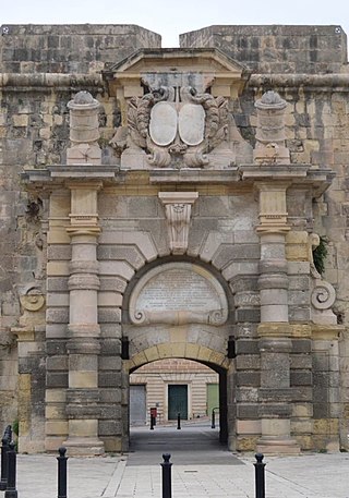
References

  1. "Knights' Fortifications around the Harbours of Malta". UNESCO Tentative List. Retrieved 12 June 2015.
  2. Spiteri, Stephen C. (26 July 2010). "Fort St Angelo during the Great Siege". MilitaryArchitecture.com. Archived from the original on 11 January 2017. Retrieved 12 June 2015.
  3. Zahra, Lorenzo A. (10 January 2007). "The Auberges of France in Birgu". The Malta Independent . Retrieved 10 June 2015.
  4. "Birgu's Fortifications". Birgu Local Council. Archived from the original on 20 October 2010. Retrieved 10 June 2015.
  5. "Explosion Polverista Vittoriosa". Medical Officers of the Malta Garrison. Archived from the original on 22 February 2017.
  6. "Protection of Antiquities Regulations 21st November, 1932 Government Notice 402 of 1932, as Amended by Government Notices 127 of 1935 and 338 of 1939". Malta Environment and Planning Authority . Archived from the original on 19 April 2016.
  7. Zammit, Ninu (12 December 2006). "Restoration of forts and fortifications". Times of Malta . Retrieved 10 June 2015.
  8. "A fortune on fortifications". Times of Malta . 20 June 2008. Retrieved 10 June 2015.
  9. "Restoration of the Birgu Fortifications - ERDF Project". Birgu Local Council. Archived from the original on 30 December 2014. Retrieved 10 June 2015.
  10. 1 2 "Pre-Great Siege bastion unearthed". Times of Malta . 5 October 2012. Retrieved 12 June 2015.
  11. "Bastions revealed as Vittoriosa's old oil depot is demolished". Times of Malta . 25 June 2010. Retrieved 12 June 2015.
  12. 1 2 "Arch bridges gap in bastions". Times of Malta . 13 April 2011. Retrieved 12 June 2015.
  13. "Il-foss tal-Birgu jingħata ħajja ġdida b'investiment ta' miljun ewro". TVM (in Maltese). 27 January 2016. Archived from the original on 27 January 2016.
  14. "Enceinte along Kalkara side - Birgu" (PDF). National Inventory of the Cultural Property of the Maltese Islands. 28 June 2013. Retrieved 13 July 2015.
  15. "Post of Castile - Birgu" (PDF). National Inventory of the Cultural Property of the Maltese Islands. 28 June 2013. Retrieved 13 July 2015.
  16. "St James Bastion - Birgu" (PDF). National Inventory of the Cultural Property of the Maltese Islands. 28 June 2013. Retrieved 13 July 2015.
  17. "St James Cavalier - Birgu" (PDF). National Inventory of the Cultural Property of the Maltese Islands. 28 June 2013. Retrieved 13 July 2015.
  18. "French Curtain - Birgu" (PDF). National Inventory of the Cultural Property of the Maltese Islands. 28 June 2013. Retrieved 13 July 2015.
  19. "St John Bastion - Birgu" (PDF). National Inventory of the Cultural Property of the Maltese Islands. 28 June 2013. Retrieved 13 July 2015.
  20. "St John Cavalier - Birgu" (PDF). National Inventory of the Cultural Property of the Maltese Islands. 28 June 2013. Retrieved 13 July 2015.
  21. "Couvre Porte Counterguard - Birgu" (PDF). National Inventory of the Cultural Property of the Maltese Islands. 28 June 2013. Retrieved 13 July 2015.
  22. "Visitor Information". Malta at War Museum. Retrieved 12 June 2015.
  23. "Short stretch of stepped curtain wall leading down to Birgu Creek - Birgu" (PDF). National Inventory of the Cultural Property of the Maltese Islands. 28 June 2013. Retrieved 13 July 2015.
  24. "Remains of Caponier - Birgu" (PDF). National Inventory of the Cultural Property of the Maltese Islands. 28 June 2013. Retrieved 13 July 2015.
  25. "Battery of Ditch - Birgu" (PDF). National Inventory of the Cultural Property of the Maltese Islands. 28 June 2013. Retrieved 13 July 2015.
  26. "Covertway - Birgu" (PDF). National Inventory of the Cultural Property of the Maltese Islands. 28 June 2013. Retrieved 13 July 2015.
  27. "The Couvre Porte". malta.com. Retrieved 12 June 2015.
  28. "Couvre Porte Gate - Birgu" (PDF). National Inventory of the Cultural Property of the Maltese Islands. 28 June 2013. Retrieved 13 July 2015.
  29. "Advanced Gate - Birgu" (PDF). National Inventory of the Cultural Property of the Maltese Islands. 28 June 2013. Retrieved 13 July 2015.
  30. "Main Gate - Birgu" (PDF). National Inventory of the Cultural Property of the Maltese Islands. 28 June 2013. Retrieved 13 July 2015.