Mohave County is a county in the northwestern corner of the U.S. state of Arizona. As of the 2020 census, its population was 213,267. The county seat is Kingman, and the largest city is Lake Havasu City. It is the fifth largest county in the United States.

Yavapai County is a county near the center of the U.S. state of Arizona. As of the 2020 census, its population was 236,209, making it the fourth-most populous county in Arizona. The county seat is Prescott.

The Apache–Sitgreaves National Forests is a 2.76-million-acre (11,169 km2) United States National Forest which runs along the Mogollon Rim and the White Mountains in east-central Arizona and into the U.S. state of New Mexico. Formerly two forests, it is currently managed as one unit by USDA Forest Service from the Forest Supervisors Office in Springerville, Arizona. Apache–Sitgreaves has over 400 species of wildlife. With its high elevation and cool summer breezes it is a popular weekend destination from the hot desert for Phoenix, Arizona, residents. The forest is divided into 5 Ranger Districts that span almost 300 miles (480 km) from Clifton, Arizona in the east-central portion of Arizona to the eastern boundary of the Coconino National Forest in north-central Arizona. The Apache–Sitgreaves National Forest borders the western and northern borders of the Fort Apache Indian Reservation. It is located in parts of Greenlee, Apache, Navajo, and Coconino counties in eastern and east-central Arizona, and Catron County in western New Mexico. The more northwesterly Sitgreaves National Forest portion lies adjacent to the north side of the Fort Apache Indian Reservation and is located entirely in Arizona, within Navajo, Apache, and Coconino counties. It has a total area of 818,651 acres (3,313 km2). The more southeasterly and much larger Apache National Forest portion lies adjacent to the east side of the Fort Apache and the San Carlos Indian Reservations. It lies on both sides of the border with New Mexico, in Greenlee, Catron, and Apache counties. It has a total area of 1,813,601 acres (7,339 km2).
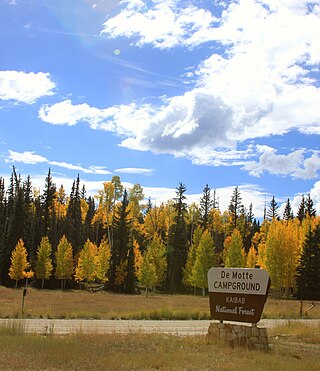
Kaibab National Forest borders both the north and south rims of the Grand Canyon, in north-central Arizona. Its 1.6 million acres is divided into three sections: the North Kaibab Ranger District, the Tusayan Ranger District, and the Williams Ranger District. It is managed by the United States Forest Service. Grand Canyon National Park separates the North Kaibab and the South Kaibab. The South Kaibab covers 1,422 square miles (3,680 km2) and the North Kaibab stretches over 1,010 square miles (2,600 km2). Elevations vary on the forest from 5,500 feet in the southwest corner to 10,418 feet at the summit of Kendrick Peak on the Williams Ranger District. The forest as a whole is headquartered in Williams.

The Tonto National Forest, encompassing 2,873,200 acres, is the largest of the six national forests in Arizona and is the ninth largest national forest in the United States. The forest has diverse scenery, with elevations ranging from 1,400 feet in the Sonoran Desert to 7,400 feet in the ponderosa pine forests of the Mogollon Rim. The Tonto National Forest is also one of the most visited "urban" forests in the United States.

Humphreys Peak is the highest natural point and the second most prominent peak after Mount Graham in the U.S. state of Arizona, with an elevation of 12,633 feet (3,851 m) and is located within the Kachina Peaks Wilderness in the Coconino National Forest, about 11 miles (17.7 km) north of Flagstaff, Arizona. Humphreys Peak is the highest of a group of dormant volcanic peaks known as the San Francisco Peaks.

The San Francisco Peaks are a volcanic mountain range in the San Francisco volcanic field in north central Arizona, just north of Flagstaff and a remnant of the former San Francisco Mountain. The highest summit in the range, Humphreys Peak, is the highest point in the state of Arizona at 12,633 feet (3,851 m) in elevation. The San Francisco Peaks are the remains of an eroded stratovolcano. An aquifer within the caldera supplies much of Flagstaff's water while the mountain itself is in the Coconino National Forest, a popular recreation site. The Arizona Snowbowl ski area is on the western slopes of Humphreys Peak, and has been the subject of major controversy involving several tribes and environmental groups.
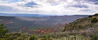
The Coconino National Forest is a 1.856-million acre United States National Forest located in northern Arizona in the vicinity of Flagstaff, with elevations ranging from 2,600 feet to the highest point in Arizona at 12,633 feet. Originally established in 1898 as the "San Francisco Mountains National Forest Reserve", the area was designated a U.S. National Forest by Pres. Theodore Roosevelt on July 2, 1908, when the San Francisco Mountains National Forest Reserve was merged with lands from other surrounding forest reserves to create the Coconino National Forest. Today, the Coconino National Forest contains diverse landscapes, including deserts, ponderosa pine forests, flatlands, mesas, alpine tundra, and ancient volcanic peaks. The forest surrounds the towns of Sedona and Flagstaff and borders four other national forests; the Kaibab National Forest to the west and northwest, the Prescott National Forest to the southwest, the Tonto National Forest to the south, and the Apache-Sitgreaves National Forest to the southeast. The forest contains all or parts of nine designated wilderness areas, including the Kachina Peaks Wilderness, which includes the summit of the San Francisco Peaks. The headquarters are in Flagstaff. The Coconino National Forest consists of three districts: Flagstaff Ranger District, Mogollon Rim Ranger District, and Red Rock Ranger District, which have local ranger district offices in Flagstaff, Happy Jack, and Sedona.

The Prescott National Forest is a 1.25 million-acre United States National Forest located in north central Arizona in the vicinity of Prescott. The forest is located in the mountains southwest of Flagstaff and north of Phoenix in Yavapai County, with a small portion extending into southwestern Coconino County.

The Arizona Strip is the part of Arizona lying north of the Colorado River. Despite being larger in area than several U.S. states, the entire region has a population of fewer than 10,000 people. Consisting of northeastern Mohave County and northwestern Coconino County, the largest settlements in the Strip are Colorado City, Fredonia, and Beaver Dam, with smaller communities of Scenic, Littlefield and Desert Springs. The Kaibab Indian Reservation lies within the region. Lying along the North Rim of the Grand Canyon creates physical barriers to the rest of Arizona. Only three major roads traverse the region: I-15 crosses the northwestern corner, while Arizona State Route 389 and U.S. Route 89A cross the northeastern part of the strip, and US 89A crosses the Colorado River via the Navajo Bridge, providing the only direct road connection between the strip and the rest of the state. The nearest metropolitan area is the St. George, Utah metro area, to which the region is more connected than to the rest of Arizona.

Mormon Lake is a shallow, intermittent lake located in northern Arizona in Pleasant Valley. With an average depth of only 10 ft (3.0 m), the surface area of the lake is extremely volatile and fluctuates seasonally. When full, the lake has a surface area of about 12 square miles (31 km2), making it the largest natural lake in Arizona. In particularly dry times, the lake has been known to dry up, leaving behind a remnant marsh.

Kendrick Peak or Kendrick Mountain is one of the highest peaks in the San Francisco volcanic field north of the city of Flagstaff in the U.S. state of Arizona and is located on the Coconino Plateau in Coconino County.

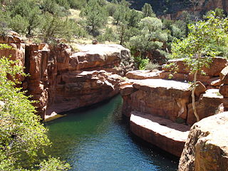
Oak Creek Canyon is a river gorge located in northern Arizona between the cities of Flagstaff and Sedona. The canyon is often described as a smaller cousin of the Grand Canyon because of its scenic beauty. State Route 89A enters the canyon on its north end via a series of hairpin turns before traversing the bottom of the canyon for about 13 miles (21 km) until the highway enters the town of Sedona.
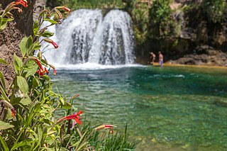
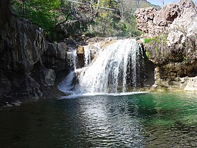
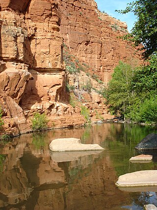
Fossil Creek is a perennial stream accessed by forest roads near the community of Camp Verde in the U.S. state of Arizona. Primary access is from Forest Road 708 off Arizona State Route 260 east of Camp Verde. A tributary of the Verde River, Fossil Creek flows from its headwaters on the Mogollon Rim to meet the larger stream near the former Childs Power Plant.
The West Clear Creek Wilderness is a 15,238-acre wilderness area in the U.S. state of Arizona. West Clear Creek is formed by the junction of Willow Creek and Clover Creek in the Mogollon Rim, which is part of the Colorado Plateau; the Mogollon Rim is the major part of the Arizona transition zone at the southwest of the Colorado Plateau of Utah-Colorado, Arizona-New Mexico. Located east of Camp Verde, the area is part of Coconino National Forest. Common activities in West Clear Creek are swimming, camping, backpacking, hunting, fishing, and hiking. A variety of plants and animals can be found year-round, along with extremely cold water.

Sycamore Canyon is the second largest canyon in the Arizona redrock country, after Oak Creek Canyon. The 21-mile (34 km) long scenic canyon reaches a maximum width of about 7 miles (11 km). It is in North Central Arizona bordering and below the Mogollon Rim, and is located west and northwest of Sedona in Yavapai and Coconino counties.
Sycamore Canyon Wilderness is a 56,000-acre wilderness area in the Coconino, Kaibab and Prescott national forests in the U.S. state of Arizona. Encompassing Sycamore Canyon and its surrounds from south of Williams to the confluence of Sycamore Creek with the Verde River, the wilderness is about 40 miles (64 km) southwest of Flagstaff. The canyon is one of several in Arizona that cut through the Mogollon Rim. Relevant United States Geological Survey (USGS) map quadrangles are Davenport Hill, White Horse Lake, May Tank Pocket, Perkinsville, Sycamore Basin, and Clarkdale. Red Rock-Secret Mountain Wilderness borders Sycamore Canyon Wilderness on the east.
Wet Beaver Wilderness is a 6,155-acre wilderness area located in the Coconino National Forest in the U.S. state of Arizona.

The Red Rock-Secret Mountain Wilderness is a 47,195-acre wilderness area located within the Coconino National Forest in the U.S. state of Arizona.

Strawberry Crater is a cinder cone volcano, more than 1,000 feet (300 m) high, in the San Francisco volcanic field, 20 miles (32 km) north of Flagstaff, Arizona. It is along Forest Road 545 between the Wupatki National Monument and Sunset Crater National Monument in the Strawberry Crater Wilderness. The crater lies in a volcanic field at a base elevation of about 5,500 feet (1,700 m), and prominence heights of about 6,526 feet (1,989 m). The northwestern end of the crater is covered with lava flows, while the southern end is filled with low cinder cones. Several of the surrounding cones include the better known, taller and younger Sunset Crater in the adjacent Sunset Crater National Monument.