Foster Bay

Last updated
Foster Bay
Greenland edcp relief location map.jpg
Red pog.svg
Foster Bay
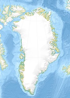
Location in Greenland
Location Arctic
Coordinates 73°15′N21°30′W / 73.250°N 21.500°W / 73.250; -21.500 Coordinates: 73°15′N21°30′W / 73.250°N 21.500°W / 73.250; -21.500
Ocean/sea sources Greenland Sea
Basin  countries Greenland

Foster Bay is a large bay of the Greenland Sea in King Christian X Land, Eastern Greenland.

Greenland Sea A body of water that borders Greenland to the west, the Svalbard archipelago to the east, south of the Fram Strait

The Greenland Sea is a body of water that borders Greenland to the west, the Svalbard archipelago to the east, Fram Strait and the Arctic Ocean to the north, and the Norwegian Sea and Iceland to the south. The Greenland Sea is often defined as part of the Arctic Ocean, sometimes as part of the Atlantic Ocean. However, definitions of the Arctic Ocean and its seas tend to be imprecise or arbitrary. In general usage the term "Arctic Ocean" would exclude the Greenland Sea. In oceanographic studies the Greenland Sea is considered part of the Nordic Seas, along with the Norwegian Sea. The Nordic Seas are the main connection between the Arctic and Atlantic oceans and, as such, could be of great significance in a possible shutdown of thermohaline circulation. In oceanography the Arctic Ocean and Nordic Seas are often referred to collectively as the "Arctic Mediterranean Sea", a marginal sea of the Atlantic.

King Christian X Land Region in Greenland

King Christian X Land is an area of northeastern Greenland.

Geography

The bay lies north-east of Geographical Society Island. The Kaiser Franz Joseph Fjord has its mouth in the bay, between Cape Mackenzie at the eastern end of Geographical Society Island and Cape Franklin, the southern end of the mainland's Gauss Peninsula; Bantekoe Island lies in the bay off the mouth of the fjord. [1]

Geographical Society Island island

Geographical Society Island is an island off Foster Bay in northeastern Greenland.

Gauss Peninsula

Gauss Peninsula is a peninsula in eastern Greenland. Administratively this peninsula is part of the Northeast Greenland National Park zone.

The eastern end of the Gauss Peninsula and the southern shore of Hold with Hope form the northern limit of the bay. [2]

Hold with Hope peninsula in Greenland

Hold with Hope is a peninsula in eastern Greenland. Administratively it is part of the Northeast Greenland National Park zone.

Related Research Articles

Uummannaq Fjord

Uummannaq Fjord is a large fjord system in the northern part of western Greenland, the largest after Kangertittivaq fjord in eastern Greenland. It has a roughly south-east to west-north-west orientation, emptying into the Baffin Bay in the northwest.

Peary Land peninsula

Peary Land is a peninsula in northern Greenland, extending into the Arctic Ocean. It reaches from Victoria Fjord in the west to Independence Fjord in the south and southeast, and to the Arctic Ocean in the north, with Cape Morris Jesup, the northernmost point of Greenland's mainland, and Cape Bridgman in the northeast.

Hendrik Island island in Greenland

Hendrik Island is an island in far northern Greenland. Its area is 583 km². It is part of the Northeast Greenland National Park.

Kaiser Franz Joseph Fjord fjord in Greenland

Kaiser Franz Joseph Fjord is a major fjord system in the NE Greenland National Park area, East Greenland.
Alanngorsuaq Fjord

Alanngorsuaq Fjord, also known as Coppermine Bay, is a fjord in the Kujalleq municipality in southern Greenland. At the mouth of the fjord the coastline of southwestern Greenland turns to the east towards Qaqortoq.

Sugar Loaf Bay is a bay in the Upernavik Archipelago in the Qaasuitsup municipality in northwestern Greenland. It is an indentation of northeastern Baffin Bay. The name of the bay derives from the name of an island of the same name in the bay, Sugar Loaf Island.

Bernstorff Fjord

Bernstorff Fjord is a fjord in King Frederick VI Coast, eastern Greenland.

Kangerlussuaq Fjord, East Greenland Fjord Greenland, Sermersooq

Kangerlussuaq Fjord is a fjord in eastern Greenland. It is part of the Sermersooq municipality.

Umivik Bay bay in Greenland

Umivik Bay, also known as Umiivik and Umerik, is a bay in King Frederick VI Coast, southeastern Greenland. It is part of the Sermersooq municipality.

Anorituup Kangerlua

Anorituup Kangerlua, also known as Anoritoq or Anortek Fjord, is a fjord in King Frederick VI Coast, southern Greenland.

Pikiulleq

Pikiulleq is a bay in eastern Greenland. It is part of the Sermersooq municipality.

Ingolf Fjord fjord in Greenland

Ingolf Fjord, also known as Ingolf Sound, is a fjord of Greenland's northeastern coast in northern King Frederick VIII Land.

Adolf S. Jensen Land peninsula in Greenland

Adolf S. Jensen Land is a peninsula in the southern limit of King Frederick VIII Land, northeastern Greenland. Administratively it belongs to the NE Greenland National Park area.

Denmark expedition 1906–1908 expedition to Greenland

The Denmark expedition, also known as Denmark Expedition to Greenland's Northeast Coast, and as the Danmark Expedition after the ship, was an expedition to the northeast of Greenland in 1906–1908.

Wulff Land

Wulff Land is a peninsula in far northwestern Greenland. Administratively it is a part of the Northeast Greenland National Park.

Bessel Fjord, NW Greenland fjord in Greenland

Bessel Fjord, also known as Bessels Bay, is a fjord in northwestern Greenland. Administratively it belongs to the Avannaata municipality.

Inglefield Gulf

Inglefield Gulf or Inglefield Fjord is a fjord in northwestern Greenland. To the west, the fjord opens into the Baffin Bay. Administratively it belongs to the Avannaata municipality.
References

  1. Prostar Sailing Directions 2005 Greenland and Iceland Enroute, p. 120
  2. "Catalogue of place names in northern East Greenland". Geological Survey of Denmark. Retrieved 18 June 2016.[ permanent dead link ]