Related Research Articles

Signy Island is a small subantarctic island in the South Orkney Islands of Antarctica. It was named by the Norwegian whaler Petter Sørlle (1884–1933) after his wife, Signy Therese.

Coronation Island is the largest of the South Orkney Islands, 25 nautical miles (46 km) long and from 3 to 8 nautical miles wide. The island extends in a general east–west direction, is mainly ice-covered and comprises numerous bays, glaciers and peaks, the highest rising to 1,265 metres (4,150 ft).

The Larsen Islands are a small group of islands north-west of Moreton Point, the western extremity of Coronation Island, in the South Orkney Islands of Antarctica. They were discovered by Captains George Powell and Nathaniel Palmer on the occasion of their joint cruise in December 1821. The islands were named on Petter Sørlle's chart, based upon his survey of the South Orkney Islands in 1912–1913, in honour of Carl Anton Larsen.

False Bay is a bay 4 miles (6.4 km) long, which lies between Barnard Point and Miers Bluff on the south side of Livingston Island, in the South Shetland Islands, Antarctica. The glaciers Hurd Ice Cap, Huntress, Ruen Icefall, Peshtera and Charity feed the bay.

McFarlane Strait is a strait lying between Greenwich Island and Livingston Island, in the South Shetland Islands off Antarctica. It is 24 kilometres (13 nmi) long and 3 kilometres (1.6 nmi) wide. The name appears on an 1822 chart by Captain George Powell, a British sealer, and is now well established in international usage.

Barnard Point is a headland which marks the south-east side of the entrance to False Bay on the south side of Livingston Island in the South Shetland Islands, Antarctica. It is situated on Rozhen Peninsula, 1.5 km (1 mi) north-north-west of Botev Point and 6.6 km (4 mi) south-east of Miers Bluff.
Cape Bennett is a bold promontory at the northeast extremity of Coronation Island, in the South Orkney Islands.
Bridger Bay is a semi-circular bay 2.5 nautical miles (5 km) wide, lying west of Tickell Head along the north coast of Coronation Island, in the South Orkney Islands. It was discovered in 1821 in the course of the joint cruise by Captain Nathaniel Palmer, an American sealer, and Captain George Powell, a British sealer. It was surveyed by the Falkland Islands Dependencies Survey in 1956–58 and named by the UK Antarctic Place-Names Committee for John F.D. Bridger, who participated in the survey of Coronation Island and Signy Island.
Conception Point is the northernmost point on Coronation Island in the South Orkney Islands. It was discovered on 8 December 1821, in the course of the joint cruise by Captain George Powell, British sealer, and Captain Nathaniel Palmer, American sealer. It was named by Captain Powell.
Crown Head is a headland forming the east side of Palmer Bay on the north coast of Coronation Island, in the South Orkney Islands. It was first seen in the course of the joint cruise by Captain George Powell, a British sealer, and Captain Nathaniel Palmer, an American sealer, in December 1821. It was surveyed by the Falkland Islands Dependencies Survey in 1956–58. The name derives from an association with Coronation Island and was given by the UK Antarctic Place-Names Committee in 1959.
Jessie Bay is a bay 4 nautical miles (7 km) wide, lying between Mackenzie Peninsula and Pirie Peninsula, on the north side of Laurie Island in the South Orkney Islands. Apparently seen in the course of the joint cruise by Captain George Powell, a British sealer, and Captain Nathaniel Palmer, an American one. In 1821, it was roughly charted by Captain James Weddell, a British sealer. It was surveyed in 1903 by the Scottish National Antarctic Expedition of William S. Bruce, who named this bay for his wife, Jessie Mackenzie Bruce. He also named a cove in the bay, Sheila Cove, for his daughter.
Purdy Point is a point 1.5 nautical miles (2.8 km) east-southeast of Foul Point on the north coast of Coronation Island, in the South Orkney Islands. First seen in December 1821 in the course of a joint cruise by Captain George Powell, British sealer, and Captain Nathaniel Palmer, American sealer, and roughly shown on Powell's chart. Surveyed by the Falkland Islands Dependencies Survey (FIDS) in 1956-58 and named by the United Kingdom Antarctic Place-Names Committee (UK-APC) in 1959 for John Purdy (1773–1843), a leading English hydrographer of his day, who compiled numerous nautical directories and charts, including the South Orkney Islands, the forerunners of Admiralty sailing directions.
Ellefsen Harbour is a harbour lying at the south end of Powell Island between Christoffersen Island and Michelsen Island, in the South Orkney Islands. It was discovered in the course of a joint cruise by Captain George Powell, a British sealer, and Captain Nathaniel Palmer, an American sealer, in December 1821. Shortly afterward, it was briefly occupied by Sam Pointer. The name first appeared on Powell's chart published in 1822.
Findlay Point is a point 2 nautical miles (4 km) northwest of Palmer Bay on the north coast of Coronation Island, in the South Orkney Islands. It was first seen in December 1821 in the course of the joint cruise by Captain George Powell, British sealer, and Captain Nathaniel Palmer, American sealer, and roughly charted by Powell. It was surveyed by the Falkland Islands Dependencies Survey in 1956–58 and named by the UK Antarctic Place-Names Committee for Alexander George Findlay, an English geographer and hydrographer who compiled a long series of nautical directories and charts, including the South Orkney Islands.
Spence Harbor is a small bay 1 nautical mile (1.9 km) south of The Turret, along the east coast of Coronation Island, in the South Orkney Islands. Discovered in December 1821 by Captain George Powell, a British sealer in the sloop Dove, who named the bay, and Captain Nathaniel Palmer, an American sealer in the sloop James Monroe.
Tickell Head is a headland forming the east side of Bridger Bay on the north coast of Coronation Island, in the South Orkney Islands. First seen in December 1821 in the course of the joint cruise by Captain Nathaniel Palmer, American sealer, and Captain George Powell, British sealer. Surveyed by the Falkland Islands Dependencies Survey (FIDS) in 1956-58 and named by the United Kingdom Antarctic Place-Names Committee (UK-APC) in 1959 for William L.N. Tickell, FIDS meteorologist at Signy Island in 1955 and leader at that station in 1956.

Return Point is a rocky slope forming the south-west extremity of Coronation Island, in the South Orkney Islands of Antarctica. It lies 2 km west-north-west of Cheal Point.

Lewthwaite Strait is a passage 2.5 nautical miles (5 km) wide, lying between Coronation Island and Powell Island in the South Orkney Islands, Antarctica. It was discovered in December 1821, on the occasion of the joint cruise of Captain George Powell, a British sealer in the sloop Dove, and Captain Nathaniel Palmer, an American sealer in the sloop James Monroe. Mr. Lewthwaite was a teacher of navigation in Prince's Street, Rotherhithe, London; Captain Powell left the chart and journal of his Antarctic exploration with Lewthwaite before sailing on his last expedition, on which he met his death.
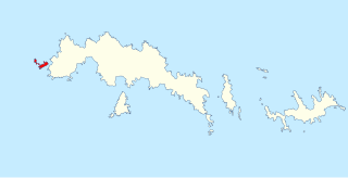
Penguin Point is a point which forms the northwestern extremity of Coronation Island in the South Orkney Islands of Antarctica.
Ommanney Bay is a bay 2 mi (3.2 km) wide between Prong Point and Foul Point on the north coast of Coronation Island, in the South Orkney Islands of Antarctica. Like much of Coronation Island and its surrounding features, it was first seen and roughly charted by Captain George Powell and Captain Nathaniel Palmer in 1821. It was recharted in 1933 by Discovery Investigations personnel on the Discovery II and named for Francis D. Ommanney, zoologist on the staff of the Discovery Committee.
References
- ↑ "Foul Point". Geographic Names Information System . United States Geological Survey, United States Department of the Interior . Retrieved 3 April 2012.
![]() This article incorporates public domain material from "Foul Point". Geographic Names Information System . United States Geological Survey.
This article incorporates public domain material from "Foul Point". Geographic Names Information System . United States Geological Survey.
60°32′S45°29′W / 60.533°S 45.483°W